Forecast for the Moab Area Mountains

Dave Garcia
Issued by Dave Garcia for
Wednesday, November 30, 2022
A MODERATE avalanche danger exists on slopes that face W-N-SE near treeline and above treeline anywhere wind drifted snow has created a slab on top of our weak, fragile snowpack. Human triggered avalanches are possible on these slopes. Slopes that face SW-S and below treeline terrain offers a LOW danger.
It's still low tide out there and rocks, stumps, and deadfall are lurking just beneath the surface. A ride in even a small avalanche in these low snow conditions would be rugged.
Low
Moderate
Considerable
High
Extreme
Learn how to read the forecast here
Special Announcements
We will be giving a free Know Before You Go Avalanche Awareness talk on Tuesday, Dec 6 at 6:00 p.m. at the MARC (111 E 100 N).
Join us for the 1st Annual UAC Moab/LUNA Winter Kickoff Party on Saturday, Dec 10 at the MARC. The event will be from 7-9 PM. Get your tickets here.
Join the Utah Avalanche Center and the Division of Outdoor Recreation to celebrate the Fourth Annual Avalanche Awareness Week, from December 4 - December 11. Click HERE to view a full list of events throughout the state.
Road Conditions: Grand County has not yet begun plowing the road to Geyser Pass Trailhead. The road is hard-packed snow and slick in places. Good tires and all wheel drive are recommended.
Grooming: The Geyser Pass Road above the winter trailhead closes on Dec 15. Grooming will commence after that.
Weather and Snow
24 Hour Snow 0" 72 Hour Snow 7" Season Total Snow 41" Base Depth at Gold Basin 24" Wind W 7 G11 Temp 12 F
The winds have backed off a bit overnight and temperatures are on the rise this morning. Today should be another beautiful day in the mountains. The sun will be shining and there is a fresh coat of white. As the day goes on we will see the wind shift to the SW and increase, averaging 15-25 mph. Moderate to strong SW winds will remain in place ahead of the next storm system that will move in late Thursday night bringing snow showers on Friday. Accumulations will be small from the Friday storm, but the good news is another system is on tap for Sunday.
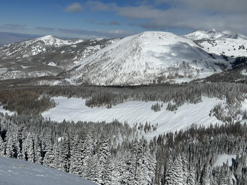
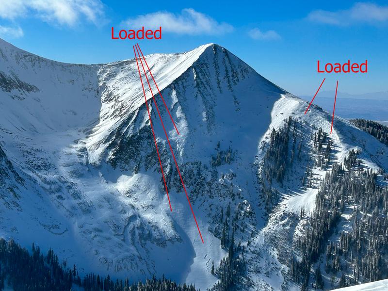
Seven inches of snow fell Monday night and greatly improved the skiing and riding. On slopes that are sheltered from the wind, you will find classic low density Utah fluff. The wind certainly had an easy time blowing and drifting all this light snow around and you will find plenty of fresh slabs of wind drifted snow on open slopes near treeline and above.
If you are getting up into the mountains please submit an observation and let us know what you are seeing!
Get the most recent observations here.
Get current and past 24-hour readings from these real-time weather links:
Snow and Snow Water Equivalent (SWE) at the Gold Basin SNOTEL site (10,000')
Snow and Snow Water Equivalent (SWE) near the Geyser Pass Winter Trailhead (9600')
Wind Speed and Direction on Pre-Laurel Peak (11,400')
NWS point forecast for the La Sal Mountains.
Recent Avalanches
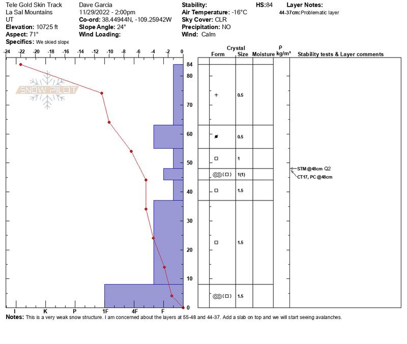
No recent avalanches have been reported from the backcountry.
Ad
Avalanche Problem #1
Wind Drifted Snow
Type
Location
Likelihood
Size
Description
Monday night’s storm buried some very weak layers under seven inches of low density snow. The weight of the new snow alone is not enough to overload our weak snow pack. You should be concerned about slopes where wind drifted snow has deposited a slab on top of the underlying weak snow. These slopes are stressed to just about their breaking point and the weight of a skier or rider may be all it takes to make them avalanche. In my travels yesterday I observed fresh drifts up to a foot deep on open slopes that have been cross loaded by up canyon winds, gullies that have been cross loaded, and just below ridge lines on leeward slopes. I also noticed fresh drifts mid slope on leeward terrain, maybe further down than you might expect. These slopes are especially worrisome because they can allow you to get further out on the slab before the weak layer fails. These are places where you might trigger an avalanche right now. SW winds will blow in the moderate range today and continue to deposit fresh drifts on leeward terrain.
The good news is wind drifted snow is easy to identify by its rounded, pillowy nature. Check out the photos below for some examples. There is also an obvious change in density when you step out onto a fresh drift. Cracks forming around your feet or shooting out in front of your skis are also signs that you have stepped onto a wind drift. Avoid fresh wind drifts today and you will avoid the avalanche problem.
The open slope in the photo below has been completely cross loaded by up canyon winds. Notice the pillowy nature of the snow across the entire slope.
The photo below shows another example of recent loading. Leeward slopes beneath ridge lines are loaded, but notice the slope down low that has also been freshly loaded
Additional Information
This snow profile shows our very weak snowpack that was just buried by seven inches of snow.
Even if you're not planning to get onto the snow, it's never too early to start thinking about avalanches. A few things to consider doing:
  • Sign up for an avalanche class.
  • Take the all-new online avalanche courses the UAC built for Know Before You Go or take other online courses listed on the KBYG website (Develop skills -> Online Learning).
  • Get your avalanche rescue gear ready for winter. Put fresh batteries in your transceiver and update the firmware. Inspect your shovel and probe. Get your airbag backpack ready by possibly doing a test deployment and update the firmware if it is an electric version.
This forecast is from the U.S.D.A. Forest Service, which is solely responsible for its content. This forecast describes general avalanche conditions and local variations always occur.
General Announcements
This forecast is from the U.S.D.A. Forest Service, which is solely responsible for its content. This forecast describes general avalanche conditions and local variations always occur.