Forecast for the Moab Area Mountains

Dave Garcia
Issued by Dave Garcia for
Tuesday, November 29, 2022
There is a MODERATE danger for triggering avalanches in wind drifted snow on slopes that face NW-SE near treeline and above treeline. Be suspicious of any area with more than six inches of wind drifted snow. West and South aspects have very little snow and offer LOW avalanche danger.
It's still low tide out there and rocks, stumps, and deadfall are lurking just beneath the surface. A ride in even a small avalanche in these low snow conditions would be rugged.
Low
Moderate
Considerable
High
Extreme
Learn how to read the forecast here
Special Announcements
We will be giving a free Know Before You Go Avalanche Awareness talk on Tuesday, Dec 6 at 6:00 p.m. at the MARC (111 E 100 N).
Join us for the 1st Annual UAC Moab/LUNA Winter Kickoff Party on Saturday, Dec 10 at the MARC. The event will be from 7-9 PM. Get your tickets here.
Join the Utah Avalanche Center and the Division of Outdoor Recreation to celebrate the Fourth Annual Avalanche Awareness Week, from December 4 - December 11. Click HERE to view a full list of events throughout the state.
Road Conditions: Grand County has not yet begun plowing the road to Geyser Pass Trailhead. The road is hard-packed snow and slick in places. Good tires and all wheel drive are recommended.
Grooming: The Geyser Pass Road above the winter trailhead closes on Dec 15. Grooming will commence after that.
Weather and Snow
24 Hour Snow 6" 72 Hour Snow 6" Season Total Snow 40" Base Depth at Gold Basin 23" Wind NW 15 G22 Temp 8 F
About six inches of snow has fallen overnight. SW winds cranked last night, averaging in the 20's with gusts in the 30's. The winds have shifted to the NW and will continue to blow in the 20-30 range. We could see gusts as high as 45 today. Temperatures have plummeted and it will remain cold today. High temps will be in the single digits. We will see light snow showers this morning and we may pick up another 1-2" before skies clear this afternoon and the winds decrease. Wednesday returns to a SW flow and a transitory ridge of high pressure will allow temperatures to bounce back. Temps will climb throughout the week ahead of the next system that is slated to impact us on Friday. The pattern looks active through the weekend.
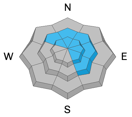
Six inches of snow will give the surface a much needed refresh. The snowpack on northerly-facing slopes is cold, weak, and shallow. On these aspects, weak, sugary facets have developed in every layer of the pack. Solar aspects have very little snow. It's still low tide out there and rocks, stumps, and other obstacles are barely covered up.
If you are getting up into the mountains please submit an observation and let us know what you are seeing!
Get the most recent observations here.
Get current and past 24-hour readings from these real-time weather links:
Snow and Snow Water Equivalent (SWE) at the Gold Basin SNOTEL site (10,000')
Snow and Snow Water Equivalent (SWE) near the Geyser Pass Winter Trailhead (9600')
Wind Speed and Direction on Pre-Laurel Peak (11,400')
NWS point forecast for the La Sal Mountains.
Ad
Avalanche Problem #1
Wind Drifted Snow
Type
Location
Likelihood
Size
Description
There is some uncertainty about snow totals, but it appears that last night's storm brought six inches of cold, low density snow. The new snow will be easily transported by moderate to strong NW winds throughout the day. We currently have a weak foundation of snow from prolonged cold clear weather. Today it will be possible to trigger avalanches in areas of wind drifted snow that have formed sensitive cohesive slabs on top of our weak faceted snow pack. Wind drifts will appear round and pillowy, and they will sound hollow and drum like. Shooting cracks are an obvious sign of instability. With some level of uncertainty about snow totals, you should be especially cautious if you are traveling in avalanche terrain today.
Additional Information
Even if you're not planning to get onto the snow, it's never too early to start thinking about avalanches. A few things to consider doing:
  • Sign up for an avalanche class.
  • Take the all-new online avalanche courses the UAC built for Know Before You Go or take other online courses listed on the KBYG website (Develop skills -> Online Learning).
  • Get your avalanche rescue gear ready for winter. Put fresh batteries in your transceiver and update the firmware. Inspect your shovel and probe. Get your airbag backpack ready by possibly doing a test deployment and update the firmware if it is an electric version.
This forecast is from the U.S.D.A. Forest Service, which is solely responsible for its content. This forecast describes general avalanche conditions and local variations always occur.
General Announcements
This forecast is from the U.S.D.A. Forest Service, which is solely responsible for its content. This forecast describes general avalanche conditions and local variations always occur.