Forecast for the Moab Area Mountains

Eric Trenbeath
Issued by Eric Trenbeath for
Thursday, December 1, 2022
A MODERATE avalanche danger exists on slopes that face W-N-SE near treeline and above where slabs of wind drifted snow exist on top of a weak, fragile snowpack. Human triggered avalanches are possible on these slopes. Slopes that face SW-S and below treeline terrain offers a LOW danger.
It's still low tide out there and rocks, stumps, and deadfall are lurking just beneath the surface. A ride in even a small avalanche in these low snow conditions would be rugged.
Low
Moderate
Considerable
High
Extreme
Learn how to read the forecast here
Special Announcements
We will be giving a free Know Before You Go Avalanche Awareness talk on Tuesday, Dec 6 at 6:00 p.m. at the MARC (111 E 100 N).
Join us for the 1st Annual UAC Moab/LUNA Winter Kickoff Party on Saturday, Dec 10 at the MARC. The event will be from 7-9 PM. Get your tickets here.
Join the Utah Avalanche Center and the Division of Outdoor Recreation to celebrate the Fourth Annual Avalanche Awareness Week, from December 4 - December 11. Click HERE to view a full list of events throughout the state.
Road Conditions: Grand County has not yet begun plowing the road to Geyser Pass Trailhead. The road is hard-packed snow and slick in places. Good tires and all wheel drive are recommended.
Grooming: The Geyser Pass Road above the winter trailhead closes on Dec 15. Grooming will commence after that.
Weather and Snow
24 Hour Snow 0" 72 Hour Snow 7" Season Total Snow 41" Base Depth at Gold Basin 21"
Winds on Pre Laurel Peak S 20-25 G35 Temp 26F
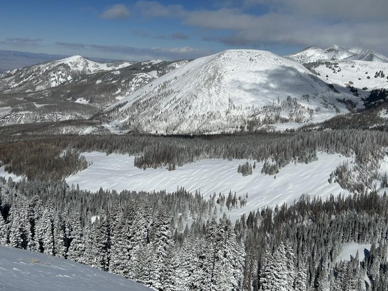
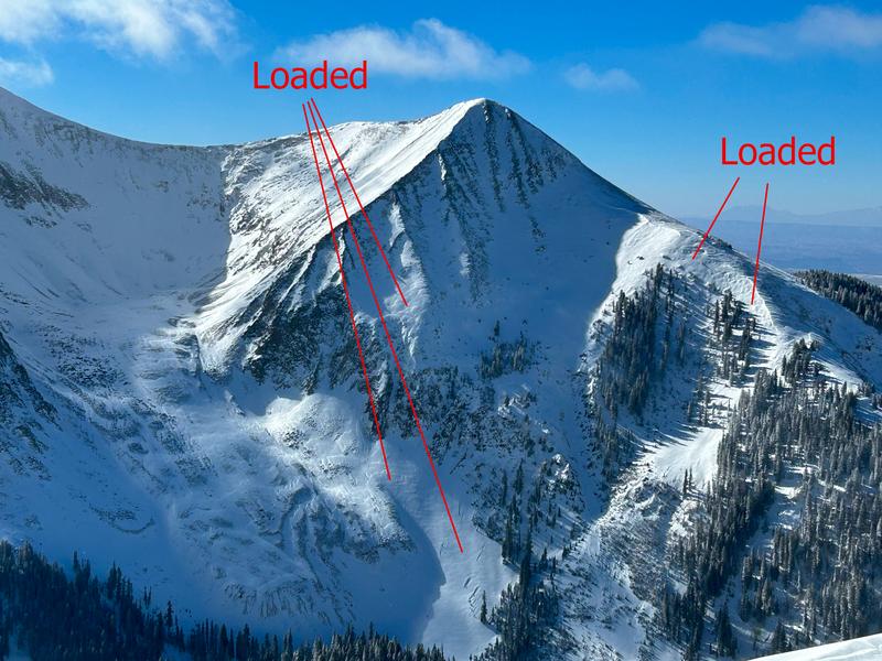
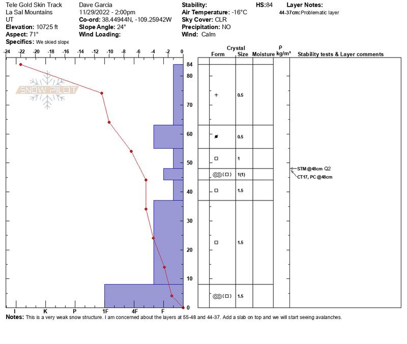
The story is the wind. Southerly winds have been on the increase since yesterday afternoon averaging close to 30 mph, with gusts as high as 40 mph on ridge tops. Today, look for increasing clouds and wind ahead of a low pressure system moving into the region. Unfortunately for us, we're going to see a lot of huff and puff and not much fluff as the storm track is to the north. We should see some snow flurries by early Friday morning with maybe an inch or two of accumulation. Cloudy and breezy conditions persist through Saturday with the next system moving in on Sun- Mon. This storm doesn't look to be much of a producer for us either. An unsettled pattern remains in place through next week, we'll see if anything shapes up.
Southerly winds are continuing to drift Monday's seven inches of low density snow, forming unstable slabs on leeward slopes near and above treeline. Alternately, windward surfaces are scoured, crusted, and sculpted. Complicating the picture are older wind slabs that formed earlier this week, all of which are sitting on top of a foundation of weak, sugary, faceted snow. The bottom line is that the snowpack isn't shaping up all that well and we will soon be facing a persistent weak layer problem. It's also still low tide out there with lots of rocks, stumps, and logs lurking about. It's just not quite game on yet, we need another foot or so of snow.
If you are getting up into the mountains please submit an observation and let us know what you are seeing!
Get the most recent observations here.
Get current and past 24-hour readings from these real-time weather links:
Snow and Snow Water Equivalent (SWE) at the Gold Basin SNOTEL site (10,000')
Snow and Snow Water Equivalent (SWE) near the Geyser Pass Winter Trailhead (9600')
Wind Speed and Direction on Pre-Laurel Peak (11,400')
NWS point forecast for the La Sal Mountains.
Recent Avalanches
No recent avalanches have been reported from the backcountry.
Ad
Avalanche Problem #1
Wind Drifted Snow
Type
Location
Likelihood
Size
Description
Southerly winds have created fresh slabs of wind drifted snow on slopes facing W through N through SE. Wind slabs are recognizable by their smooth, rounded, "pillowy" appearance and they may sound hollow underneath. Cracking is a sign of instability. Look for unstable areas of wind drifted snow on the the leeward sides of ridge crests and terrain features such as rock outcroppings, sub ridges, and gully walls. Due to higher wind speeds, they may also exist further down slope than you expect. Avoid steep slopes that have recent deposits of wind drifted snow.
The photos below were taken by Dave Garcia earlier this week. Note the pillowy nature of recent wind drifting as well as down slope loading.
Additional Information
This snow profile shows our very weak snowpack that was just buried by seven inches of snow.
Even if you're not planning to get onto the snow, it's never too early to start thinking about avalanches. A few things to consider doing:
  • Sign up for an avalanche class.
  • Take the all-new online avalanche courses the UAC built for Know Before You Go or take other online courses listed on the KBYG website (Develop skills -> Online Learning).
  • Get your avalanche rescue gear ready for winter. Put fresh batteries in your transceiver and update the firmware. Inspect your shovel and probe. Get your airbag backpack ready by possibly doing a test deployment and update the firmware if it is an electric version.
This forecast is from the U.S.D.A. Forest Service, which is solely responsible for its content. This forecast describes general avalanche conditions and local variations always occur.
General Announcements
This forecast is from the U.S.D.A. Forest Service, which is solely responsible for its content. This forecast describes general avalanche conditions and local variations always occur.