Join us at our 2nd Annual Blizzard Ball

Forecast for the Moab Area Mountains

Dave Garcia
Issued by Dave Garcia on
Friday morning, January 6, 2023
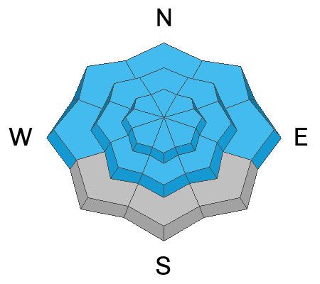
A CONSIDERABLE danger exists for triggering avalanches on a deeply buried persistent weak layer on slopes near treeline and above that face W-NW-N-E-SE. Human triggered avalanches remain likely on these slopes. This buried weak layer also exists on slopes that face SW-S, and most slopes below treeline. These slopes offer a MODERATE danger. Careful snowpack evaluation and cautious route-finding are essential for backcountry travel today.
Strong, continuous Southerly winds over the past 24 hours have created fresh slabs of wind drifted snow on all aspects above treeline and near treeline slopes that face NW-N-NE-E.
Low
Moderate
Considerable
High
Extreme
Learn how to read the forecast here
Special Announcements
Road Conditions: The road is plowed, but there are still some deep spots and ruts, especially near the top. 4x4 recommended.
Grooming: All trails have been groomed and are in excellent shape.
Improve your avalanche awareness and rescue skills and sign up for our Backcountry 101 Class on January 20, 21.
Weather and Snow
24 Hour Snow 0" 72 Hour Snow 0" Season Total Snow 130" Base Depth at Gold Basin 61"
Winds on Pre Laurel Peak SW 14 G24 Temp 19F
Weather
The small storm that was scheduled to hit us yesterday has stalled out a bit and there is no new snow in the La Sals. The trough of low pressure is currently centered over central Utah. SW flow will increase today giving us light snow showers throughout the day. We still have the potential to pick up 2-4" of snow by midnight. SW winds will blow 15 mph today. Skies will clear tonight and winds will shift to the NW on the backside of the low. Saturday will be sunny and cold with light to moderate NW winds. Sunday and Monday will be continued sunny and cold with the next chance for snow Monday night.

General Conditions
All of that great storm snow we have been skiing is starting to settle down. Winds were really cranking yesterday from the SSE. If you're skiing above treeline today you will find fresh slabs of wind drifted snow and alternately scoured slopes on the windward aspects. Soft, settled snow still exists in sheltered areas and should offer fun conditions today. While the buried persistent weak layer remains our number one avalanche problem, skiers and riders should be on the lookout for fat rounded pillows of freshly drifted snow near and above treeline today.
Lots of folks have been getting up and enjoying all the great snow, you can read all La Sal observations here.
Snowpack and Weather Data
Gold Basin Storm Stake (10,000')
Gold Basin SNOTEL site (10,000')
SNOTEL site near Geyser Pass Winter Trailhead (9600')
Wind Station on Pre-Laurel Peak (11,400')
NWS forecast for the La Sal Mountains.
Recent Avalanches
The last big loading event caused widespread natural activity. I have updated the avalanche database which can be viewed here.
Ad
Avalanche Problem #1
Persistent Weak Layer
Type
Location
Likelihood
Size
Description
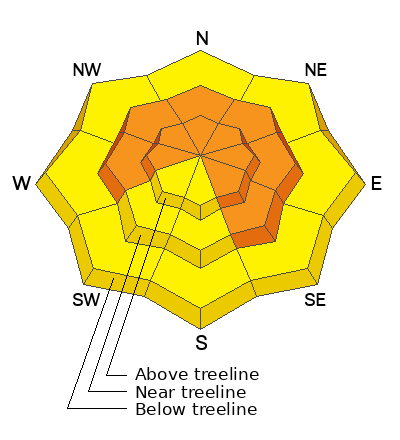
A buried persistent weak layer that formed in November is present on all aspects in the La Sal range. The big New Year's storm produced several large and destructive avalanches near treeline and above on slopes that face NW-N-NE. Blowing and drifting snow is continuing to add stress to these slopes and you will find the greatest danger on the North half of the compass. Recent stability tests have shown that the weak layer is gaining strength. Avalanches are becoming harder to trigger on this layer, but the consequences remain the same. Any avalanche triggered on the deeply buried PWL would be massive and devastating.
Signs of instability have become less obvious as we get further away from our last loading event. The very large crowns and debris piles around Gold Basin should be a good reminder of what is lurking under the snow. Most accidents occur when the danger is moving from Considerable to Moderate, keep this in mind today.
Avalanche Problem #2
Wind Drifted Snow
Type
Location
Likelihood
Size
Description
On Thursday winds out of the SSE were blowing in the 30's with gusts in the 40's. Plumes of snow could be seen shooting off the high peaks from down in town. Fresh soft slabs of wind drifted snow will be most pronounced on leeward slopes on the North half of the compass. These slopes will be loaded well below ridge lines today, further down than you might expect. Strong winds have the ability to load any aspect, because terrain features can cause winds to shift and change direction. Look for fresh drifts on all aspects above treeline.
Wind drifted snow is stiffer and more cohesive than non drifted snow. Hard drifts often sound hollow and drum like. Freshly formed wind drifts are quite sensitive and easily triggered. Old, hard wind slabs can be stubborn and allow you to get far out on to them before they fail. Shooting cracks in the snow are a good indicator that you have stepped onto a wind drift.
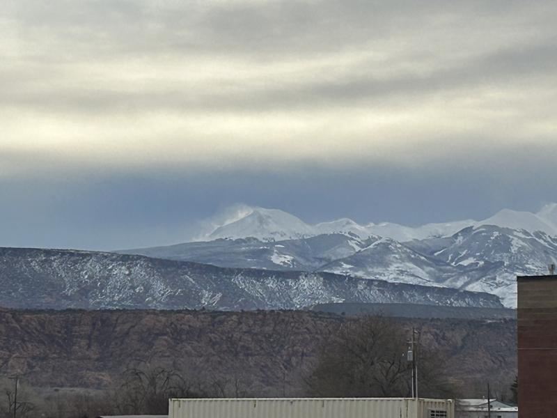
I took this photo on Thursday as I was gassing up to head to the Abajos. The peak in the center is Mt. Mellenthin. The plumes of snow shooting off the peak are obvious. Even from town we can tell that Northerly slopes were being loaded up yesterday.
Additional Information
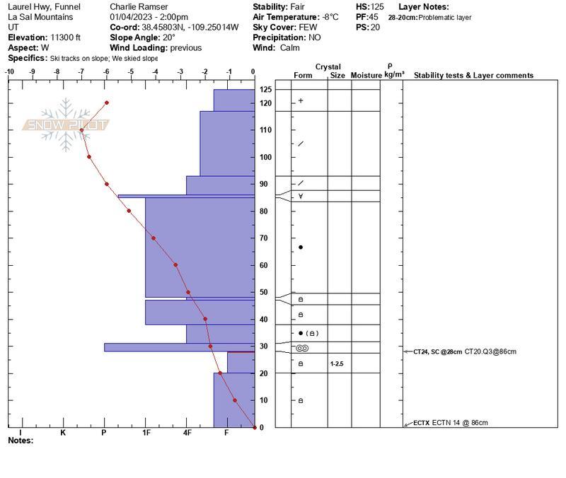
Check out this detailed snow profile from Charlie Ramser and Maggie Nielson from their travels Wednesday.
General Announcements
This forecast is from the U.S.D.A. Forest Service, which is solely responsible for its content. This forecast describes general avalanche conditions and local variations always occur. This forecast will be updated by 7:30 tomorrow morning.