Join us at our 2nd Annual Blizzard Ball

Forecast for the Moab Area Mountains

Dave Garcia
Issued by Dave Garcia on
Thursday morning, January 5, 2023
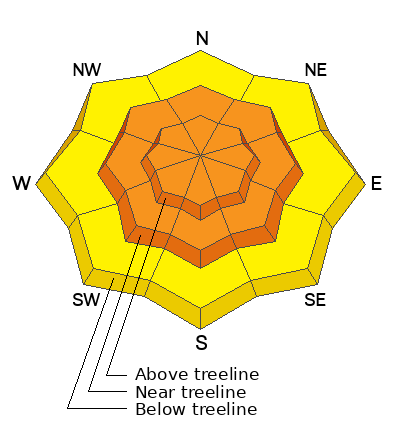
CONSIDERABLE avalanche danger exists on all slopes near treeline and above. Deep and dangerous human triggered avalanches failing on a buried persistent weak layer are LIKELY. These avalanches can be 4-6 feet deep and hundreds of feet wide. The danger is greatest on steep, wind drifted slopes that face NW-N-NE-E. Backcountry travelers should continue to avoid slopes steeper than 30 degrees.
Increasing SW winds will create fresh slabs of wind drifted snow on all aspects above treeline and near treeline on slopes that face NW-N-NE-E. It is LIKELY for skiers and riders to trigger an avalanche in a fresh sensitive drift today. It is POSSIBLE for this type of avalanche to run naturally within the recent storm snow.
Low
Moderate
Considerable
High
Extreme
Learn how to read the forecast here
Special Announcements
Road Conditions: The road is plowed, but there are still some deep spots and ruts, especially near the top. 4x4 recommended.
Grooming: All trails have been groomed and are in excellent shape.
Improve your avalanche awareness and rescue skills and sign up for our Backcountry 101 Class on January 20, 21.
Weather and Snow
24 Hour Snow 0" 72 Hour Snow 10" Season Total Snow 130" Base Depth at Gold Basin 67"
Winds on Pre Laurel Peak SW 11-15 Temp 18F
Weather
Today will bring increasing cloud cover ahead of our next disturbance. SW winds will blow 10-15 mph and increase this afternoon to 20-25 mph. Snow will start this evening, and the heaviest PI rates will be just before sunrise. We should see 4-6" of snow from this system by tomorrow. Saturday will bring sunshine and cold temperatures. Clouds return Sunday as the pattern remains unsettled through early next week.

General Conditions
Skiing and riding remains five star. Multiple parties from the backcountry yesterday reported excellent conditions. You'll find great powder skiing, but avalanche conditions remain dangerous. A large number of natural avalanches ran around January 2nd failing on the buried persistent weak layer that formed in November. This shows that the weak layer is still hanging in the balance, and has not gained enough strength to support the weight of all this new snow. Human triggered avalanches remain a very real possibility. SW winds will be on the increase today, and backcountry travelers should be on the lookout for fresh slabs of wind drifted snow.
Charlie Ramser and Maggie Nielsen were up yesterday and wrote up this excellent conditions report.
You can find all La Sal obs here.
Snowpack and Weather Data
Gold Basin Storm Stake (10,000')
Gold Basin SNOTEL site (10,000')
SNOTEL site near Geyser Pass Winter Trailhead (9600')
Wind Station on Pre-Laurel Peak (11,400')
NWS forecast for the La Sal Mountains.
Recent Avalanches
Many natural avalanches were observed in the backcountry yesterday that ran during our last big loading event around 1/2. A full detailed list of recent activity will be completed by this weekend. Charlie Ramser was out yesterday and added a few of these slides to the database, you can view those here.
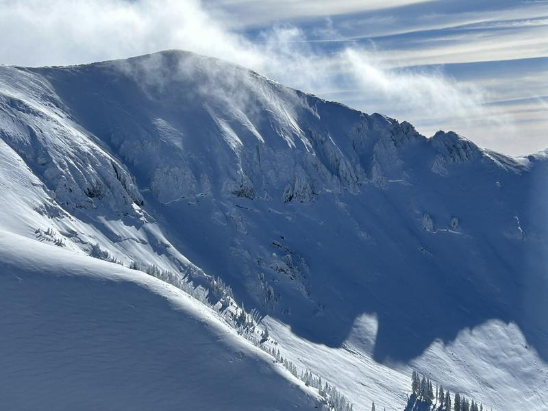
This massive avalanche on a NW aspect in Talking Mt. Cirque ran deep and wide failing on the buried facets that formed in November.
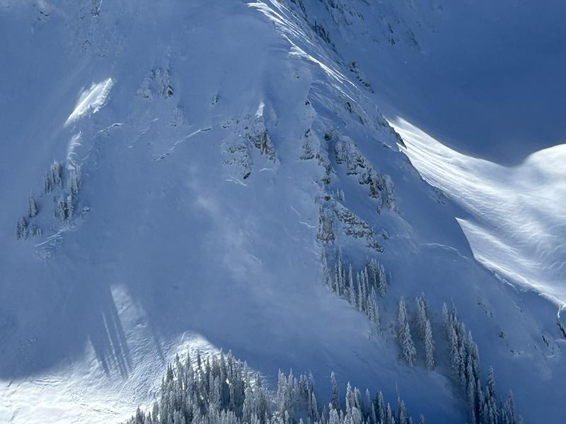
This very large avalanche occurred on a NE face in Talking Mt. Cirque and connected around the ridge into Lone Pine. Both of these photos show how well connected the slab is, resulting in very wide avalanches connecting across ridge lines and over rocky terrain features.
Several other avalanches were observed yesterday. We saw avalanches that failed deep on the buried PWL, Loose Dry Avalanches that ran in steep terrain, and slabs of Wind Drifted snow that failed within the recent storm snow. To view more photos of recent avalanches see my fieldwork from yesterday.
Ad
Avalanche Problem #1
Persistent Weak Layer
Type
Location
Likelihood
Size
Description
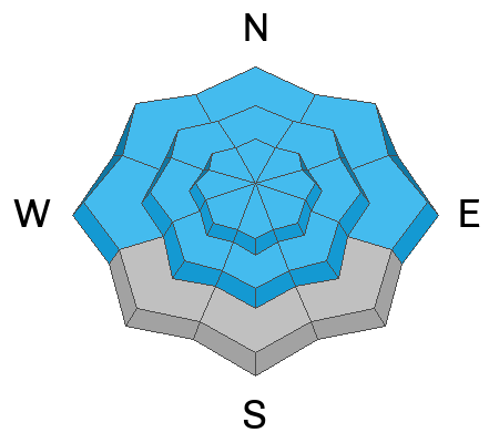
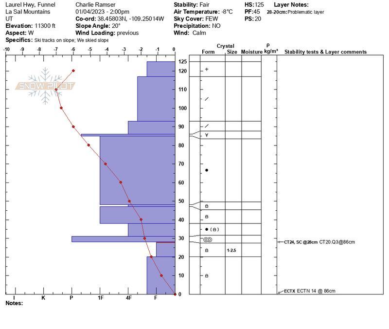
Heavy snowfall over the past week has been a good test for the persistent weak layer (PWL) of faceted snow that developed during the cold dry period in mid November. This weak layer exists on all aspects and has produced another round of several large natural avalanches near treeline and above on slopes that face NW-N-NE. These are the biggest avalanches we have seen this season. And getting caught in this kind of avalanche would be fatal. While stability tests may being showing signs that the weak layer is gaining strength, the recent round of natural activity suggests the weak layer is still hanging in the balance and needs more time to heal. Now is not the time to be getting onto big steep slopes. Deep and dangerous human triggered avalanches remain likely. The snowpack simply needs more time to adjust after such a big loading event. Slopes steeper than 30 degrees should be avoided.
Avalanche Problem #2
Wind Drifted Snow
Type
Location
Likelihood
Size
Description
SW winds will be on the increase today and blow 20-25 mph by this afternoon. There is plenty of cold dry powder available for transport. Observers yesterday reported moderate snow transport and you can expect to find fresh slabs of wind drifted snow on all aspects above treeline. Be on the lookout for fat rounded pillows of wind drifted snow on the lee side of exposed ridges and in and around terrain features. Watch for and avoid drifts on gully walls, under cliff bands, along sub-ridges, in scoops, saddles, and sinks.
Yesterday a natural avalanche was observed on a NE aspect above treeline where a fresh slab of wind drifted snow overloaded and ran within the recent storm snow. This type of avalanche remains a possibility today.
Additional Information
Check out this detailed snow profile from Charlie Ramser and Maggie Nielson from their travels yesterday.
General Announcements
This forecast is from the U.S.D.A. Forest Service, which is solely responsible for its content. This forecast describes general avalanche conditions and local variations always occur. This forecast will be updated by 7:30 tomorrow morning.