Join us for the 33rd Backcountry Benefit - Get Your Tickets Now!

Forecast for the Moab Area Mountains

Eric Trenbeath
Issued by Eric Trenbeath on
Sunday morning, January 25, 2026

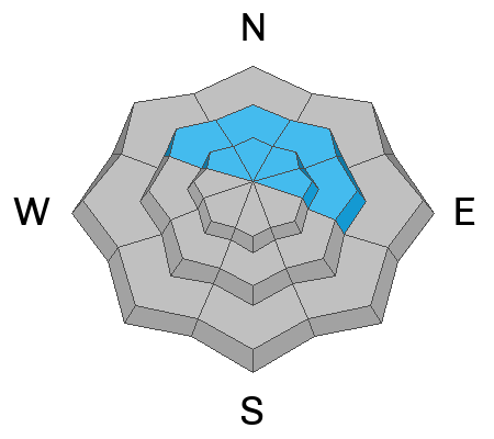
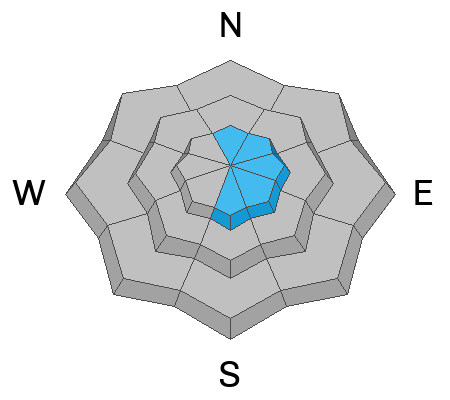
An increase in winds have kept the avalanche danger at CONSIDERABLE on steep slopes near and above tree line that face N-NE-E. In these areas, human triggered avalanches involving slabs of wind drifted snow are likely. Triggered wind slabs have the potential to step down into a buried persistent weak layer causing a deeper and much more dangerous avalanche. This is also possible on slopes facing NW. Slopes steeper than 30 degrees should be avoided in these areas.

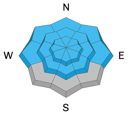
A MODERATE danger can be found on most all other aspects and elevations that have more than about 8-10 inches of new snow. Look for areas where the wind has thickened the most recent storm snow into a slab and avoid areas that have smooth, rounded deposits of wind drifted snow. Cracking in the snow surface is a sign of instability. Utilize test slopes to see how the new snow is behaving before committing to steeper terrain.

Low
Moderate
Considerable
High
Extreme
Learn how to read the forecast here
Special Announcements

Geyser Pass Road Conditions: The road has not been plowed and it is a mess. 4x4 required.

Grooming: LUNA groomed all trails yesterday but they saw a lot of traffic.

We are looking to reschedule our Moab Backcountry 101 Class to February 20, 21 in the hopes that we will have more snow. Click here for information and registration. Moab and Monticello locals can use the discount code MOAB-LOCAL for a 10% discount.

Weather and Snow

24 Hour Snow: 0" 72 Hour Snow: 8" Season Total Snow: 44" Depth at Gold Basin: 30"

Winds on Pre-Laurel Peak: NW 20-25 G 30 Temp: 2°F

Weather

Uncle gusty has returned and it's a bone chilling 2°F at 10,000 feet. A shortwave trough on a northwest flow will produce strong, northwest winds today followed by a very cold air mass. Under sunny skies, high temperatures today will slowly creep up into the low to mid teens. Winds should begin to taper off tonight and temperatures will again crash to near 0°F. Temperatures begin to rebound on Monday as high pressure and dry, northwest flow return.

General Conditions

Low tide notwithstanding, conditions were quite good in the mountains yesterday and it was great to see everyone out enjoying them. And many thanks to all who sent in observations. Unfortunately, the return of Uncle Gusty may put a damper on the powder party today. Neither myself, nor observers found a real slab in the recent storm snow yesterday but winds today may thicken it up a bit as well as redistribute it. The new snow is also sitting on top of a recently formed faceted layer adding to our already poor snowpack structure. More on that in the video below.

See recent observations here.

Snowpack and Weather Data

Gold Basin SNOTEL site (10,000')
SNOTEL site near Geyser Pass Winter Trailhead (9600')
Wind Station on Pre-Laurel Peak (11,400')
NWS forecast for the La Sal Mountains.
Recent Avalanches
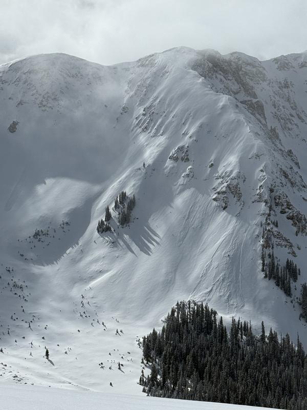
Chris Benson observed this avalanche within the recent storm snow. First reported as dry loose, closer inspection by him revealed flanks and a crown indicative of a soft slab avalanche. See his observation for more details.
Click here for the complete avalanche database.
Avalanche Problem #1
Persistent Weak Layer
Type
Location
Likelihood
Size
Description

The most dangerous problem you will encounter out there is the possibility of a deep and dangerous avalanche failing on a buried persistent weak layer. You are most likely to encounter this on steep slopes near and above tree line that face NW-N-NE-E with the highest likelihood on N-NE-E aspects. The recent snow didn't appear to contain enough water weight to tip the scales but wind loading may do it. This is exactly what happened in the case of the large, snowmobile triggered avalanche in Dark Canyon on January 9.

If you've been following along by now you know we have a very poor snowpack structure where the pack is faceted entirely through. The Dark Canyon avalanche failed on facets beneath the Christmas Rain Crust (CRC), and we now have a new faceted layer to be concerned with immediately beneath the recent snow (see recent observations from myself, Chris Benson, and Travis Nauman). This layer is a bit tricky in that it hasn't formed everywhere. The last stretch of high pressure also saw a lot of wind from the northwest so many snow surfaces were crusted or blasted into hard wind board. This new faceted layer only formed in areas protected from the northwest winds. Slopes near tree line with an easterly component to their aspect are the most suspect. An avalanche failing on this layer could step down below the CRC and take out the entire season's snowpack.

Avalanche Problem #2
Wind Drifted Snow
Type
Location
Likelihood
Size
Description

Winds from the northwest will blow and drift snow on to slopes facing the east half of the compass today. Look for fresh drifting on the leeward sides of ridge crests and terrain features in exposed terrain. Fresh drifts are often recognizable by their smooth, rounded appearance and cracking is a sign of instability. The most dangerous slopes will be those facing N-NE-E. In these areas, human triggered wind slab avalanches may step down to a buried persistent weak layer causing a deeper and much more dangerous avalanche.

Avalanche Problem #3
New Snow
Type
Location
Likelihood
Size
Description

Avalanches involving the recent snow will be possible on nearly all aspects and elevations today. Although we didn't find a slab in the recent storm snow yesterday, strong winds from the northwest today may thicken it into a slab. Pay attention to how the snow is behaving before committing to steeper terrain. Look for signs of "slabiness" such as blocks of snow between your skis or cracking in the snow surface, and avoid areas with recent deposits of wind drifted snow. Utilize test slopes or make "slope cuts" before you commit. Practice safe travel techniques such as skiing or riding slopes one at a time and move to a safe location at the bottom.

Additional Information
General Announcements
This forecast is from the U.S.D.A. Forest Service, which is solely responsible for its content. This forecast describes general avalanche conditions and local variations always occur.