Join us for the 33rd Backcountry Benefit - Get Your Tickets Now!

Forecast for the Moab Area Mountains

Dave Garcia
Issued by Dave Garcia on
Thursday morning, January 22, 2026

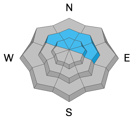
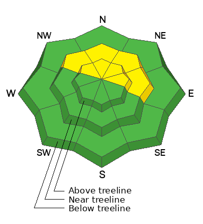
While the odds of triggering an avalanche are decreasing, a MODERATE danger remains for human-triggered hard slab avalanches failing on a deeply buried persistent weak layer. This problem exists on all steep slopes near treeline and above that face NW through E, with the greatest concern on north and east aspects. Avalanches breaking on this layer would be 2 to 5 feet deep and could propagate widely. The simplest way to avoid this problem is to stick to slopes less than 30 degrees.
Low
Moderate
Considerable
High
Extreme
Learn how to read the forecast here
Special Announcements

Geyser Pass Road Conditions: The road is mostly dry dirt up to the Trans La Sal TH with patches of ice and packed snow above.

Grooming: Geyser Pass was groomed on Saturday.

We are looking to reschedule our Moab Backcountry 101 Class to February 20, 21 in the hopes that we will have more snow. Click here for information and registration. Moab and Monticello locals can use the discount code MOAB-LOCAL for a 10% discount.

Weather and Snow

24 Hour Snow: 0" 72 Hour Snow: 0" Season Total Snow: 36" Depth at Gold Basin: 22"

Winds on Pre-Laurel Peak: W 5-10 Temp: 20°F

Weather

Under broken skies, it is 20°F in Gold Basin this morning. Today, winds blow from the west at 5-10 MPH. Skies will be mostly sunny, and high temperatures will reach 33°F at 10,000 feet. Expect increasing cloud cover late this afternoon ahead of an incoming storm. Light precipitation begins after midnight and continues on Friday. Precipitation intensifies Friday night, peaking into early Saturday morning. This looks like a decent refresh for the mountains, and when it's all said and done, we should pick up 4 to 6 inches of snow. The storm will also bring colder temperatures to our region, and daytime highs this weekend will be near 20°F with lows in the single digits.

General Conditions

Yesterday, I toured around the north side of Haystack Peak. I found heavily wind-damaged snow and very poor ski conditions overall. It is getting really difficult to find any soft turns right now, and the weekend storm will provide a much-needed refresh. Skiing and riding conditions will improve by Saturday and Sunday.

The general setup is hard wind slabs above a mostly faceted snowpack to the ground. We still have concerns about the weak facets beneath the Christmas rain crust. It remains possible for skiers and riders to trigger deep, hard slab avalanches near and above treeline where this poor structure exists. When considering the low reward for dropping into big north faces right now, it doesn't seem worth the risk. However, many slopes offer low danger, allowing for peak bagging and good sightseeing with one more sunny day on tap.

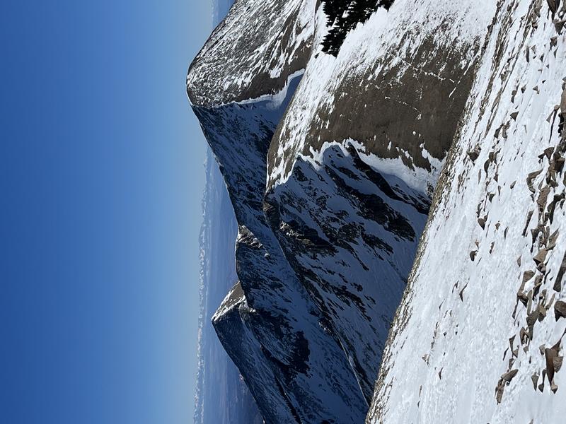
Looking out towards a heavily scoured Mt. Tomasaki. (Nate Ament Photo)

Snowpack and Weather Data

Gold Basin SNOTEL site (10,000')
SNOTEL site near Geyser Pass Winter Trailhead (9600')
Wind Station on Pre-Laurel Peak (11,400')
NWS forecast for the La Sal Mountains.
Recent Avalanches
It's been more than a week since a large snowmobile-triggered avalanche occurred on the East Face of Laurel Peak in Dark Canyon. Although the odds are decreasing, this type of avalanche remains possible. See the report here.
Click here for the complete avalanche database.
Avalanche Problem #1
Persistent Weak Layer
Type
Location
Likelihood
Size
Description

The snowpack still has a poor structure and has proven it can produce large and destructive human-triggered avalanches. While the likelihood of triggering one is decreasing, the consequences remain high. Any avalanche failing on this persistent weak layer would likely break to the ground, taking out the entire season’s snowpack, and could result in a season-ending injury—or worse. This is a classic persistent weak layer problem. It’s not going away on its own, and it will take a substantial amount of new snow to ever put it to bed.

The base of the snowpack continues to weaken, consisting of large-grained facets and depth hoar. The primary weak layer of concern sits just below the Christmas rain crust. In some areas, this crust may feel supportive under your skis or board, but its ability to bridge the weak snow below is highly variable and unreliable. Don’t let a lack of obvious red flags lull you into a false sense of security.

If you’re traveling in avalanche terrain, start with small, low-consequence features. Avoid steep convexities, terrain traps, thin rocky areas, and slab margins. The most effective way to manage this problem is to avoid it entirely by sticking to slopes less than 30 degrees

Additional Information
General Announcements
This forecast is from the U.S.D.A. Forest Service, which is solely responsible for its content. This forecast describes general avalanche conditions and local variations always occur.