Forecast for the Moab Area Mountains

Eric Trenbeath
Issued by Eric Trenbeath on
Friday morning, January 23, 2026

A storm is on our doorstep. We shouldn't see much of a rise in danger today, but be alert to changing conditions and expect a potential rise in avalanche danger over the next 24 hours. If we get more snow than expected today, be on the lookout for fresh deposits of wind drifted snow along upper elevation ridge crests, and avoid steep slopes that have more than about 8 inches of new snow.

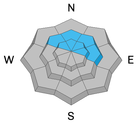
While the odds of triggering a large avalanche failing on a buried persistent weak layer have decreased, an isolated or MODERATE danger remains. This problem exists on all steep slopes near treeline and above that face NW through E, with the greatest concern on north and east aspects. Avalanches breaking on this layer would be 2 to 5 feet deep and could propagate widely. The simplest way to avoid this problem is to stick to slopes less than 30 degrees.

Low
Moderate
Considerable
High
Extreme
Learn how to read the forecast here
Special Announcements

Geyser Pass Road Conditions: The road is mostly dry dirt up to the Trans La Sal TH with patches of ice and packed snow above.

Grooming: Geyser Pass was groomed on Saturday.

We are looking to reschedule our Moab Backcountry 101 Class to February 20, 21 in the hopes that we will have more snow. Click here for information and registration. Moab and Monticello locals can use the discount code MOAB-LOCAL for a 10% discount.

Weather and Snow

24 Hour Snow: 0" 72 Hour Snow: 0" Season Total Snow: 36" Depth at Gold Basin: 22"

Winds on Pre-Laurel Peak: WSW 10-15 G 20 Temp: 30°F

Weather

A closed low moving in off the coast of Southern California is pushing moisture into the region on a southwest flow. As this moisture moves northeast, it meets an upper-level trough and surface cold front bringing snow to the mountains of Southeast Utah and Southwestern Colorado by mid-day today. We should see a couple inches of accumulation this afternoon with the bulk of the precipitation falling tonight. 5-7 inches are possible by Saturday morning. Winds blowing from the southwest should be pretty well behaved averaging 10-15 mph along ridge tops with gusting to 20. We've seen our high for the day. Look for decreasing temperatures as the cold front moves in with temperatures dropping into the mid teens overnight. We'll see lingering chances for snow on Saturday with a wind shift to the northwest as the storm leaves the area. Skies should be mostly cloudy, and high temperatures will be in the mid to upper teens. As skies clear by Saturday night, temperatures drop into the single digits. Dry air returns on Sunday.

General Conditions

By now you are well aware of the state of conditions after nearly three weeks of no snow, strong winds, sun and warm temperatures. Let's hope for a nice refresh to our tired and worn snow surface.

From an avalanche perspective, be alert to changing conditions and a rising danger if we get more snow than expected today. Look for fresh deposits of wind drifted snow along the leeward sides of upper elevation ridge crests and terrain features and avoid steep slopes that have more than about 8 inches of wind drifted snow.

Although the likelihood has diminished, we still have concerns over the potential for deep avalanches failing on a buried persistent weak layer. This is a low probability, high consequence situation but the poor snowpack structure is hard to ignore. In general, we are concerned about northerly aspects near and above tree line where stiff slabs of wind drifted snow exist over top of a snowpack that is weak, and faceted through to the ground. More on that below.

See recent observations here.

Snowpack and Weather Data

Gold Basin SNOTEL site (10,000')
SNOTEL site near Geyser Pass Winter Trailhead (9600')
Wind Station on Pre-Laurel Peak (11,400')
NWS forecast for the La Sal Mountains.
Recent Avalanches
Click here for the complete avalanche database.
Avalanche Problem #1
Persistent Weak Layer
Type
Location
Likelihood
Size
Description

The snowpack still has a poor structure and has proven it can produce large and destructive human-triggered avalanches. While the likelihood of triggering one has decreased significantly, the consequences remain high. Any avalanche failing on this persistent weak layer would likely break to the ground, taking out the entire season’s snowpack, and could result in a season-ending injury—or worse. This is a classic persistent weak layer problem. It’s not going away on its own, and it will take a substantial amount of new snow to ever put it to bed.

The base of the snowpack continues to weaken, consisting of large-grained facets and depth hoar. The primary weak layer of concern sits just below the Christmas rain crust. In some areas, this crust may feel supportive under your skis or board, but its ability to bridge the weak snow below is highly variable and unreliable. Don’t let a lack of obvious red flags lull you into a false sense of security.

If you’re traveling in avalanche terrain, start with small, low-consequence features. Avoid steep convexities, terrain traps, thin rocky areas, and slab margins. The most effective way to manage this problem is to avoid it entirely by sticking to slopes less than 30 degrees

Additional Information
General Announcements
This forecast is from the U.S.D.A. Forest Service, which is solely responsible for its content. This forecast describes general avalanche conditions and local variations always occur.