Forecast for the Moab Area Mountains

Eric Trenbeath
Issued by Eric Trenbeath for
Friday, January 18, 2019
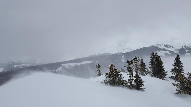
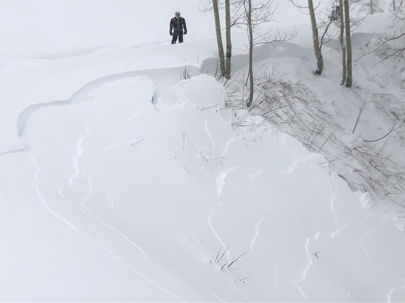
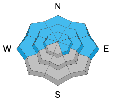
HEAVY SNOWFALL AND STRONG WINDS HAVE CREATED DANGEROUS AVALANCHE CONDITIONS! The avalanche danger is HIGH today! New and wind drifted snow has dangerously overloaded a fragile snowpack. Human triggered avalanches breaking 2'-4' deep are likely on steep slopes that face W-N-E, and natural avalanches are possible. Avalanches involving new and wind drifted snow are possible on all aspects. Travel in avalanche terrain is not recommended. Backcountry travelers need to possess excellent route finding skills and know how to stay off of, and out from under, steep, avalanche prone terrain. DANGEROUS CONDITIONS WILL PERSIST THROUGH THE WEEKEND!
Low
Moderate
Considerable
High
Extreme
Learn how to read the forecast here
Avalanche Warning
THE FOREST SERVICE UTAH AVALANCHE CENTER IN MOAB HAS ISSUED A BACKCOUNTRY AVALANCHE WARNING.
* TIMING... 6 AM MST FRIDAY THROUGH 6 AM MST SATURDAY.
* AFFECTED AREA...FOR THE LA SAL AND ABAJO MOUNTAINS OF SOUTHEASTERN UTAH
* AVALANCHE DANGER...THE AVALANCHE DANGER HAS RISEN TO HIGH.
* REASON/IMPACTS...RECENT HEAVY SNOW COMBINED WITH WIND HAS CREATED WIDESPREAD AREAS OF UNSTABLE SNOW AND DANGEROUS AVALANCHE CONDITIONS. BOTH HUMAN TRIGGERED AND NATURAL AVALANCHES ARE LIKELY. STAY OFF OF AND OUT FROM UNDER SLOPES STEEPER THAN 30 DEGREES. AVOID TRAVEL IN AVALANCHE TERRAIN. CONDITIONS WILL REMAIN DANGEROUS THROUGH THE WEEKEND.
Special Announcements
Grand County plowed yesterday and will not be back up for the weekend. Expect 4"-6" of new snow on the road with possible drifting. 4wd required.
We will be offering a Backcountry 101 avalanche course on Feb 8, 9. It's a great way to up your avalanche knowledge with both classroom, and hands on field instruction. Click here for more details and to register. Much thanks to Moab Gear Trader for sponsoring this course! Please visit them for all of your winter backcountry needs.
Weather and Snow
Last night's storm brought an additional 6" of new snow, a bit underwhelming considering what was forecasted, but combined with Wednesday's totals we've received 18" of snow with about 2" of water weight this week. Not too shabby! Moderate to strong, gusty SW winds blew most of the day yesterday and into last night. They shifted to the WNW early this morning and are averaging 20-25 mph along ridge tops with gusts into the 30's. Skies should clear out today and we'll continue to see moderate but blustery NW winds. High temps will be in the low 20's.
Reports from the backcountry yesterday were of wild and sensiitve conditions, with blowing and drifting snow, widespread collapsing and shooting cracks, and sled triggered avalanching of road banks up to 3' deep. Check out this observation from Travis Nauman. Make no mistake, things are dangerous out there!
Wild and windy conditions yesterday! Travis Nauman photo.
Base depth in Gold Basin: 53"
New snow totals in Gold Basin (10,000')
Snow totals at the Geyser Pass Trailhead (9600')
Wind, temperature, and humidity on Pre Laurel Peak (11,700')
National Weather Service point forecast.
Recent Avalanches
In our travels Wednesday we observed natural avalanches on Exxon's Folley and on Noriega's Face. A large avalanche at the head of Dory Canyon near Corkscrew Glades has also been reported. See our avalanche list for details.
State Parks ranger Jeff Arbon was snomobiling on the east side of the range yesterday and reported sensitive, unstable conditions. Road cuts, and steep banks were collapsing and avalanching easily under their weight.
Ad
Avalanche Problem #1
Persistent Weak Layer
Type
Location
Likelihood
Size
Description
18" of new snow with 2" of water weight has dangerously overloaded persistent weak layers in the snowpack, and human triggered avalanches 2'-4' deep are likely, if not certain on steep slopes facing W-N-E. With widespread collapsing of the snowpack, remote triggering may also be a possibility. Stay off of, and out from under steep terrain, and give run out zones a wide berth.
Avalanche Problem #2
Wind Drifted Snow
Type
Location
Likelihood
Size
Description
Blowing and drifting snow has exacerbated the danger and deep fresh wind drifts have helped to overload a weak and fragile snowpack. Avoid steep slopes that have recent deposits of wind drifted snow. On slopes that face W-N-E, wind drifted snow will increase the likelihood for avalanches to step down to a buried persistent weak layer and avalanches 2'-4' deep are likely.
Avalanche Problem #3
New Snow
Type
Location
Likelihood
Size
Description
Avalanching within the new snow will be possible on steep slopes on all aspects, both in the form of loose snow sluffs or as cohesive soft slabs.
General Announcements
Your information can save lives. If you see anything we should know about, please help us out by submitting snow and avalanche observations HERE. You can also call me at 801-647-8896, or send me an email: [email protected].
Support the UAC through your daily shopping. When you shop at Smith's, or online at REI, Backcountry.com, Patagonia, NRS, Amazon, eBay by clicking on these links, they donate a portion of your purchase to the UAC. If you sell on eBay, you can have your See our Affiliate Page for more details on how you can support the UAC when you shop
This advisory is from the U.S.D.A. Forest Service, which is solely responsible for its content. This advisory describes general avalanche conditions and local variations always occur.