Forecast for the Moab Area Mountains

Eric Trenbeath
Issued by Eric Trenbeath for
Thursday, January 17, 2019
DANGEROUS AVALANCHE CONDITIONS WILL EXIST FOR THE NEXT SEVERAL DAYS! The avalanche danger is HIGH today as new snow and wind drifted are dangerously overloading a fragile snowpack. Natural and human triggered avalanches breaking 2'-4' deep are likely on steep slopes that face W-N-E. Avalanches within the most recent snow are possible on all aspects. Travel in avalanche terrain is not recommended. Backcountry travelers need to possess excellent route finding skills and know how to stay off of, and out from under, steep, avalanche prone terrain.
Low
Moderate
Considerable
High
Extreme
Learn how to read the forecast here
Avalanche Warning
THE FOREST SERVICE UTAH AVALANCHE CENTER IN MOAB HAS ISSUED A BACKCOUNTRY AVALANCHE WARNING.
* TIMING... 6 AM MST THURSDAY THROUGH 6 AM MST FRIDAY.
* AFFECTED AREA...FOR THE LA SAL AND ABAJO MOUNTAINS OF SOUTHEASTERN UTAH
* AVALANCHE DANGER...THE AVALANCHE DANGER HAS RISEN TO HIGH.
* REASON/IMPACTS...RECENT SNOW COMBINED WITH HEAVY SNOW EXPECTED LATER TODAY WILL LIKELY CREATE WIDESPREAD AREAS OF UNSTABLE SNOW AND DANGEROUS AVALANCHE CONDITIONS. BOTH HUMAN TRIGGERED AND NATURAL AVALANCHES WILL BE LIKELY. STAY OFF OF AND OUT FROM UNDER SLOPES STEEPER THAN 30 DEGREES.
Special Announcements
Grand County will be plowing today mid morning and the gate will be closed while plowing is in progress. They do not plan to plow after tonight's storm so we will be on our own for the weekend.
We will be offering a Backcountry 101 avalanche course on Feb 8, 9. It's a great way to up your avalanche knowledge with both classroom, and hands on field instruction. Click here for more details and to register.
We've installed an avalanche beacon tester and a beacon training park at the Geyser Pass Trailhead! Be sure you are beeping and practice your rescue skills!
Thanks to UAC volunteer Ed Grote, ex La Sal forecaster Max Forgensi, and LUNA volunteer Matt Hebberd for helping out with this. You guys rock!
The new UAC IOS mobile app is now available on the app store. Check out the new "My Weather" feature.
Check out the new free online avalanche course series developed by the Utah Avalanche Center. This is a great way to refresh your skills or prepare you for a Backcountry 101 or Level 1 class.
Weather and Snow
In a repeat performance of our last storm, 12" of dense, heavy snow fell in the La Sals Tues night into Wed morning. Moderate to strong southerly winds accompanied most of the snowfall, but then they tapered off and were pretty well behaved most of the day yesterday. They are currerntly blowing in the 15-25 mph range. Temps are in the low 20's. Today, look for increasing SW winds ahead of the next storm system approaching our area. Snowfall should begin this afternoon with the heaviest period coming in tonight. 12"-18" are possible.
It was a misty, maritime kind of day in the mountains yesterday. The new snow formed a dense, cohesive slab on all aspects. Collapsing and cracking in the snow surface was widespread, and "slabby" conditions were rampant.
Base depth in Gold Basin: 47"
New snow totals in Gold Basin (10,000')
Snow totals at the Geyser Pass Trailhead (9600')
Wind, temperature, and humidity on Pre Laurel Peak (11,700')
National Weather Service point forecast.
Recent Avalanches
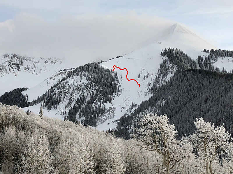
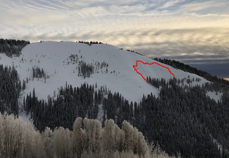
When the weather cleared yesterday afternoon we were able to observe natural avalanches on Exxon's Folley and on the west end of Noriega's Face. The Exxon's slide definitely appeared to have stepped down to a buried weak layer. Noriega's was unclear.
Exxon's Folley
Noriega's Face
Ad
Avalanche Problem #1
Persistent Weak Layer
Type
Location
Likelihood
Size
Description
Though new snow will be the most immediate threat, the greatest danger will come from new and drifting snow adding additional stress to reactive, persistent weak layers in the snowpack. These layers of loose, sugary faceted snow can be found at the bottom of the Christmas storm, as well as on top of the October crust. Both layers are proving to be reactive in stability tests and the new snow will make a bad situation worse. Stay off of, and out from under steep terrain that faces W-N-NE where human triggered avalanches 2'-4' deep are likely.
Avalanche Problem #2
Wind Drifted Snow
Type
Location
Likelihood
Size
Description
Blowing and drifting snow will exacerbate the danger today as fresh wind drifts overload a weak and fragile snowpack. Avoid steep slopes that have recent deposits of wind drifted snow. On slopes that face W-N-E, wind drifted snow will increase the likelihood for avalanches to step down to a buried persistent weak layer and avalanches 2'-4' deep are likely.
Avalanche Problem #3
New Snow
Type
Location
Likelihood
Size
Description
The most recent snow has formed a dense, cohesive slab on all aspects. Cracking and collapsing are sure signs of instabilty. Also look for dense blocks between ski cuts indicating that a slab is present. Avoid steep slopes on all aspects where you can detect slabs within the most recent snow.
General Announcements
Your information can save lives. If you see anything we should know about, please help us out by submitting snow and avalanche observations HERE. You can also call me at 801-647-8896, or send me an email: [email protected].
Support the UAC through your daily shopping. When you shop at Smith's, or online at REI, Backcountry.com, Patagonia, NRS, Amazon, eBay by clicking on these links, they donate a portion of your purchase to the UAC. If you sell on eBay, you can have your See our Affiliate Page for more details on how you can support the UAC when you shop
This advisory is from the U.S.D.A. Forest Service, which is solely responsible for its content. This advisory describes general avalanche conditions and local variations always occur.