Forecast for the Moab Area Mountains

Eric Trenbeath
Issued by Eric Trenbeath for
Wednesday, January 16, 2019
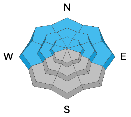
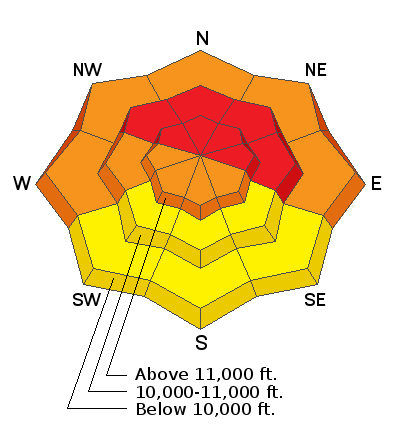
DANGEROUS AVALANCHE CONDITIONS WILL EXIST FOR THE NEXT SEVERAL DAYS! The avalanche danger is HIGH today as new snow and wind drifted are dangerously overloading a fragile snowpack. Natural and human triggered avalanches breaking 2'-4' deep are likely on steep slopes that face NW-N-E. The danger will be greatest in wind exposed terrain above tree line but could extend down into areas below. The danger will become more widespread by Thursday, and extend into the weekend. Backcountry travelers need to possess excellent route finding skills and know how to stay off of, and out from under, steep, avalanche prone terrain.
Low
Moderate
Considerable
High
Extreme
Learn how to read the forecast here
Special Announcements
We will be offering a Backcountry 101 avalanche course on Feb 8, 9. It's a great way to up your avalanche knowledge with both classroom, and hands on field instruction. Click here for more details and to register.
We've installed an avalanche beacon tester and a beacon training park at the Geyser Pass Trailhead! Be sure you are beeping and practice your rescue skills!
Thanks to UAC volunteer Ed Grote, ex La Sal forecaster Max Forgensi, and LUNA volunteer Matt Hebberd for helping out with this. You guys rock!
The new UAC IOS mobile app is now available on the app store. Check out the new "My Weather" feature.
Check out the new free online avalanche course series developed by the Utah Avalanche Center. This is a great way to refresh your skills or prepare you for a Backcountry 101 or Level 1 class.
Weather and Snow
About 8" of new snow has fallen in Gold Basin and light snow continues to fall. Moderate to strong SE winds blew yesterday evening and into the nigh. They've since swung around to the SW and have backed off into the 10-15 mph range with gusts to 25. Light snow will continue through about noon with another 3"-5" possible. We'll see breezy westerly winds, with gusts into the 30's along ridge tops. High temps will be in the mid 20's. Things will begin to dry out this afternoon before the next storm moves into the area on Thursday.
Though snow conditions will be good today, it's going to be dangerous out there, and sticking to low angle wind sheltered terrain will be imperative.
Base depth in Gold Basin: 47"
New snow totals in Gold Basin (10,000')
Snow totals at the Geyser Pass Trailhead (9600')
Wind, temperature, and humidity on Pre Laurel Peak (11,700')
National Weather Service point forecast.
Ad
Avalanche Problem #1
Persistent Weak Layer
Type
Location
Likelihood
Size
Description
The immediate threat will come from new and drifting snow adding additional stress to buried, persistent weak layers in the snowpack. These layers of loose, sugary faceted snow can be found at the bottom of the Christmas storm, as well as on top of the October crust. Both layers are proving to be reactive in stability tests and the new snow will make a bad situation worse. Stay off of, and out from under steep terrain that faces W-N-NE where human triggered avalanches 2'-4' deep are likely.
Avalanche Problem #2
Wind Drifted Snow
Type
Location
Likelihood
Size
Description
Blowing and drifting snow will exacerbate the danger today as fresh wind drifts overload a weak and fragile snowpack. Avoid steep slopes that have recent deposits of wind drifted snow. On slopes that face W-N-E, wind drifted snow will increase the likelihood for avalanches to step down to a buried persistent weak layer.
Avalanche Problem #3
New Snow
Type
Location
Likelihood
Size
Description
We may see avalanching within the storm snow today, both as loose snow sluffs, and as soft cohesive slabs. Look for cracking in the snow surface and for loose sluffs running off of steep terrain features as signs of instability. Travel advice remains the same. Stay off of and out from under steep slopes, especially when in terrain that faces NW-N-E.
General Announcements
Your information can save lives. If you see anything we should know about, please help us out by submitting snow and avalanche observations HERE. You can also call me at 801-647-8896, or send me an email: [email protected].
Support the UAC through your daily shopping. When you shop at Smith's, or online at REI, Backcountry.com, Patagonia, NRS, Amazon, eBay by clicking on these links, they donate a portion of your purchase to the UAC. If you sell on eBay, you can have your See our Affiliate Page for more details on how you can support the UAC when you shop
This advisory is from the U.S.D.A. Forest Service, which is solely responsible for its content. This advisory describes general avalanche conditions and local variations always occur.