Forecast for the Moab Area Mountains

Eric Trenbeath
Issued by Eric Trenbeath for
Saturday, January 19, 2019
HEAVY SNOWFALL AND STRONG WINDS THIS WEEK HAVE CREATED DANGEROUS AVALANCHE CONDITIONS! The avalanche danger remains HIGH in upper elevation, wind exposed terrain. Deep and dangerous, human triggered avalanches are likely on steep, wind drifted slopes, especially on those slopes facing W-N-E. Out of the wind zone, the danger remains CONSIDERABLE. Backcountry travelers need to possess excellent route finding skills and know how to stay off of, and out from under, steep, avalanche prone terrain.
Low
Moderate
Considerable
High
Extreme
Learn how to read the forecast here
Special Announcements
We are sorry to report that a search is resuming this morning for a skier buried in a large avalanche around 5 pm yesterday by Electric Lake, on the Manti/Skyline Plateau. The skier is not wearing a beacon. Here is the preliminary accident report.
Grand County has not plowed since the most recent storm Thursday night. 4"-6" of rutted and drifted snow exists on the road but numerous vehicles made it up yesterday. 4wd required.
We will be offering a Backcountry 101 avalanche course on Feb 8, 9. It's a great way to up your avalanche knowledge with both classroom, and hands on field instruction. Click here for more details and to register. Much thanks to Moab Gear Trader for sponsoring this course! Please visit them for all of your winter backcountry needs.
Weather and Snow
Skies will clear today and we'll have a good look around the mountains after a stormy few days. Ridge top winds are currently blowing out of the WNW averaging 10-15 mph, and temps are in the single digits. High temps today at 10,000' will be in the low 20's, but continued breezy, NW winds will keep the chill on. Sundy will be similar but with winds shifting to the SW ahead of the next storm currently on track for Monday.
Snow total since Tues night is 18" with around 2" of water weight. A pretty good load for our fragile snowpack. Winds from all directions have blown, drifted, and jacked the snow surface in upper elevation, wind exposed terrain. The best quality, and safest snow conditions will be found on low angle, wind sheltered terrain. Base depth in Gold Basin is 54" and we are now at 108% of normal!
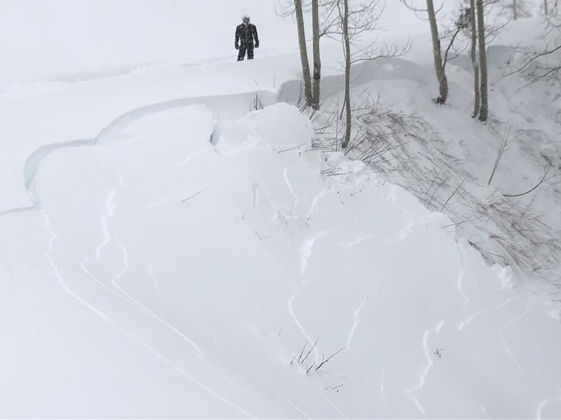
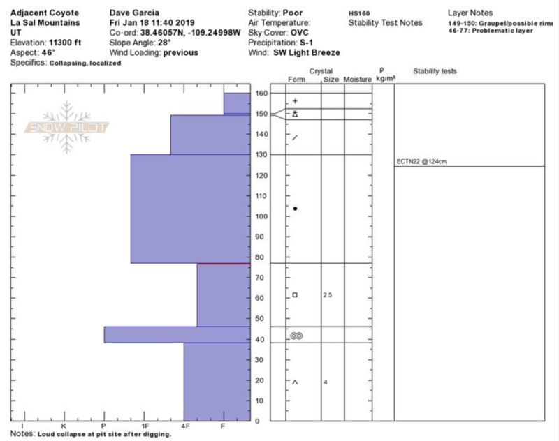
Dave Garcia and company were out yesterday and sent in this observation.
Base depth in Gold Basin: 53"
New snow totals in Gold Basin (10,000')
Snow totals at the Geyser Pass Trailhead (9600')
Wind, temperature, and humidity on Pre Laurel Peak (11,700')
National Weather Service point forecast.
Recent Avalanches
It's been an active week for avalanche activity. On Wednesday we observed natural avalanches on Exxon's Folley and on Noriega's Face. A large avalanche at the head of Dory Canyon near Corkscrew Glades was also been reported. In their travels yesterday, Dave Garcia and company reported slides from near Pinto Glades, and in Gold Basin.
State Parks ranger Jeff Arbon was snomobiling on the east side of the range Thursday when conditions were quite sensitive. Road cuts, and steep banks were collapsing and avalanching easily under their weight.
Ad
Avalanche Problem #1
Persistent Weak Layer
Type
Location
Likelihood
Size
Description
18" of new snow with 2" of water weight has dangerously overloaded persistent weak layers in the snowpack, and human triggered avalanches 2'-4' deep are likely, if not certain on steep slopes facing W-N-E. Stay off of steep slopes with these aspects. Nuff said?
Dave Garcia's pit profile from a NE aspect at 11,400' illustrates a layer of weak faceted snow between 45 and 75 cms. This snow fell the first weekend of December, and is sitting on top of the October crust. Denser snow above this faceted layer started coming in on Christmas Eve, followed by storms on New Year's Eve, Jan 6-7, and this week.
Avalanche Problem #2
Wind Drifted Snow
Type
Location
Likelihood
Size
Description
Blowing and drifting snow has exacerbated the danger and deep fresh wind drifts have helped to overload a weak and fragile snowpack. During the storm cycle, SW winds loaded slopes facing NW-N-E. In these areas, wind drifted snow has increased the likelihood for triggering avalanches 2'-4' deep on a buried persistent weak layer. Yesterday, winds shifted to the NW and blew snow the opposite direction on to southerly facing aspects. Bottom line - avoid any steep slope that has recent deposits of wind drifted snow.
General Announcements
Your information can save lives. If you see anything we should know about, please help us out by submitting snow and avalanche observations HERE. You can also call me at 801-647-8896, or send me an email: [email protected].
Support the UAC through your daily shopping. When you shop at Smith's, or online at REI, Backcountry.com, Patagonia, NRS, Amazon, eBay by clicking on these links, they donate a portion of your purchase to the UAC. If you sell on eBay, you can have your See our Affiliate Page for more details on how you can support the UAC when you shop
This advisory is from the U.S.D.A. Forest Service, which is solely responsible for its content. This advisory describes general avalanche conditions and local variations always occur.