Observation: Moab

Observation Date
1/18/2019
Observer Name
Garcia, Matthews, Benson
Region
Moab
Location Name or Route
Laurel Highway
Weather
Sky
Obscured
Precipitation
Moderate Snowfall
Wind Direction
North
Wind Speed
Strong
Weather Comments
A mixed bag of weather conditions today. The day started out cloudy with light snowfall. Snow intensity increased to moderate around noon. Partial clearing occurred towards the end of the day. We had light West/Southwest winds in the morning and later in the day winds were due North. Wind speed also increased in the afternoon. On Pre Laurel Peak we had sustained winds from the North in the 30's and gusts in the 50 plus range.
Snow Characteristics
New Snow Depth
6"
New Snow Density
Medium
Snow Surface Conditions
Powder
Snow Characteristics Comments
6 inches of new medium density snow today. Today's storm snow was lighter density than the Tuesday/Wednesday storm and skied quite well. Also today's storm snow was not nearly as slabby as the previous storm. Storm slab instabilies should be trending down.
Red Flags
Red Flags
Recent Avalanches
Wind Loading
Cracking
Collapsing
Poor Snowpack Structure
Red Flags Comments
Recent Avalanches: Skies cleared out in the afternoon and we had some views of slides in Upper Pinto Glades (approaching the shoulder of Melanthin), in the runout of El Pinche, and to the looker's right of Lone Pine. The slides looked pretty recent, and we concluded that they must have run during last night's storm. Collapsing/Cracking: Oddly enough most of the collapsing and cracking we experienced was at low elevation while skinning up the shortcut. We wandered off the normal skin track to find undisturbed snow and had numerous collapses with cracking. We had one small collapse in Laurel Meadow. One loud collapse at our pit site adjacent to Coyote Chute. This collapse occurred after Chris dug the pit. I took off my skis and sunk into the snow through the weak layer and that's when we felt/heard the collapse. We had maybe three collapses while ascending the North Woods. We made a few laps in there. No cracking associated with collapses above the shortcut. Wind Loading: North and East facing slopes were freshly loaded. Winds were SW through this morning with plenty of snow available for transport. Winds shifted to the North later in the day and picked up intensity. We hung out for a bit on Pre Laurel Peak and observed Gold Miner's (south facing) being rapidly loaded by strong northerly winds.
Avalanche Problem #1
Problem
Persistent Weak Layer
Trend
Same
Problem #1 Comments
A good bit of collapsing today, but not nearly as much as Wednesday. I would hesitate to use the term widespread to describe collapsing today, whereas on Wednesday it was happening all over. We conducted an ECT on a NE facing slope at 11,300 ft. We didn't get results on the 12/25 interface that we have been having a lot of failures on. This could be due to the collapse that I described above. We dug our pit, I took my skis off, punched through the weak layer, and heard a loud collapse. We were right next to Coyote Chute when this happend and this did not remotely trigger anything and there was no cracking associated with this collapse. Our ECT did get results on a layer 36cm below the surface. We all agreed this was most likely the interface between the Jan 6-7 storm and the New Year's storm. Our result was ECTN 22 + 1. We got a failure on 22 taps, but it did not shoot across the entire column. With one more loading step we did get the crack to cross the rest of the column. This result is not a big red flag in my book. What interests me is that this is the first failure I have seen at this interface. I'm curious to see over the next few days if I can get more results on this layer. Our snowpit was not screaming red flags at us, but our other bull's eye information was still indicating high danger.
Avalanche Problem #2
Problem
Wind Drifted Snow
Trend
Increasing Danger
Problem #2 Comments
Fresh wind drifts were found where you would expect on North and East slopes. Tomorrow be on the lookout for fresh drifts on South faces as strong North winds were rapidly loading them in the afternoon.
Snow Profile
Aspect
Northeast
Elevation
11,300'
Slope Angle
28°
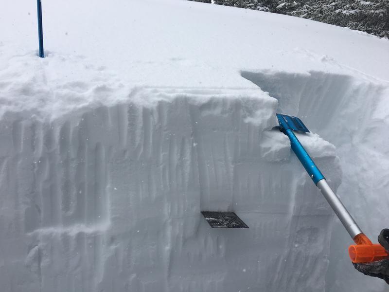
The crystal card is stuck into the layer that failed in our ECT. Most likely the interface between the New Year's storm and the 1/6-7 storm.
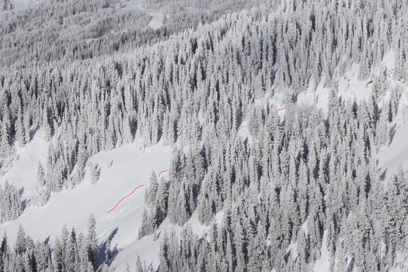
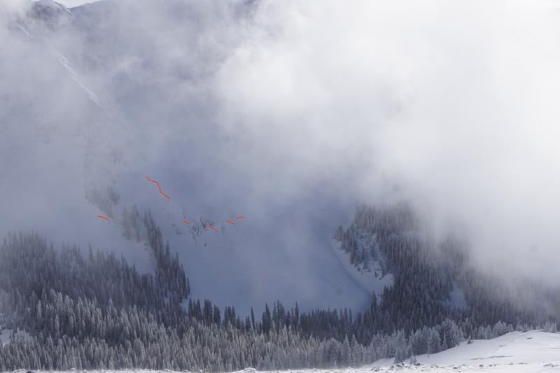
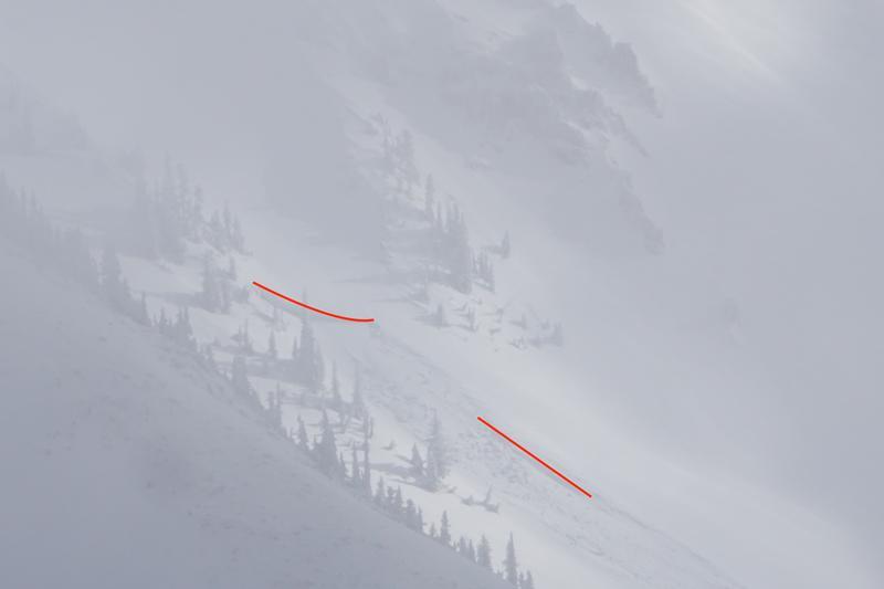
First Photo is of the Upper Pinto Glade Avalanche. You can just make out where the slide started in a very steep and rocky area. Second photo is Lone Pine area. Third is El Pinche. This slide was right in the gut of the run out of El Pinche. This slide looked pretty recent, and the crown looked pretty big. It's very possible it broke down to the Christmas interface. Hard to say for sure, visibility was limited as these slides were in and out of the clouds. Thanks Chris Benson for the photos, and for highlighting the slides.
Today's Observed Danger Rating
High
Tomorrows Estimated Danger Rating
Considerable