Join us at our 2nd Annual Blizzard Ball

Forecast for the Moab Area Mountains

Dave Garcia
Issued by Dave Garcia on
Tuesday morning, January 10, 2023
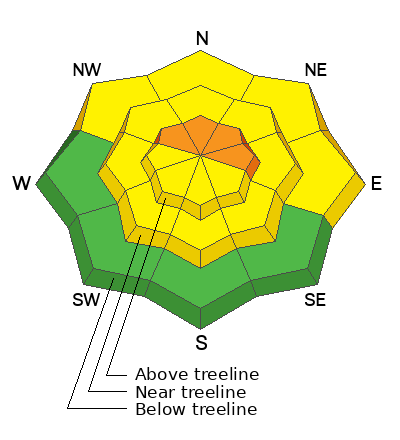
A CONSIDERABLE avalanche danger exists on steep, wind drifted slopes above treeline that face NW-N-NE-E. On these slopes, human triggered avalanches failing on a buried persistent weak layer are likely. Blowing and drifting snow has created a MODERATE danger for triggering an avalanche in wind drifted snow on all aspects near treeline and above. Backcountry travelers need to be on the lookout for fat, rounded pillows of wind drifted snow.
Low
Moderate
Considerable
High
Extreme
Learn how to read the forecast here
Special Announcements
Improve your avalanche awareness and rescue skills and sign up for our Backcountry 101 Class on January 20, 21.
Road Conditions: The road is plowed but areas of soft snow exist near the top. AWD and good tires recommended.
Grooming: Trails have been recently groomed. There will be a few inches of fresh snow on the trails today.
Weather and Snow
24 Hour Snow 4" 72 Hour Snow 5" Season Total Snow 135" Base Depth at Gold Basin 63"
Winds on Pre Laurel Peak SSE 29 G41 Temp 26F
Weather
Another storm has arrived in the La Sals. Strong Southerly winds will continue for the duration of the storm. Today winds will blow out of the SW at 20-30 mph with gusts around 45. We will see light snow showers today with 1-2" of accumulation. Snow will pick up again tonight with the possibility of an additional 4-6 inches. SW winds will be sustained in the 30's and gusting to 50 overnight. Windy conditions and light snow showers will linger through tomorrow. Skies clear Wednesday night and we will see sunny skies Thursday and Friday.

General Conditions
Skiing conditions remain great below treeline in sheltered areas. 5" of new snow will provide a nice refresh. Out of the wind zone, you will generally find a strong, deep snowpack. Windward slopes up high are becoming scoured after several days of strong Southerly winds. Windy conditions and five inches of new snow have created a mix of fresh sensitive slabs of wind drifted snow as well as older hard slabs that will be more stubborn. Backcountry travelers will need to avoid any slopes with fresh deposits of wind drifted snow.
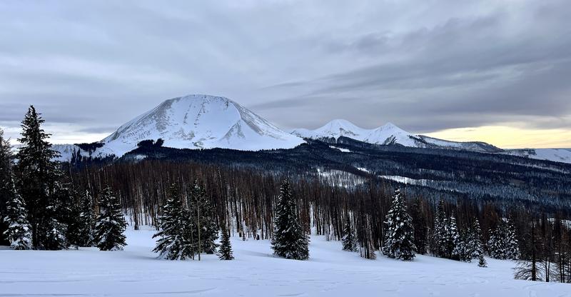
In this photo of the North Face of Mount Mellenthin you can see the effects of the wind above treeline.
As we trend towards Moderate danger, consider this: most avalanche fatalities occur when the danger is moving up from Moderate to Considerable, or back down from Considerable to Moderate.

Snowpack and Weather Data
Gold Basin Storm Stake (10,000')
Gold Basin SNOTEL site (10,000')
SNOTEL site near Geyser Pass Winter Trailhead (9600')
Wind Station on Pre-Laurel Peak (11,400')
NWS forecast for the La Sal Mountains.
Recent Avalanches
No new avalanches have been reported. Here is the La Sal Avalanche Database.
Ad
Avalanche Problem #1
Persistent Weak Layer
Type
Location
Likelihood
Size
Description
The widespread persistent weak layer (PWL) that formed in November is showing signs of strengthening and stability tests continue to be less reactive. In many places the snowpack is very deep and it is becoming difficult to even dig down to the weak layer. This means avalanches are becoming harder to trigger but the consequences remain very serious. Today, wind drifted snow will continue to put pressure on this weak layer. Any avalanche triggered on this deeply buried PWL can be 4-6 feet deep and unsurvivable. The greatest risk exists on steep, wind drifted, northerly aspects above treeline.
I have gained confidence in the snowpack to begin stepping out into moderate terrain in areas that I know have deep snow. I am looking to ski in simple terrain that has no terrain traps, cliff bands, or steep convexities. I know there are still some trigger points, or "not so sweet spots" out there. I am still avoiding big, radical terrain. Likely trigger points include thin snowpack areas along slope margins or near shallowly buried rock outcrops; and areas of steep, rocky terrain.
Avalanche Problem #2
Wind Drifted Snow
Type
Location
Likelihood
Size
Description
Strong southerly winds have been blowing for several days. In my travels yesterday, I observed a substantial amount of blowing and drifting snow. Winds were swirling in canyon bottoms and loading all aspects. This trend will continue with five inches of new snow to blow around today. Be on the lookout for fresh soft slabs of recent wind drifted snow near treeline today. Above treeline you will find a mix of new sensitive slabs and old, hard, more stubborn wind slabs. Slabs of wind drifted snow are dangerous on their own, but they will also add stress to the buried PWL. Any triggered wind slab has the potential to step down to the buried PWL, resulting in a deep and dangerous avalanche.
Recognizable by their fat, smooth, rounded appearance, stiff wind slabs may sound hollow underneath. Look for wind slabs on the leeward sides of ridge crests, and terrain features such as gully walls and sub ridges, and avoid slopes with recent deposits of wind drifted snow.
Additional Information
The Avalanche Beacon Training Park is up and running just above the Geyser Pass Traihead. It's right there and easy to use, so get some practice as you head up for your next tour.
General Announcements
This forecast is from the U.S.D.A. Forest Service, which is solely responsible for its content. This forecast describes general avalanche conditions and local variations always occur. This forecast will be updated by 7:30 tomorrow morning.