Join us at our 2nd Annual Blizzard Ball

Forecast for the Moab Area Mountains

Dave Garcia
Issued by Dave Garcia on
Wednesday morning, January 11, 2023
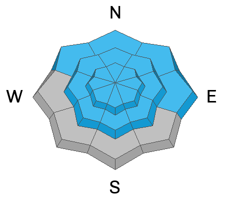
Your number one concern today is triggering avalanches in fresh slabs of wind drifted snow. You will find a CONSIDERABLE danger for this type of avalanche above treeline on slopes that face NW-N-NE-E. Human triggered avalanches are likely on these slopes. Above treeline on slopes that face W-SW-S-SE and on all aspects near treeline, the danger is MODERATE. On these slopes, it is possible for skiers and riders to trigger an avalanche in wind drifted snow. Backcountry travelers need to have a keen eye for recognizing and avoiding fat, rounded pillows of wind drifted snow.
While becoming less likely, it is still possible to trigger a deep, dangerous avalanche on a buried persistent weak layer of faceted snow. The danger for this type of avalanche is MODERATE on all slopes near treeline and above, and below treeline on slopes that face NW-N-NE-E
Low
Moderate
Considerable
High
Extreme
Learn how to read the forecast here
Special Announcements
Improve your avalanche awareness and rescue skills and sign up for our Backcountry 101 Class on January 20, 21.
Road Conditions: The road is plowed but areas of soft snow exist near the top. AWD and good tires recommended.
Grooming: Trails have been recently groomed. There will be a few inches of fresh snow on the trails today.
Weather and Snow
24 Hour Snow 3" 72 Hour Snow 8" Season Total Snow 138" Base Depth at Gold Basin 60"
Winds on Pre Laurel Peak WSW 16 G24 Temp 16F
Weather
The quick moving Pacific low has dropped 3 inches of snow since midnight. Snowfall will continue this morning and should taper off around noon. We might squeeze another couple of inches out of this storm before it's over. Southerly winds have been howling throughout the storm. Overnight, gusts were in the 30's and 40's. Winds will shift to the WNW today and blow 20-25 mph with gusts around 40. Skies will clear tonight, and Thursday and Friday will be sunny and cold. Another disturbance moves in Saturday and the pattern stays active into next week.

General Conditions
Yesterday's five inches of new snow came in dense and wind driven, the kind of snow that keeps you on top. While we have received another three inches of snow, the real story is the wind. Strong, sustained southerly winds over the past several days continue to scour and load slopes near treeline and above. Fresh slabs of wind drifted snow will be your primary concern today. Be on the lookout for fat, rounded pillows of wind drifted snow on all aspects. These fresh slabs will be most pronounced on leeward slopes on the North half of the compass. While it is still possible to trigger an avalanche on our deeply buried persistent weak layer, the likelihood is becoming less. This problem is predominantly found on steep, rocky, Northerly facing terrain.
Check out this video from yesterday of blowing and drifting snow into the NE facing slopes of Upper Horsecreek.

Snowpack and Weather Data
Gold Basin Storm Stake (10,000')
Gold Basin SNOTEL site (10,000')
SNOTEL site near Geyser Pass Winter Trailhead (9600')
Wind Station on Pre-Laurel Peak (11,400')
NWS forecast for the La Sal Mountains.
Recent Avalanches
No new avalanches have been reported. Here is the La Sal Avalanche Database.
Ad
Avalanche Problem #1
Wind Drifted Snow
Type
Location
Likelihood
Size
Description
Your biggest concern today will be triggering an avalanche in wind drifted snow. Fresh wind slabs will be primarily found on leeward slopes that face Northwest to North to East above treeline. In my travels yesterday I observed swirling winds changing direction and loading a variety of aspects near treeline and above. Don't neglect mid elevation terrain down off the ridgelines, where you will find cross-loaded gullies and sub-ridges. Shooting cracks under your feet are a sure sign you have found a fresh wind drift. Fresh drifts will look smooth, round, and fat.
Strong south winds have been sustained for several days and old, hard wind drifts exist above treeline. These older drifts are stubborn and harder to trigger, creating a dangerous situation by allowing you to get further out on the slab before it fails. Hard drifts often produce hollow, drum like sounds when you walk on them.
Backcountry travelers need to avoid any slope with recently wind drifted snow. Any avalanche triggered in wind drifted snow has the potential to step down to the buried persistent weak layer causing a deeper and more dangerous avalanche.
Avalanche Problem #2
Persistent Weak Layer
Type
Location
Likelihood
Size
Description
While it is becoming less likely to trigger an avalanche on the buried persistent weak layer, it is still possible and the consequences remain very dangerous. Any avalanche triggered on the deeply buried weak layer would be large and unsurvivable. These avalanches can be four to six feet deep. The greatest danger for this type of avalanche exists on steep, wind drifted terrain above treeline that faces NW-N-NE-E.
I have gained confidence in the snowpack to begin stepping out into moderate terrain in areas that I know have deep snow. I am looking to ski in simple terrain that has no terrain traps, cliff bands, or steep convexities. I know there are still some trigger points, or "not so sweet spots" out there. I am still avoiding big, radical terrain. Likely trigger points include thin snowpack areas along slope margins or near shallowly buried rock outcrops; and areas of steep, rocky terrain. For more information on this check out my fieldwork from yesterday.
Additional Information
The Avalanche Beacon Training Park is up and running just above the Geyser Pass Traihead. It's right there and easy to use, so get some practice as you head up for your next tour.
General Announcements
This forecast is from the U.S.D.A. Forest Service, which is solely responsible for its content. This forecast describes general avalanche conditions and local variations always occur. This forecast will be updated by 7:30 tomorrow morning.