Donate to the 2024 Spring Campaign to help rebuild the UAC website.

Forecast for the Logan Area Mountains

Toby Weed
Issued by Toby Weed for
Saturday, April 20, 2019
Rapid warming, mountaintop temperatures rising well above 50ºF, and intense solar warning will again create dangerous avalanche conditions and CONSIDERABLE danger, especially on sunny slopes. Natural and human triggered wet avalanches and large cornice falls are likely on steep slopes during the heat of the day.
  • Head home early, and use extra caution. Evaluate snow and terrain carefully.
Low
Moderate
Considerable
High
Extreme
Learn how to read the forecast here
Special Announcements
Thank you to everyone who supported our spring fundraiser. We reached our goals. The Utah Avalanche Center could not exist without your support.
Weather and Snow
The Tony Grove Snotel at 8400' reports 83 inches of total snow, and it's 46ºF this morning. Its 42ºF at the 9700' CSI Logan Peak weather station, and south winds are currently averaging around 25 mph.
Rapid warming and mountaintop temperatures well above 50ºF will again create dangerous wet avalanche conditions on steep sunny slopes in the Logan Zone.
A mild southwesterly flow will keep above average temperatures in place through today. A mild storm system will cross the state late tonight through Monday, followed by high pressure for the middle of next week.
It will be partly sunny today in the mountains again, with high temperatures at 9000' expected to be around 54ºF and 8 to 14 mph south-southwest wind. Scattered rain and snow showers are possible this afternoon, and some thunder is also possible. Rain and snow showers are likely tonight, and thunder is possible. It will be mostly cloudy with low temperatures around 34ºF, and 11 to 16 mph southwest winds. Rain and snow showers will change over to all snow tomorrow afternoon, with a chance of thunder but little accumulation expected. Expect high temperatures around 43ºF and 5 to 15 mph north-northwest wind, veering from the west in the afternoon.

Here is a short video from Utah Avalanche Center Staff about Spring snow.

Recent Avalanches
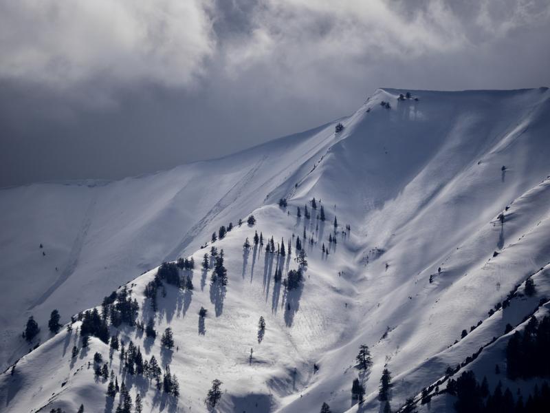
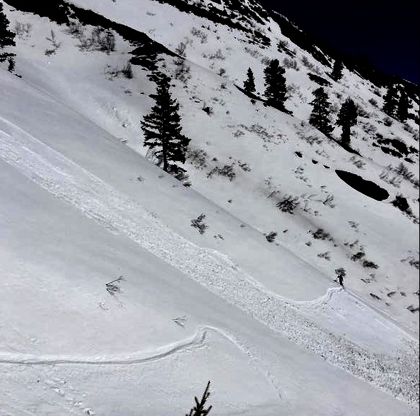
We can see numerous recent natural wet loose avalanches from Cache Valley today after the rainy and increasingly warm weather this week. Widespread natural loose avalanches entraining wet new snow were observed across the Logan Zone on many steep slopes at upper and mid elevations, and some were pretty long running. Skiers report triggering sizable wet loose avalanches on the north side of Logan Peak on Thursday and in Bird Canyon in the Wellsville Mountain Wilderness yesterday.
A skier triggered wet loose avalanche in Bird Canyon occurred at around 10:30 yesterday morning.
Natural wet avalanches from cornice falls occurred during the heat of the day yesterday in the backcountry cirques above Snowbasin.
The heat is causing large ridge top cornices to buckle and sag, and large pieces to calve off creating wet avalanches on slopes below.
Numerous fairly large natural wet loose and a few wet slab avalanches occurred in the first half of April across the Logan Zone.
Ad
Avalanche Problem #1
Wet Snow
Type
Location
Likelihood
Size
Description
The surface of the snow is only superficially refrozen after a warm night. Temperatures are around 10 degrees F warmer this morning then they were yesterday at this time, with all stations in the Logan Zone reading well above above freezing again overnight. Rapid seasonal daytime warming and strong April sun will cause increasing danger of wet avalanches entraining saturated snow. Dangerous natural and human triggered wet slab avalanches will become possible in steep sunny terrain, and wet loose avalanches are likely in the afternoon.
  • Avoid being on or under steep slopes with melt-softened saturated snow, and stay out of runout gullies.
Avalanche Problem #2
Cornice
Type
Location
Likelihood
Size
Description
Stay off and out from under large ridge top cornices, which are likely to break further back than expected, and could trigger avalanches on steep slopes below.
Additional Information
We will continue to post intermittent and weekend updates through April.
Spring snow in the Logan Zone...
General Announcements
Check out the improved weather links, road conditions, and weather links for each forecast region on the new UAC IOS App. Do you use the NOAA point forecast? If so, now you can bookmark your favorite weather locations in "My Weather" in the App. HERE
Are you new to the backcountry or looking to refresh your skills? The UAC has released a free 5-part avalanche skills eLearning series. HERE
If you would like to get the daily advisory by email you subscribe HERE.
Support the UAC through your daily shopping. When you shop at Smith's, or online at REI, Backcountry.com, Patagonia, NRS, Amazon, eBay by clicking on these links, they donate a portion of your purchase to the UAC. If you sell on eBay, you can have your See our Affiliate Page for more details on how you can support the UAC when you shop
Remember your information can save lives. If you see anything we should know about, please help us out by submitting snow and avalanche observations. HERE You can call us at 801-524-5304, email by clicking HERE, or include #utavy in your Instagram.
This forecast is from the U.S.D.A. Forest Service, which is solely responsible for its content. The forecast describes general avalanche conditions and local variations always occur.