Forecast for the Logan Area Mountains

Toby Weed
Issued by Toby Weed for
Saturday, March 9, 2019
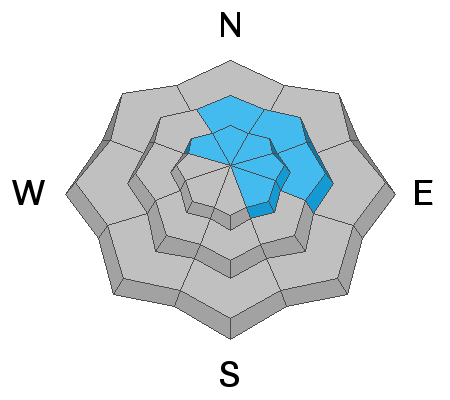
MODERATE: Heightened avalanche conditions exist at mid and upper elevations in the Logan Zone. Human triggered soft slab or wind slab avalanches 1 to 3 feet deep are possible today. In some areas avalanches could fail on a persistent weak layer of surface hoar or sugary faceted snow buried by this week's storm.
  • Evaluate snow and terrain carefully, and make conservative decisions.
  • Avoid ridge top cornices and steep slopes with recently wind drifted snow.
Low
Moderate
Considerable
High
Extreme
Learn how to read the forecast here
Special Announcements
Enjoy spring skiing at Snowbasin Resort. The UAC has discount Snowbasin tickets available. HERE
Weather and Snow
The Tony Grove Snotel at 8400' reports about 6" of new snow with .4" SWE in the past 24 hrs and about 2 feet with 2.9" SWE since Wednesday morning. It's 14 ºF this morning and there is 101" of total snow with 110% of normal SWE. It's 7 ºF at the 9700' CSI Logan Peak weather station, and west-southwest winds are currently averaging around 20 mph. Use caution today at upper and mid elevations with all the new snow. Heightened avalanche conditions exist and you could trigger 1 to 3 foot deep avalanches on some upper and mid elevation slopes.

A weak boundary will bring scattered snow showers to central and northern Utah today into Sunday. The next storm system will track east across the Desert Southwest early next week, bringing precipitation to mainly the southern and western portions of the state. It'll be mostly cloudy today, with a chance of snow showers. High temperatures at 8500' expected be around 21ºF, with 10 to 15 mph west-southwest winds. Snow showers are possible tonight, with little accumulation, low temperatures expected to be around 10º F, with increasing, 10 mph west-southwest winds, veering from the east-southeast after miodnight. Looks like snow showers and mostly cloudy skies, with little accumulation again tomorrow. High temperatures will be around 27 ºF, with 10 to 15 mph east winds.

Here's what 100 inches of snow looks like stacked up on the bathrooms at Tony Grove Campground!
Recent Avalanches
There were many small and some medium sized natural avalanches with this week's warm and very productive storm. Thursday, we could see evidence of dozens of small and medium sized natural soft storm slab, loose sluffs, and wind slab avalanches of new snow in the Tony Grove Area. More fresh natural avalanches were observed in the Tony Grove Area yesterday, and snowcat ski guides intentionally triggered numerous soft slab avalanches up to around 2 feet deep yesterday in the Southern Bear River Range.

The sun came out Thursday afternoon and several good sized natural wet avalanches hit the Logan River below Temple Fork.
​​​​​​​
Ad
Avalanche Problem #1
Wind Drifted Snow
Type
Location
Likelihood
Size
Description
Drifting from moderate westerly winds created heightened conditions on exposed upper and mid elevation slopes. Avalanches of fresh wind drifted snow, 1 to 3 feet deep, are possible. Avalanches could run far and fast down well filled in avalanche paths, possibly on Wednesday's rain crust.
  • Stay clear of large ridge top cornices, which are likely to break further back than you expect and could trigger avalanches on steep slopes below.
  • Avoid freshly formed drifts on the lee side of major ridges and in and around terrain features like sub-ridges, scoops, stringers, gullies, and cliff bands.

Avalanche Problem #2
New Snow
Type
Location
Likelihood
Size
Description
Soft slab and loose avalanches involving new snow are possible even in sheltered terrain today. New snow instabilities usually heal quickly, but there were numerous natural and triggered soft slab and loose avalanches in the area in the past couple days. Recent natural avalanches appeared to be failing on a density change or graupel layer within the new snow, but avalanches in some areas could step down to a recently buried persistent weak layer. In many areas earlier in the week we observed surface hoar feathers and in others, a shallow layer of weak sugary snow on top of a hard melt-freeze crust.
Additional Information
I will update this forecast Monday morning.
The new weather station at the WSU Bloomington Canyon Yurt is up and running. Data available HERE
Now is a great time to practice companion rescue techniques with your backcountry partners. You should check out and use the new Avalanche Beacon Training Park we set up at the Franklin Basin trailhead. Special thanks to Northstars Ultimate Outdoors, USU Outdoor Program, and Beaver Mountain Ski Patrol for helping us to make this possible.
General Announcements
The Beaver Mountain Backside is the backcountry, and it is avalanche terrain. Same goes for the steep rocky terrain adjacent to Cherry Peak Resort. If you leave a ski area boundary, you and your partners should carry and practice with avalanche rescue equipment and follow safe backcountry travel protocols.
Check out the improved weather links, road conditions, and weather links for each forecast region on the new UAC IOS App. Do you use the NOAA point forecast? If so, now you can bookmark your favorite weather locations in "My Weather" in the App. HERE
Are you new to the backcountry or looking to refresh your skills? The UAC has released a free 5-part avalanche skills eLearning series. HERE
If you would like to get the daily advisory by email you subscribe HERE.
Support the UAC through your daily shopping. When you shop at Smith's, or online at REI, Backcountry.com, Patagonia, NRS, Amazon, eBay by clicking on these links, they donate a portion of your purchase to the UAC. If you sell on eBay, you can have your See our Affiliate Page for more details on how you can support the UAC when you shop
Remember your information can save lives. If you see anything we should know about, please help us out by submitting snow and avalanche observations. HERE You can call us at 801-524-5304, email by clicking HERE, or include #utavy in your Instagram.
This forecast is from the U.S.D.A. Forest Service, which is solely responsible for its content. The forecast describes general avalanche conditions and local variations always occur.