Donate to the 2024 Spring Campaign to help rebuild the UAC website.

Forecast for the Logan Area Mountains

Toby Weed
Issued by Toby Weed for
Friday, March 8, 2019
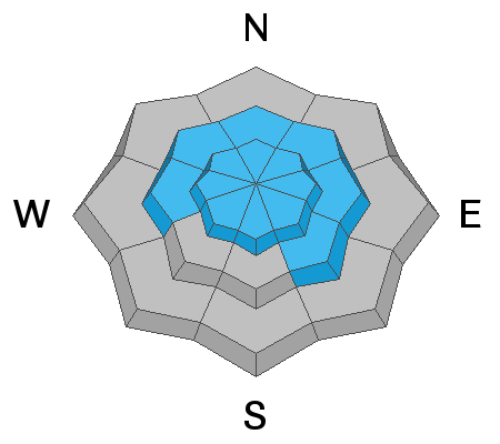
CONSIDERABLE: Dangerous avalanche conditions exist at mid and upper elevations in the Logan Zone. Human triggered avalanches up to about two feet deep involving heavy new snow or wind drifted snow are likely today. Natural activity is possible, especially during periods of heavy snowfall. Avalanches could fail on a persistent weak layer of surface hoar or sugary faceted snow buried by yesterday's storm.
  • Use extra caution, evaluate snow and terrain carefully, and make conservative decisions. Avoid ridge top cornices and steep slopes with wind drifted snow.
Low
Moderate
Considerable
High
Extreme
Learn how to read the forecast here
Special Announcements
Enjoy spring skiing at Snowbasin Resort. The UAC has discount Snowbasin tickets available. HERE
Weather and Snow
The Tony Grove Snotel at 8400' stopped reporting yesterday afternoon, but already 16 inches of heavy new snow had accumulated and the station had topped 100 inches on the total snow stake for the first time this year. About two feet of fairly heavy snow fell at upper elevations with about 2.5" SWE so far with this storm. It's 25ºF this morning at the UDOT Hwy 89 Logan Summit Station, with 10 to 15 mph east-southeast winds. It's 19 ºF at the 9700' CSI Logan Peak weather station, and shifty northeast winds are currently averaging around 20 mph.
Here's what 100 inches of snow looks like stacked up on the bathrooms at Tony Grove Campground!

The upper level trough currently over Nevada will continue east across Utah today. Trailing this feature will be a secondary shortwave this evening, followed by building heights across the eastern Great Basin ahead of a new storm system moving south along the west coast this weekend. Expect nicer, light powder snow in the mountains today, with 4 to 8 inches of accumulation possible. Temperatures at 8500' expected be around 26ºF, with 5 to 15 mph easterly winds, veering from the west in the afternoon. Snow showers will continue tonight,with 1 to 3 inches possible, low temperatures expected to be around 7º F, with increasing, 20 mph west winds. Looks like snow showers and mostly cloudy skies, with little accumulation tomorrow. Tomorrow temperatures will be around 20 ºF, wind chills around -9 ºF, with 15 mph west winds.
Recent Avalanches
There were many small and some medium sized natural avalanches with yesterday's warm and very productive storm.
  • The sun came out yesterday afternoon and several good sized natural wet avalanches hit the Logan River below Temple Fork.
  • Yesterday, we could see evidence of dozens of small and medium sized natural soft storm slab, loose sluffs, and wind slab avalanches of new snow in the Tony Grove Area.
Ad
Avalanche Problem #1
New Snow
Type
Location
Likelihood
Size
Description
Soft slab and loose avalanches involving new snow will become increasingly likely even in sheltered terrain today as more new snow stacks up on mountain slopes. Yesterday's natural avalanches in the Tony Grove Area appeared to be failing on a density change or graupel layer within the new snow, but avalanches could step down to a recently buried persistent weak layer. In many areas earlier in the week we observed surface hoar feathers and in others, a shallow layer of weak sugary snow on top of a hard melt-freeze crust.
Avalanche Problem #2
Wind Drifted Snow
Type
Location
Likelihood
Size
Description
Avalanches of fresh wind drifted snow are likely on upper elevation slopes. Drifting from moderate westerly winds created dangerous conditions in some areas yesterday, and winds veered from the east-northeast overnight. The winds are fairly light this morning, but will switch from the west and increase a bit this afternoon, and with today's light snow significant drifting is likely to occur.
  • Stay clear of large ridge top cornices, which are likely to break further back than you expect and could trigger avalanches on steep slopes below.
  • Avoid freshly formed drifts on the lee side of major ridges and in and around terrain features like sub-ridges, scoops, stringers, gullies, and cliff bands.
Avalanche Problem #3
Wet Snow
Type
Location
Likelihood
Size
Description
Heavy rain Wednesday night saturated and softened the snow, and there were several natural wet avalanches yesterday that hit the Logan River below Temple Fork. Cooling temperatures will help today, but wet avalanches will remain possible on steep low elevation slopes until the saturated snow refreezes. You should continue to avoid and stay out from under steep slopes with soft, saturated snow.
Additional Information
I will update this forecast tomorrow morning.
The new weather station at the WSU Bloomington Canyon Yurt is up and running. Data available HERE
Now is a great time to practice companion rescue techniques with your backcountry partners. You should check out and use the new Avalanche Beacon Training Park we set up at the Franklin Basin trailhead. Special thanks to Northstars Ultimate Outdoors, USU Outdoor Program, and Beaver Mountain Ski Patrol for helping us to make this possible.
General Announcements
The Beaver Mountain Backside is the backcountry, and it is avalanche terrain. Same goes for the steep rocky terrain adjacent to Cherry Peak Resort. If you leave a ski area boundary, you and your partners should carry and practice with avalanche rescue equipment and follow safe backcountry travel protocols.
Check out the improved weather links, road conditions, and weather links for each forecast region on the new UAC IOS App. Do you use the NOAA point forecast? If so, now you can bookmark your favorite weather locations in "My Weather" in the App. HERE
Are you new to the backcountry or looking to refresh your skills? The UAC has released a free 5-part avalanche skills eLearning series. HERE
If you would like to get the daily advisory by email you subscribe HERE.
Support the UAC through your daily shopping. When you shop at Smith's, or online at REI, Backcountry.com, Patagonia, NRS, Amazon, eBay by clicking on these links, they donate a portion of your purchase to the UAC. If you sell on eBay, you can have your See our Affiliate Page for more details on how you can support the UAC when you shop
Remember your information can save lives. If you see anything we should know about, please help us out by submitting snow and avalanche observations. HERE You can call us at 801-524-5304, email by clicking HERE, or include #utavy in your Instagram.
This forecast is from the U.S.D.A. Forest Service, which is solely responsible for its content. The forecast describes general avalanche conditions and local variations always occur.