Forecast for the Logan Area Mountains

Toby Weed
Issued by Toby Weed on
Friday morning, March 9, 2018

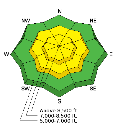
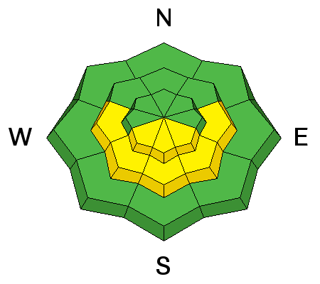
The snow is stable and the danger LOW on many slopes in the Logan Zone, but heightened conditions still exist and there's a MODERATE avalanche danger in the backcountry. Evaluate snow and terrain carefully.

  • You could trigger cornice falls or wind slab avalanches in drifted terrain at upper elevations.
  • Dangerous persistent slab avalanches remain possible on isolated slopes with poor snow structure.
  • Solar warming or green-housing could soften crusts and create a danger of loose wet avalanches on slopes with saturated surface snow.

Low
Moderate
Considerable
High
Extreme
Learn how to read the forecast here
Special Announcements

Episode 6 of the UAC podcast "A Conversation with Tom Kimbrough, Hemingway of the Wasatch" is live. We explore ideas about lifetime exposure to risk and what role Buddhism has played in his life as a climber, skier, and soon-to-be octogenarian. We talk about what has changed over the years in snow science and the role of mentorship in the world of avalanche forecasting and other professions and pursuits. Check it out on ITunes, Stitcher, the UAC blog.

Weather and Snow

There are still isolated areas with poor snow structure and some potential for avalanches failing on buried persistent weak layers in the Logan Zone, but we've found good stability on most slopes. There were a few good sized natural avalanches in the Wellsville Mountain and Mount Naomi Wilderness Areas during last weekend's windy storm, but the evidence is mostly blown in and obscured. Loose wet and dry sluffs, minor wind slabs, and cornice falls were reported and observed this week. You'll still find pretty good powder conditions in north facing terrain, but strong March sun moistened the snow on sunny slopes and at lower elevations, so there is a widespread variable melt-freeze crust.

  • The Tony Grove Snotel at 8400' reports 31°F, and 72 inches of total snow, with 86% of normal SWE.
  • It's 33°F at the UDOT Hwy 89 Logan Summit this morning, and a west wind is blowing 15 mph, and gusting to about 25 mph.


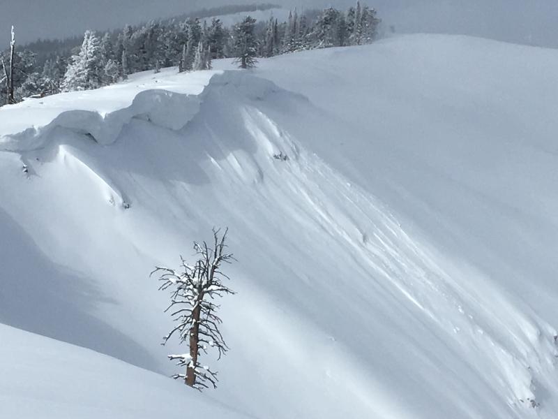
Drifting over the weekend built out large cornices on the major ridges. You should avoid these as they can break further back than expected.

Recent Avalanches

Yesterday, a skier triggered and was caught, carried, and injurred in large persistent slab avalanche in Big Cottonwood Canyon in the Wasatch Range. The report is HERE

It has been an active week in the mountains of Utah and numerous other natural and human triggered avalanches from the last few days are posted on our avalanche list HERE.


We observed only isolated natural avalanches after last weekend's storm. This week, triggered and natural cornice falls, shallow soft slabs, and loose wet avalanches have occurred in the Logan Zone, but there are no reports of incidents or close calls.

Ad
Avalanche Problem #1
Wind Drifted Snow
Type
Location
Likelihood
Size
Description

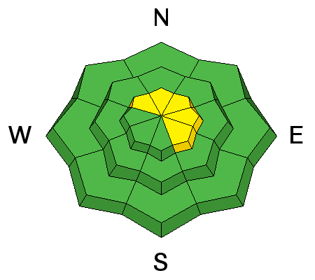
Human triggered avalanches and cornice falls are possible in drifted upper elevation terrain.

  • Watch for and avoid drifted snow in and around terrain features like cliff bands, gullies, scoops, and sub-ridges.
  • Wind slabs will be found on the lee side of major ridges, on slopes below cornices, in saddles, and downwind of open fetch areas.
  • Avoid ridge-top cornices, which often break further back than expected and can trigger avalanches on drifted slopes below.
  • Some wind slab avalanches could step down to buried weak faceted layers.

Avalanche Problem #2
Persistent Weak Layer
Type
Location
Likelihood
Size
Description

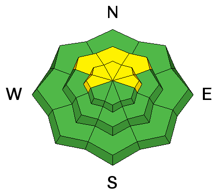
Heightened persistent slab avalanche conditions exist, especially on slopes with shallow overall snow cover. If you sink deeply into loose sugary snow or easily hit the ground when you stick your ski pole through shallow loose snow, you've found poor snow structure, but in many areas you have to dig a snowpit to find the weak sugary layers.

  • Avoid steep rocky slopes with shallow snow cover and poor snow structure.
  • Persistent slab avalanches might be remote triggered, from a distance or below.
  • Cracking and collapsing or whumpfing are red flags indicating unstable snow.
Avalanche Problem #3
Wet Snow
Type
Location
Likelihood
Size
Description

Solar warming or green-housing will probably soften the crust from yesterday in some areas and cause increasing danger of loose wet avalanches, entraining the weekend's snow. Wet sluffs can get pretty big and unmanageable on sustained steep slopes.

  • Roller balls, pinwheels, and natural sluffs indicate possible loose wet activity
  • It's time to move off slopes if you are sinking into slushy or sticky snow


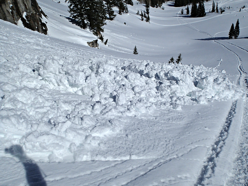
This wet sluff in the Central Bear River Range occurred midday Wednesday, triggered by saturated snow rolling off rocks above.

Additional Information

The broad area of high pressure aloft across the western states will generate a warming trend across Utah through the end of the week.

  • Today: Isolated snow showers. Mostly cloudy, with a high near 33. West southwest wind 13 to 17 mph. Chance of precipitation is 20%.
  • Tonight: A 50 percent chance of snow showers. Mostly cloudy, with a low around 20. West wind 14 to 17 mph. New snow accumulation of less than a half inch possible.
  • Saturday: Mostly sunny, with a high near 32. Northwest wind 5 to 15 mph.
General Announcements

We have discount lift tickets for Alta, Snowbird, Brighton, Solitude, Snowbasin,and Beaver Mountain. Details and order information here. All proceeds from your purchase go towards paying for avalanche forecasting and education.

Episode 5 of the UAC podcast To Hell in a Heartbeat - A Conversation With Tom Diegel and Matt Clevenger About the 12.26.08 Full Burial on Little Water is live. This podcast talks with Matt and Tom about their experience and the massive success of the To Hell in a Heartbeat video which has been viewed almost 3M times. Check it out on ITunes, Stitcher, the UAC blog, or wherever you get your podcasts.

The UAC Marketplace is online. The holiday auction is closed, but our online marketplace still has deals on skis, packs, airbag packs, beacons, snowshoes, soft goods and much more.

The UAC has new support programs with Outdoor Research and Darn Tough. Support the UAC through your daily shopping. When you shop at Smith's, or online at Outdoor Research, REI, Backcountry.com, Darn Tough, Patagonia, NRS, Amazon, eBay a portion of your purchase will be donated to the FUAC. See our Donate Page for more details on how you can support the UAC when you shop.

Benefit the Utah Avalanche Center when you buy or sell on eBay - set the Utah Avalanche Center as a favorite non-profit in your eBay account here and click on eBay gives when you buy or sell. You can choose to have your seller fees donated to the UAC, which doesn't cost you a penny Check it out on ITunes, Stitcher, the UAC blog, or wherever you get your podcasts.

Now is a great time to practice companion rescue techniques with your backcountry partners. Here's our rescue practice video.

EMAIL ADVISORY: If you would like to get the daily advisory by email you will need to subscribe here.

Remember your information can save lives. If you see anything we should know about, please help us out by submitting snow and avalanche observations. You can also call us at 801-524-5304, email by clicking HERE, or include #utavy in your Instagram.

This advisory is from the U.S.D.A. Forest Service, which is solely responsible for its content. This advisory describes general avalanche conditions and local variations always occur.