Enjoy spring skiing at Snowbasin Resort. The UAC has discount Snowbasin tickets available.
HERE
A few inches of heavy snow and drifting from strong south-southwest winds overnight created heightened avalanche conditions at upper elevations, and you could trigger avalanches consisting of fresh wind drifted snow this morning. Loose wet avalanches are possible on rain-saturated slopes at lower elevations, below the rain/snow line at around 7500'. As more heavy snow accumulates, soft slab and loose storm snow avalanches failing on preexisting weak surface snow will become increasingly likely, even in sheltered terrain.
We found glittering surface hoar on the ridges and in avalanche starting zones Monday. In some areas it may have survived last night's wind and rain.
The Tony Grove Snotel at 8400' reports about 4 inches of heavy new snow, with .5" SWE from overnight. It's 32ºF this morning and there's 87"of total snow containing 104% of average SWE for the date. It's 27 ºF at the 9700' CSI Logan Peak weather station, and southwest winds are currently averaging around 30 mph, with a 56 mph gust earlier this morning.
The very moist air mass over Utah combined with a series of passing weather disturbances will bring widespread, and at times heavy precipitation through the end of the week. Expect moist snow in the mountains today, with 3 to 5 inches of accumulation possible. Temperatures at 8500' expected to drop to around 27ºF, this morning, with 15 to 20 mph south-southwest winds. It'll snow tonight, with 3 to 7 inches possible, low temperatures expected to rise to around 31º F, with 20 mph west winds. Snow will continue tomorrow, with 3 to 5 inches possible, a high temperature around 32 ºF and 20 mph southwest winds.
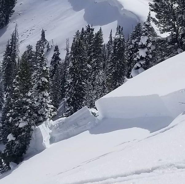
A rider triggered a large hard slab avalanche yesterday in Caribou Basin in the Wasatch Range above Midway. No new avalanches were reported in the Logan Zone since last week's wind-spawned natural activity.