Donate to the 2024 Spring Campaign to help rebuild the UAC website.

Forecast for the Logan Area Mountains

Toby Weed
Issued by Toby Weed for
Monday, March 4, 2019
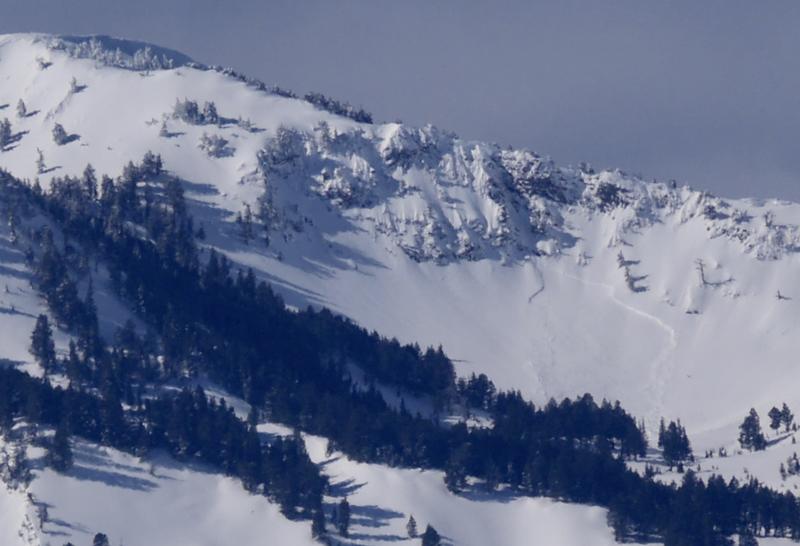
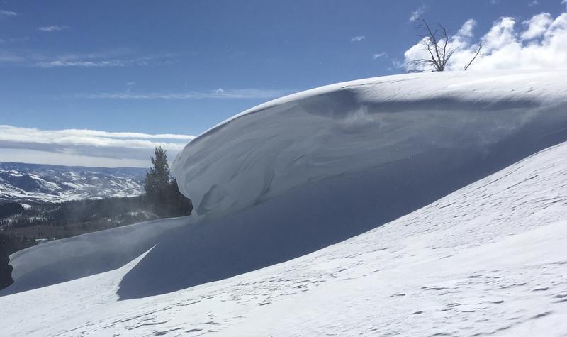
LOW: You can find excellent riding conditions in the Logan Zone. Snow is stable on most slopes, and avalanches are generally unlikely. Continue to avoid large cornices and previously wind drifted snow on steep upper elevation slopes.
  • Use normal caution.
Low
Moderate
Considerable
High
Extreme
Learn how to read the forecast here
Special Announcements
Enjoy spring skiing at Snowbasin Resort. The UAC has discount Snowbasin tickets available. HERE
Weather and Snow
You can still find very nice spring powder riding conditions in the backcountry. The snow is stable on most slopes, and avalanches are generally unlikely, but they remain possible and you should still use caution, especially in drifted upper elevation terrain. Continue to avoid large overhanging cornices and steep slopes with previously wind drifted snow.

The Tony Grove Snotel at 8400' reports 11ºF and there's 87" of total snow containing 102% of average SWE for the date. It's 7 ºF at the 9700' CSI Logan Peak weather station, and southwest winds are currently averaging around 20 mph.
High pressure will expand east across the Great Basin tonight through Tuesday. A series of mild but very moist storms will impact Utah during the middle and latter portions of this week. It'll be sunny in the mountains today. High temperatures at 8500' expected to be around 21ºF, with 5 to 10 mph west winds. It'll be mostly cloudy tonight, low temperatures expected to be around 10º F, with 6 to 11 mph southwest winds. It should be mostly cloudy tomorrow, with a high temperature around 29 ºF and 10 to 15 mph south winds.
Recent Avalanches
A handful of skier triggered but apparently manageable avalanches involving wind drifted and loose new snow were reported from the Wasatch Range yesterday.
Evidence of natural avalanche activity was apparent in the Logan Zone with clearing Friday, and we could see where cornices broke off and triggered wind slab avalanches below. Some deeper hard slab avalanches also occurred, like this one off Box Elder Peak in the Wellsville Mountain Wilderness.
Ad
Avalanche Problem #1
Normal Caution
Type
Location
Likelihood
Size
Description
The snow is stable on most slopes and the danger is Low, but that doesn't mean no danger. It is very important that you continue to use safe travel techniques, by only exposing one member of your group at a time to avalanche risk, while the rest of the party watches closely from a safer area. You may want to change your batteries, and we recommend you do a mid-season check of all your critical rescue gear.
  • Loose dry and wet avalanches or sluffs are possible in steep terrain, so watch for possible terrain traps or trees below.
  • Avalanches of wind drifted snow are possible on isolated very steep, previously drifted slopes. Hard, older wind slabs are devious, and sometimes let people get out on them before releasing.
  • Dangerous deep hard slab avalanches failing on a persistent weak layer are very unlikely, yet there's still a slight chance in outlying very steep rocky terrain with poor snow structure.
Avalanche Problem #2
Cornice
Type
Location
Likelihood
Size
Description
You should continue to stay clear of ridge top cornices, which have grown quite large in places. Cornices are likely to break much further back than expected and may trigger avalanches on steep slopes below.
Additional Information
I will update this forecast Wednesday morning.
The new weather station at the WSU Bloomington Canyon Yurt is up and running. Data available HERE
Now is a great time to practice companion rescue techniques with your backcountry partners. You should check out and use the new Avalanche Beacon Training Park we set up at the Franklin Basin trailhead. Special thanks to Northstars Ultimate Outdoors, USU Outdoor Program, and Beaver Mountain Ski Patrol for helping us to make this possible.
General Announcements
The Beaver Mountain Backside is the backcountry, and it is avalanche terrain. Same goes for the steep rocky terrain adjacent to Cherry Peak Resort. If you leave a ski area boundary, you and your partners should carry and practice with avalanche rescue equipment and follow safe backcountry travel protocols.
Check out the improved weather links, road conditions, and weather links for each forecast region on the new UAC IOS App. Do you use the NOAA point forecast? If so, now you can bookmark your favorite weather locations in "My Weather" in the App. HERE
Are you new to the backcountry or looking to refresh your skills? The UAC has released a free 5-part avalanche skills eLearning series. HERE
If you would like to get the daily advisory by email you subscribe HERE.
Support the UAC through your daily shopping. When you shop at Smith's, or online at REI, Backcountry.com, Patagonia, NRS, Amazon, eBay by clicking on these links, they donate a portion of your purchase to the UAC. If you sell on eBay, you can have your See our Affiliate Page for more details on how you can support the UAC when you shop
Remember your information can save lives. If you see anything we should know about, please help us out by submitting snow and avalanche observations. HERE You can call us at 801-524-5304, email by clicking HERE, or include #utavy in your Instagram.
This forecast is from the U.S.D.A. Forest Service, which is solely responsible for its content. The forecast describes general avalanche conditions and local variations always occur.