Donate to the 2024 Spring Campaign to help rebuild the UAC website.

Forecast for the Logan Area Mountains

Toby Weed
Issued by Toby Weed for
Saturday, March 2, 2019
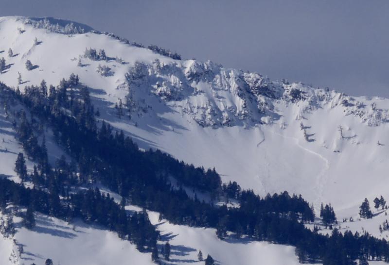
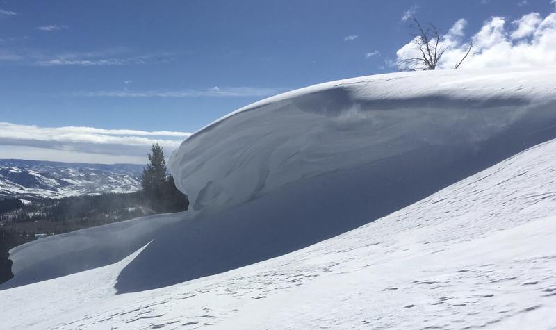
MODERATE: Heightened avalanche conditions exist on drifted slopes at upper elevations and on some at mid elevations facing north, northeast, east, and southeast. Triggered avalanches of wind drifted snow, 1 to 3 feet deep, and large cornice falls are possible. You can find very nice spring powder riding conditions, mostly stable snow, and LOW danger in sheltered terrain and on lower angled slopes.
  • Evaluate snow and terrain carefully.
  • Avoid large ridge top cornices and steep slopes with wind drifted snow.
Low
Moderate
Considerable
High
Extreme
Learn how to read the forecast here
Special Announcements
Enjoy spring skiing at Snowbasin Resort. The UAC has discount Snowbasin tickets available. HERE
Weather and Snow
You can find very nice spring powder riding conditions in the backcountry this weekend. Avoid large overhanging cornices and steep slopes with recently wind drifted snow, and you will find mostly stable snow and generally low danger.

The Tony Grove Snotel at 8400' reports about 5 inches of new snow and .5" SWE in the past 24 hours. It's 17º F and there's 90" of total snow containing 103% of average SWE for the date. It's 9ºF at the 9700' CSI Logan Peak weather station, and northwest winds are currently averaging around 18 mph.
A storm system will bring widespread precipitation to much of southern and central Utah Saturday through Saturday night, then into northern Utah late Saturday night through Sunday. A second potentially stronger storm could impact the region by the middle of next week. It'll be cloudy with snow showers in the mountains today, high temperatures at 8500' expected to be around 25º F, with 5 to 15 mph west winds. Snow is possible tonight, low temperatures expected to be around 10º F, with continuing 6 to 11 mph west winds. It should be mostly sunny tomorrow, with a high temperature around 24º F and 6 to 11 mph west winds.
Recent Avalanches
Evidence of natural avalanche activity was apparent with clearing yesterday, and we could see where cornices broke off and triggered wind slab avalanches below. Some deeper hard slab avalanches also occurred, like this one off Box Elder Peak in the Wellsville Mountain Wilderness.
Ad
Avalanche Problem #1
Wind Drifted Snow
Type
Location
Likelihood
Size
Description
Heightened avalanche conditions exist on drifted upper and some mid elevation slopes. After several days with strong and sustained southwest winds, old drifts have become fairly hard and stubborn, but northwest winds are blowing this morning, creating a whole new set of fresh wind slabs with last night's fresh snow. Soft, fresh wind slabs and freshly built cornices might be quite sensitive, perhaps releasing on your approach. While hard older wind slabs are devious, and sometimes let people get out on them before releasing.
  • Avoid wind drifted snow on the lee side of major ridges and in and around terrain features like sub-ridges, scoops, stringers, cliff bands, and gullies.
Avalanche Problem #2
Cornice
Type
Location
Likelihood
Size
Description
You should stay clear of ridge top cornices, which have grown quite large in places. Cornices are likely to break much further back than expected and may trigger large avalanches on steep slopes below.
Additional Information
I will update this forecast Monday morning.
The new weather station at the WSU Bloomington Canyon Yurt is up and running. Data available HERE
Now is a great time to practice companion rescue techniques with your backcountry partners. You should check out and use the new Avalanche Beacon Training Park we set up at the Franklin Basin trailhead. Special thanks to Northstars Ultimate Outdoors, USU Outdoor Program, and Beaver Mountain Ski Patrol for helping us to make this possible.
General Announcements
The Beaver Mountain Backside is the backcountry, and it is avalanche terrain. Same goes for the steep rocky terrain adjacent to Cherry Peak Resort. If you leave a ski area boundary, you and your partners should carry and practice with avalanche rescue equipment and follow safe backcountry travel protocols.
Check out the improved weather links, road conditions, and weather links for each forecast region on the new UAC IOS App. Do you use the NOAA point forecast? If so, now you can bookmark your favorite weather locations in "My Weather" in the App. HERE
Are you new to the backcountry or looking to refresh your skills? The UAC has released a free 5-part avalanche skills eLearning series. HERE
If you would like to get the daily advisory by email you subscribe HERE.
Support the UAC through your daily shopping. When you shop at Smith's, or online at REI, Backcountry.com, Patagonia, NRS, Amazon, eBay by clicking on these links, they donate a portion of your purchase to the UAC. If you sell on eBay, you can have your See our Affiliate Page for more details on how you can support the UAC when you shop
Remember your information can save lives. If you see anything we should know about, please help us out by submitting snow and avalanche observations. HERE You can call us at 801-524-5304, email by clicking HERE, or include #utavy in your Instagram.
This forecast is from the U.S.D.A. Forest Service, which is solely responsible for its content. The forecast describes general avalanche conditions and local variations always occur.