Get Your Ticket to the 32nd Annual Backcountry Benefit on September 11th! Support Forecasting, Awareness, and Education
Ad

Forecast for the Logan Area Mountains

Paige Pagnucco
Issued by Paige Pagnucco on
Friday morning, March 27, 2020
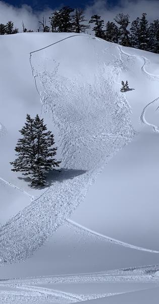
Heightened avalanche conditions exist and there is MODERATE danger for avalanches in the Logan area backcountry today. It is possible to trigger soft slab, wind slab, loose dry and/or wet snow avalanches.
Evaluate the snow and terrain carefully.
Low
Moderate
Considerable
High
Extreme
Learn how to read the forecast here
Special Announcements
UAC operating schedule - We will continue issuing regular avalanche forecasts into mid April.
Spring Awareness Campaign - The UAC counts on donations from the backcountry community. We know these are uncertain times and any donation during our awareness campaign will help us continue providing avalanche forecasting and education.
CDC Guidelines - Even in the backcountry and in parking lots, please follow CDC guidelines like limiting group size and keeping a distance of at least 6 feet from other people to protect yourself and others. Read the guidelines HERE.
Taking risks - Be extra conservative to avoid the risk of accidents which can stress the capacity of our medical system.
Skiing and riding at closed ski resorts - Some resorts allow access now and some do not. Please check HERE for the latest info on ski area access.
New to the backcountry (including riding at closed resorts) - Watch the award-winning, 15 minute Know Before You Go video, or take the 5-part, free online-learning series.
Weather and Snow
It's 12°F at the 8400' Tony Grove Snotel. This recent storm brought about 22 inches of snow with close to 2" SWE. There is now 99 inches of total snow. It's 6°F at the 9700' CSI Logan Peak weather station, and northwest winds are currently blowing about 10 mph.
___________________________________________________________________________________________________________________

It will be sunny in the mountains today with a chance for a few afternoon snow showers. 8500' high temperatures of around 29°F and 5 to 15 mph northwest winds are expected. It will be cold in the mountains tonight, with low temperatures expected to be around 19°F. Snow showers are likely tomorrow, with high temperatures near 33°F and west-southwest winds will blow around 15 mph.
Recent Avalanches
Several human-triggered avalanches were reported yesterday. Most were about 10-15 inches deep, 50-80 feet wide and ran between 300-500 vertical feet. These were mostly soft slab and wind slab avalanches of new snow on east facing high elevation slopes with the exception of one on a north facing mid elevation slope.
In some areas the new snow stabilized quickly while on east facing slopes the new snow was still sensitive and reactive yesterday morning in the Central Bear River Range.
We also noticed evidence of widespread natural loose avalanches of new snow on steep slopes that occurred Tuesday night during the height of the storm.
Ad
Avalanche Problem #1
New Snow
Type
Location
Likelihood
Size
Description
With several human triggered avalanches reported yesterday and the new snow failing to stabilize quickly in some areas, it might still be possible to trigger a soft slab or loose snow avalanche today on steep slopes. This problem exists mainly at high elevations as well as east and north facing mid elevations.
It might also be possible to trigger a soft wind slab avalanche on high elevation east facing leeward slopes where light to moderate winds have deposited snow. Watch for cracking as a sign of instability.
Evaluate terrain carefully and continue to practice safe travel protocols to minimize your risk. Staying on slopes less than 30 degrees is the best way to avoid this problem.
Avalanche Problem #2
Wet Snow
Type
Location
Likelihood
Size
Description
Despite the cool mountain temperatures, the high angle of the late-March sun will affect the snow today. Even yesterday the new snow was dampening quickly on slopes hit by direct sun. If you notice the snow feeling dense and moist or you see signs of instability like roller balls or pinwheels, move to lower angle terrain or to a shadier aspect.
General Announcements
EMAIL ADVISORY. If you would like to get the daily advisory by email you subscribe HERE.
Remember your information can save lives. If you see anything we should know about, please help us out by submitting snow and avalanche observations....HERE. You can also call us at 801-524-5304, email by clicking HERE, or include #utavy in your tweet or Instagram.
This forecast is from the USDA Forest Service, which is solely responsible for its content. The forecast describes general avalanche conditions and local variations always occur.
We will update this forecast before about 7:30 tomorrow morning.