Donate to the 2024 Spring Campaign to help rebuild the UAC website.

Forecast for the Logan Area Mountains

Toby Weed
Issued by Toby Weed for
Thursday, March 21, 2019
LOW: The snow is mostly stable and avalanches are unlikely. Clouds and wind will help to keep the snow cool, but temperatures will rise above 40ºF at upper elevations and wet avalanches are possible on some steep slopes. Continue to practice safe backcountry travel protocols and carry and know how to use your avalanche rescue equipment.
  • Use normal caution.
Low
Moderate
Considerable
High
Extreme
Learn how to read the forecast here
Weather and Snow
The Tony Grove Snotel at 8400' reports 29ºF this morning and there is 82" of total snow with 102% of average SWE for the date. It's 24ºF at the 9700' CSI Logan Peak weather station, and east-southeast winds are currently averaging around 25 mph, with gusts to 45 mph. The snow is stable on most slopes this morning, and avalanches are unlikely today with cloud cover and winds to help keep the snow surface cool. But, overnight temperatures only dipped below freezing for a short time at many stations, clouds will trap heat in the atmosphere, the snow surface may become soft and saturated in some areas and potential for wet avalanches cannot be ruled out.

A pacific storm system will bring low elevation rain and mountain snow across much of Utah through Friday. After brief ridging late Friday into Saturday, another pacific storm system will bring widespread precipitation across the state for the upcoming weekend. It'll be partly cloudy and there is a chance for snow showers in the mountains today. High temperatures at 8500' expected be around 40ºF, with 15 to 25 mph east-southeast winds. Snow showers are likely tonight, with 1 to 3 inches possible. Expect low temperatures around 23º F, and 10 to 15 mph east-southeast winds. Snow showers are likely tomorrow, with 1 to 3 inches of accumulation possible. Some thunder and lightning may occur. High temperatures are expected to be around 36ºF, with 10 to 15 mph south winds.
Recent Avalanches
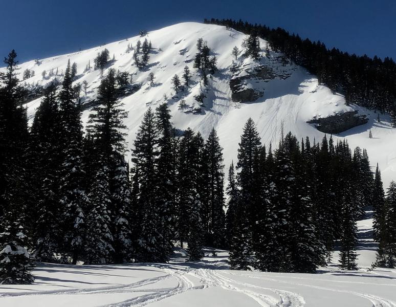
There were a few natural loose wet avalanches in the Logan Zone in the past few days, but these are to be expected as the winter snow is warmed up by the strong March sun.
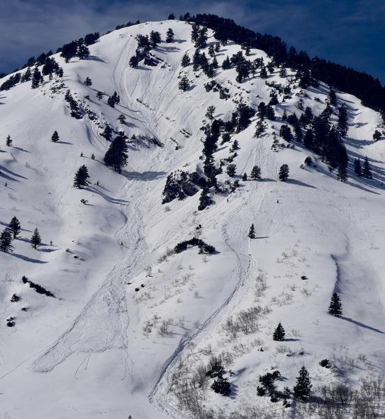
A loose wet avalanche on Andrew Nyman Peak
Ad
Avalanche Problem #1
Normal Caution
Type
Location
Likelihood
Size
Description
  • Avoid and stay out from under large ridge top cornices, which might calve off during the midday heat and could trigger avalanches on steep slopes below.
  • Watch for recently wind drifted snow on isolated steep upper elevation slopes.
  • Always practice safe travel protocols. Go one-at-a-time while the rest of your party watches from a safe place.
  • Check your safety equipment before you head out. Be sure shovel and probe are in good working order and can be assembled. Change the batteries in your beacon.
Avalanche Problem #2
Wet Snow
Type
Location
Likelihood
Size
Description
Avalanches of wet snow will become increasingly possible today as snow becomes melt-softened and saturated. Roller balls, pin wheels, and small natural sluffs indicate potential for loose wet avalanches. You can avoid this problem by getting an early start and leaving the mountains early in the day, before the snow gets too warm.
  • Avoid travel in gullies and stay out from under steep slopes during the heat of the day.
Natural wet avalanches off Mitton Peak in the Wellsville Mountain Wilderness. 3/12/19
Additional Information
I will update this forecast Friday morning.
Enjoy spring skiing at Snowbasin Resort. The UAC has discount Snowbasin tickets available. HERE
General Announcements
The new weather station at the WSU Bloomington Canyon Yurt is up and running. Data available HERE
Now is a great time to practice companion rescue techniques with your backcountry partners. You should check out and use the new Avalanche Beacon Training Park we set up at the Franklin Basin trailhead. Special thanks to Northstars Ultimate Outdoors, USU Outdoor Program, and Beaver Mountain Ski Patrol for helping us to make this possible.
The Beaver Mountain Backside is the backcountry, and it is avalanche terrain. Same goes for the steep rocky terrain adjacent to Cherry Peak Resort. If you leave a ski area boundary, you and your partners should carry and practice with avalanche rescue equipment and follow safe backcountry travel protocols.
Check out the improved weather links, road conditions, and weather links for each forecast region on the new UAC IOS App. Do you use the NOAA point forecast? If so, now you can bookmark your favorite weather locations in "My Weather" in the App. HERE
Are you new to the backcountry or looking to refresh your skills? The UAC has released a free 5-part avalanche skills eLearning series. HERE
If you would like to get the daily advisory by email you subscribe HERE.
Support the UAC through your daily shopping. When you shop at Smith's, or online at REI, Backcountry.com, Patagonia, NRS, Amazon, eBay by clicking on these links, they donate a portion of your purchase to the UAC. If you sell on eBay, you can have your See our Affiliate Page for more details on how you can support the UAC when you shop
Remember your information can save lives. If you see anything we should know about, please help us out by submitting snow and avalanche observations. HERE You can call us at 801-524-5304, email by clicking HERE, or include #utavy in your Instagram.
This forecast is from the U.S.D.A. Forest Service, which is solely responsible for its content. The forecast describes general avalanche conditions and local variations always occur.