Forecast for the Logan Area Mountains

Issued by Toby Weed on
Sunday morning, March 15, 2020
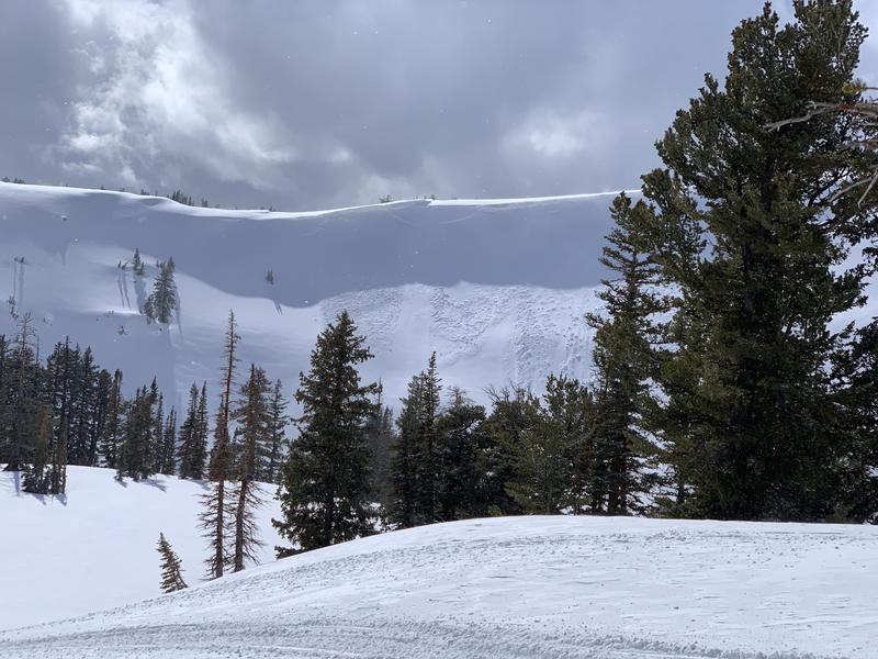
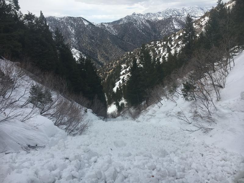
Drifting of yesterday's new snow by strong south winds created heightened avalanche conditions and MODERATE danger on upper and mid elevation slopes. People could trigger soft and harder slabs of wind drifted snow up to around a foot deep. Warm daytime temperatures and rain falling on the snow will create increasing potential for loose avalanches of wet snow on steep slopes.
- Evaluate snow and terrain carefully.

Low
Moderate
Considerable
High
Extreme
Learn how to read the forecast here
Special Announcements
- We know there is a lot of uncertainty regarding the coronavirus, but the Utah Avalanche Center is planning to continue issuing regular avalanche forecasts into April.
- Uphill Travel at Ski Areas - Some resorts will be offering limited uphill access but not all do. Up to date info about uphill access from Ski Utah is posted HERE.
Weather and Snow
Snow showers are happening this morning, and it's 32°F at the 8400' Tony Grove Snotel. About 4 inches fell yesterday at the site, and there is 84 inches of total snow, containing 111% of normal Snow Water Equivalent. It's 26°F at the 9700' CSI Logan Peak weather station, and south winds are currently blowing about 32 mph with a gust of 61 mph earlier this morning.
Looks like a bit more snow fell in the northern part of the zone, but warm temperatures and very strong and sustained south winds yesterday and overnight are certainly doing damage to the fresh snow. Heightened avalanche conditions exist on drifted upper and mid elevation slopes. Temperatures will warm into the mid 40s at upper elevations and some rain is possible, so loose avalanches of wet snow will again become likely in steep terrain.
The low pressure system along the northern California coast will generate a strong and mild southerly flow across Utah through Monday. This low pressure will slowly drift east into the Great Basin and bring the potential for widespread precipitation over Utah midweek. Rain and snow showers are expected today, with little accumulation. It will be mostly cloudy with high temperatures around 43°F at around 8500', with southwest winds blowing about 25 mph along the ridges. A chance of showers will continue tonight. It will be cloudy with low temperatures around 32°F, with 10 to 13 mph southwest wind. Expect snow and rain showers in the mountains again tomorrow, with little accumulation likely, high temperatures again around 43°F, and 10 to 15 mph southwest winds.
Recent Avalanches
Observers reported a couple natural storm slabs and small triggered avalanches of new snow at upper elevations in the Central Bear River Range yesterday.

Last Saturday, a very close call occurred when a skier was caught from behind and carried on top of the wet debris at least 800 vt' in a wet avalanche around 2:30 in the afternoon in the North Syncline Gully. The avalanche occurred on a north facing slope at about 7800' in elevation. The party is unsure if they triggered the avalanche or if it was a natural from above.

Avalanche Problem #1
Wind Drifted Snow
Type

Location

Likelihood

Size

Description
Strong south winds yesterday and overnight created stiff and softer drifts of fresh snow up to about a foot deep, many of which could be sensitive to human triggering today. Heightened avalanche conditions exist in drifted upper and some mid elevation terrain. Drifts formed on the lee sides of ridges and in and around terrain features where decelerating winds deposited the snow.
- Wind drifted snow is often smooth, rounded, and chalky looking, and harder drifts may sound hollow like a drum when you get out them.
- Watch for and avoid fresh drifts on the lee side of major ridge lines and in and around terrain features like cliff bands, scoops, gully walls, and sub-ridges.
- Avoid ridge top cornices, which can break much further back than expected and could start avalanches on slopes below.
Avalanche Problem #2
Wet Snow
Type

Location

Likelihood

Size

Description
Yesterday's new snow quickly became moist with warm temperatures, and shallow loose wet activity is likely on steep slopes where a few inches accumulated. People could trigger loose wet avalanches on steep slopes today. More rain will fall on lower and mid elevation slopes today, and if the wet snow where you are gets soft and unsupportable, it is time to head home.
- Avoid being on or under steep slopes with melt-softened saturated snow.
- Roller balls, pinwheels, and naturally occurring sluffs or other avalanches indicate potential for wet avalanche activity.
Additional Information
Here is what we found in the Central Bear River Range on Tuesday,
General Announcements
Thanks to the generous support of our Utah ski resorts and Ski Utah, we have discount lift tickets available. All proceeds from these go towards paying for avalanche forecasting and education! Get your tickets HERE.
EMAIL ADVISORY. If you would like to get the daily advisory by email you subscribe HERE.
Remember your information can save lives. If you see anything we should know about, please help us out by submitting snow and avalanche observations....HERE. You can also call us at 801-524-5304, email by clicking HERE, or include #utavy in your tweet or Instagram.
This forecast is from the USDA Forest Service, which is solely responsible for its content. The forecast describes general avalanche conditions and local variations always occur.
We will update this forecast before about 7:30 tomorrow morning.