Forecast for the Logan Area Mountains

Toby Weed
Issued by Toby Weed for
Sunday, March 12, 2023
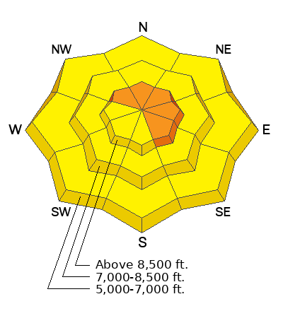
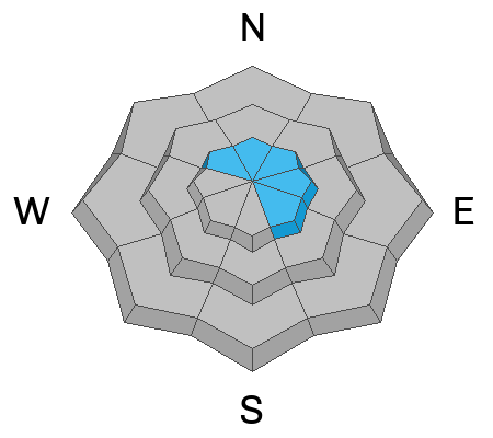
Heightened conditions and MODERATE danger are found at all elevations on backcountry slopes steeper than 30°. Avalanches of wind drifted snow are possible on upper and mid elevation slopes, and loose wet avalanches remain possible on lower elevation slopes with rain-saturated snow. Areas with CONSIDERABLE danger exist on drifted upper elevation slopes facing northwest through southeast, where people are likely to trigger large cornice falls and/or 1 to 3-foot-thick slab avalanches.

Dangerous avalanche conditions exist on upper elevation slopes, so careful snowpack evaluation, cautious route-finding, and conservative decision making are essential.
Low
Moderate
Considerable
High
Extreme
Learn how to read the forecast here
Special Announcements
The UAC is currently working with the operation involved in Thursday's fatal avalanche in the Uintas to prepare a report. Please be patient as we sort out the details of this complicated incident. A preliminary report is available HERE.
Please consider donating to the spring campaign to help our team implement innovative tools and better provide you with the information you rely on.
Weather and Snow
Last week's fine powder conditions are now just a memory, and conditions are completely different this weekend. Heightened avalanche conditions are found in the backcountry, especially in windy terrain, and people need to pay close attention to signs of instability like cracking or collapsing. Colder temperatures overnight probably helped with the wet avalanche problem by freezing up the saturated snow, but warmer daytime temperatures at lower elevations today will revive the concern. Loose wet avalanches could entrain large piles of heavy snow and be a significant risk, especially with terrain traps below steep slopes.

The 8400' Tony Grove Snotel reports well over a foot of heavy snow with 1.7" SWE from Friday's warm storm on top of the 15" of cold light powder from midweek. It's 22° F this morning, and there is 133 inches of total snow. The wind is blowing from the southwest around 20 mph at the 9700' CSI Logan Peak weather station this morning.

Here is the NWS point forecast for high elevations in the Central Bear River Range:
Today: A 50 percent chance of snow, mainly before 3pm. Mostly cloudy, with a high near 29. Wind chill values as low as 9. West southwest wind 7 to 10 mph. Total daytime snow accumulation of 1 to 3 inches possible.
Tonight: A 20 percent chance of snow after 3am. Mostly cloudy, with a low around 21. West southwest wind 8 to 10 mph.
Monday: Snow likely. Mostly cloudy, with a high near 32. West southwest wind around 14 mph. Chance of precipitation is 70%. New snow accumulation of 3 to 5 inches possible.

Unsettled weather will continue, with another stronger wave of stormy weather expected around Tuesday night.
Recent Avalanches
  • Yesterday, we observed evidence of widespread natural avalanche activity from Friday's warm and windy storm across the Logan Zone.
  • For a list of avalanches in the Logan Zone go HERE
  • It was a bit more active in the Wasatch Range yesterday. Find a list of all recent observations & avalanches from across Utah HERE.
Ad
Avalanche Problem #1
Wind Drifted Snow
Type
Location
Likelihood
Size
Description
Avalanches of wind drifted snow, 1 to 3 feet thick, are likely for people to trigger in windy terrain at upper elevations. Drifting of Friday's heavy snow built out already huge cornices and created thick new wind slabs...
  • People could trigger shallow soft slab or loose avalanches on slopes steeper than 30° at mid and upper elevations, even in sheltered terrain.
  • Avoid corniced slopes and stiffer drifts on steep slopes near ridges and in and around terrain features like cliff bands, sub-ridges, mid-slope break-overs, and gully walls.
  • The overhanging cornices on the high peaks and ridges have become huge with recent storms, so its a good idea to continue to stay well away and out from under them.
  • Avalanches of wind drifted snow failing on a persistent weak layer might be triggered remotely or from a distance.
Avalanche Problem #2
Wet Snow
Type
Location
Likelihood
Size
Description
Cooler temperatures and clouds will help with this problem today, but more than normal snow cover exists even at very low elevations and in most areas it was saturated and loosened up by rain on Friday. The snow on most slopes is draining well and it is setting up with the cooler temperatures, but loose avalanches of saturated snow remain possible on steep slopes at lower elevations during the heat of the day.
Additional Information
Natural avalanches were widespread across the Logan Zone during the warm and windy storm on Friday. Here's a look at some evidence in the Wellsville Range as seen under a setting moon.
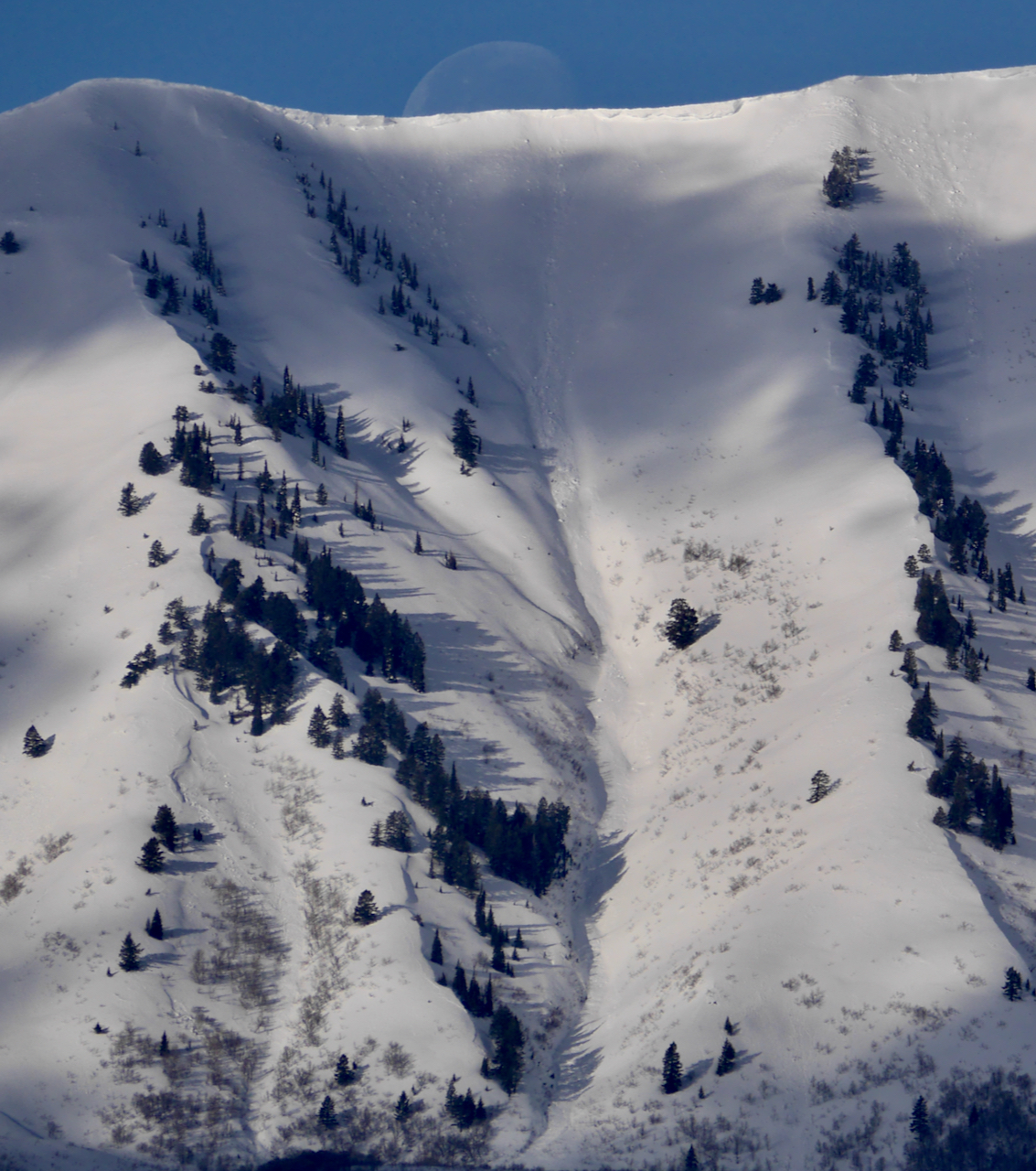
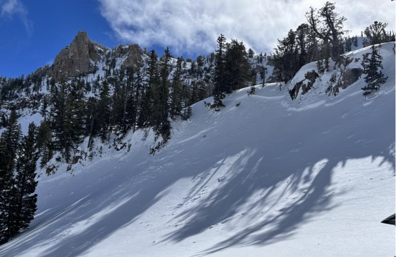
Widespread natural avalanches occurred across the zone with Friday's storm, including some gouging wet loose avalanches, very large cornice falls, and 1 to 2' deep wind/storm slabs, hundreds of feet wide.
General Announcements
  • Please submit your observations from the backcountry HERE.
  • For a list of avalanche classes from the Utah Avalanche Center go HERE
  • For information on where you can ride your sled or snowbike, check out this map of the winter travel plan for the Logan and Ogden Ranger Districts HERE, and a close up of the Tony Grove and Franklin Basin Areas HERE.
This forecast is from the U.S.D.A. Forest Service, which is solely responsible for its content. This forecast describes general avalanche conditions and local variations always occur.