Forecast for the Logan Area Mountains

Toby Weed
Issued by Toby Weed for
Saturday, February 4, 2023
Elevated avalanche conditions and MODERATE danger exist in drifted upper and mid elevation terrain. Drifting by yesterday's wind from the south built stiff wind slabs on weak surface snow. In some areas, people could trigger slab avalanches of wind drifted snow quite easily or remotely, and some might fail on a persistent weak layer buried 1 to 3 feet deep. Large avalanches are unlikely and the danger is mostly LOW at lower elevations and in areas where the wind has not affected the snow.
  • Evaluate snow and terrain carefully.
Low
Moderate
Considerable
High
Extreme
Learn how to read the forecast here
Weather and Snow
The snow is deep and you'll find really nice powder at all elevations in the backcountry, although the sun has moistened/crusted the snow surface on most southerly facing slopes. The new snow has settled significantly over the past few days and stable conditions exist in most areas. Strong winds from the south yesterday drifted snow in exposed terrain and built wind slabs, in some cases on weak surface snow.
The Tony Grove Snotel at 8400' reports 97"of total snow (136% of normal SWE). After howling from the south yesterday, winds at the CSI Logan Peak weather station have subsided and veered from the west, currently 22 mph, and it's 17° F at 9700'.

Today will be sunny and temperatures at 8500' will top out around 31° F, with moderate winds from the west.
Tonight will be mostly cloudy with low temperatures around 18° F and increasing south wind.
Sunday It will snow, with 4 to 8 inches of accumulation and fairly strong winds from the south, (20 to 30 mph), with a high temperature near 30° F.
Moderate snowfall should continue Sunday night and into Monday, with an additional 4 to 9 inches possible.
Recent Avalanches
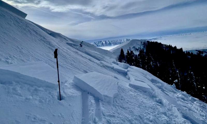
A skier took one step out onto a recently drifted north facing slope on Friday and easily triggered a pretty good sized avalanche of wind drifted snow near the ridge in upper Logan Dry Canyon. We've counted a handful of human triggered avalanches and dozens of large natural avalanches in the Logan Zone due to last weekend's productive storm. For a list of local avalanches go HERE

Find a list of all recent observations & avalanches from across Utah HERE.
A skier took one step onto an obvious fresh wind slab and triggered a good sized avalanche near Logan Peak Friday.
Ad
Avalanche Problem #1
Wind Drifted Snow
Type
Location
Likelihood
Size
Description
Winds blowing from the south yesterday drifted snow into lee slope avalanche starting zones and created stiffer slabs on weak surface snow consisting of small-grained faceted snow and perhaps surface hoar. These fresh wind slabs are likely to still be pretty sensitive to human triggers today, and some avalanches could be remotely triggered, from a distance.
  • Avoid corniced slopes and stiffer drifts on steep slopes near ridges and in and around terrain features like cliff bands, sub-ridges, mid-slope break-overs, and gully walls.
  • The fresh drifts are pretty obvious today but don't be fooled into trusting them. Some wind slabs formed on weak surface snow and could be quite sensitive, while other harder slabs may allow a person to get well out on them before releasing like a mouse trap.
  • The good news is riding conditions are excellent on lower angle slopes, especially in shaded, northerly terrain where surface hoar is present.
Avalanche Problem #2
Normal Caution
Type
Location
Likelihood
Size
Description
In most areas out of the wind the snow is fairly stable and large avalanches are unlikely. Of course, people should use normal caution, travel with good partners one at a time and have the proper gear because although avalanches may be unlikely, LOW danger doesn't mean NO danger...
  • There are areas where weak surface snow was buried and preserved by last week's storm snow. We're finding a buried persistent weak layer consisting of sugary faceted snow, and in many cases, associated with a thin sun-crust. A party of skiers triggered an avalanche failing on this PWL on Tuesday. Conditions have become more stable in recent days, but people should be aware that this persistent weak layer still may be active in some areas, especially where wind drifted snow sits on top of it.
  • As the powerful sun moistens the snow surface, loose avalanches entraining wet snow are possible on very steep, sunny slopes at all elevations. In shady terrain loose dry sluffs of recrystallized powder snow are possible. On sustained slopes loose avalanches can pick up speed and volume pretty quickly. You should stay out from under your partners and other parties and avoid very steep terrain where you could be swept into trees, gullies or other terrain traps.
Additional Information
General Announcements
  • Please submit your observations from the backcountry HERE.
  • For a list of avalanche classes from the Utah Avalanche Center go HERE
  • For information on where you can ride your sled or snowbike, check out this map of the winter travel plan for the Logan and Ogden Ranger Districts HERE, and a close up of the Tony Grove and Franklin Basin Areas HERE.
This forecast is from the U.S.D.A. Forest Service, which is solely responsible for its content. This forecast describes general avalanche conditions and local variations always occur.