Forecast for the Logan Area Mountains

Toby Weed
Issued by Toby Weed for
Saturday, February 25, 2023
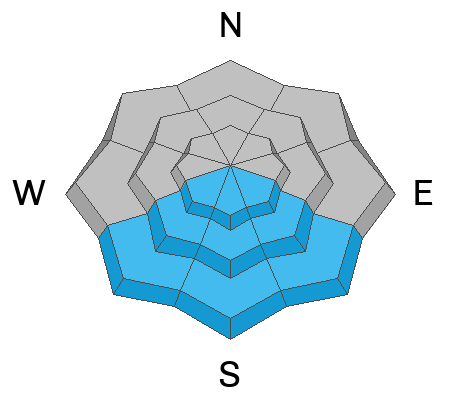
Heightened avalanche conditions exist on drifted slopes at all elevations in the backcountry. People could trigger 2 to 3 foot thick slab avalanches of wind drifted snow on slopes steeper than 30°. Avalanches are more likely and the danger is CONSIDERABLE in windy terrain at upper elevations, where strong winds from the south built out cornices and deposited thick wind slabs. Elevated conditions are also found at lower elevations in areas where drifted snow continues to overload slopes with buried layers of weak sugary snow. Solar warming today will elevate the danger of loose wet avalanches in sunny terrain.
  • Make conservative decisions and evaluate snow and terrain carefully.
Low
Moderate
Considerable
High
Extreme
Learn how to read the forecast here
Weather and Snow
Thursday, I spotted evidence of a widespread natural avalanche cycle in the Wellsville Range, with fresh and snow-covered crowns and debris, including quite a few slides at lower elevations below 7000'. Yesterday, I looked at a few natural avalanches that had occurred around Garden City, and observers reported evidence of natural activity in the canyon mouths and unstable conditions in the foothills. Avalanches are still possible today in areas where a slab of wind drifted storm snow is forming on a slope with poor snow structure. I plan to continue to stay off and out from under drifted slopes steeper than 30°.
The 8400' Tony Grove Snotel reports a couple feet of new snow from this week's storm, with 2.6" SWE. It's 22° F this morning, and there is 109 inches of total snow. The wind is blowing from the south at 35 to 40 mph and gusting close to 60 mph at the CSI Logan Peak weather station at 9700'.
Here is the NWS point forecast for high elevations in the Central Bear River Range:
Today: Mostly sunny, with a high near 32. Wind chill values as low as -1. Southwest wind 13 to 17 mph.
Tonight: A 30 percent chance of snow after 5am. Mostly cloudy, with a low around 18. Wind chill values as low as 6. South wind 11 to 14 mph. New snow accumulation of less than a half inch possible.
Sunday: Snow, mainly after 8am. The snow could be heavy at times. High near 28. Wind chill values as low as 2. Breezy, with a south wind 11 to 16 mph becoming west southwest 23 to 28 mph in the afternoon. Chance of precipitation is 90%. New snow accumulation of 4 to 8 inches possible.

The bulk of Sunday's storm will mostly pass to the south, but a foot or two of new snow could fall at upper elevations in the Bear River Range by Monday afternoon.
Recent Avalanches
Natural avalanches were common at lower elevations with this week's big storm, and they occurred in and around neighborhoods, breaking in backyards and sliding down into areas frequented by folks who usually don't have to worry much about avalanches. Yesterday, we observed recent natural avalanches in lower Green Canyon and up in Garden City.
There was an extensive natural avalanche cycle on the eastern slopes of the Wellsvilles between Tuesday PM and Thursday AM, including dozens of slab avalanches at lower elevations <7000'. report and pictures HERE
For a list of avalanches in the Logan Zone go HERE Find a list of all recent observations & avalanches from across Utah HERE.
Ad
Avalanche Problem #1
Wind Drifted Snow
Type
Location
Likelihood
Size
Description
This morning winds are still blowing from the south, and they increased another notch overnight. Way more than strong enough to drift even the heavy powder. Avalanches of wind drifted storm snow, 2 to 3 feet thick, are possible on drifted slopes at all elevations, but will be larger and more likely for people to trigger on upper elevation slopes facing west, north, and east.
  • Avoid corniced slopes and stiffer drifts on steep slopes near ridges and in and around terrain features like cliff bands, sub-ridges, mid-slope break-overs, and gully walls.
  • Wind slabs consist of stiffer drifted snow. Today, soft and hard slab avalanches of drifted storm snow are possible.
  • Some wind slab avalanches could fail on a sugary persistent weak layer, and some might be triggered remotely.
  • Stay well clear of the freshly swollen cornices, which are likely to break further back than you might expect and could trigger wind slab avalanches below.
Avalanche Problem #2
Persistent Weak Layer
Type
Location
Likelihood
Size
Description
There were many lower elevation areas with very weak faceted snow before the storm capped it with new snow. We found weak layers on and near the surface of the snow prior to this week's storm at all elevations, but the snow was particularly weak and faceted in protected lower elevation terrain, and poor snow structure and unstable snow can be found now on many lower elevation slopes.
  • Avalanches failing on a persistent weak layer are possible at all elevations but are notably also possible down lower, below about 7000' elevation.
  • Avalanches of wind drifted snow could be triggered remotely or from a distance.
Avalanche Problem #3
Wet Snow
Type
Location
Likelihood
Size
Description
  • Loose wet avalanches entraining big piles of moist snow from this week's storm are possible in the middle of the day on steep sunny slopes, especially in areas protected from the wind.
  • Even small wet avalanches can be a problem, especially if you get carried into trees, gullies, benches, or rocks.
Additional Information
Natural avalanches of wind drifted snow in the neighborhood. Garden City 2-24-23
I observed evidence of a widespread natural avalanche cycle at lower elevations in the Logan Zone that occurred from Tuesday afternoon through Thursday morning. This is at the mouth of Green Canyon.
General Announcements
  • Please submit your observations from the backcountry HERE.
  • For a list of avalanche classes from the Utah Avalanche Center go HERE
  • For information on where you can ride your sled or snowbike, check out this map of the winter travel plan for the Logan and Ogden Ranger Districts HERE, and a close up of the Tony Grove and Franklin Basin Areas HERE.
This forecast is from the U.S.D.A. Forest Service, which is solely responsible for its content. This forecast describes general avalanche conditions and local variations always occur.