Forecast for the Logan Area Mountains

Toby Weed
Issued by Toby Weed for
Friday, February 24, 2023
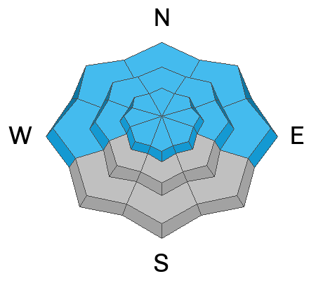
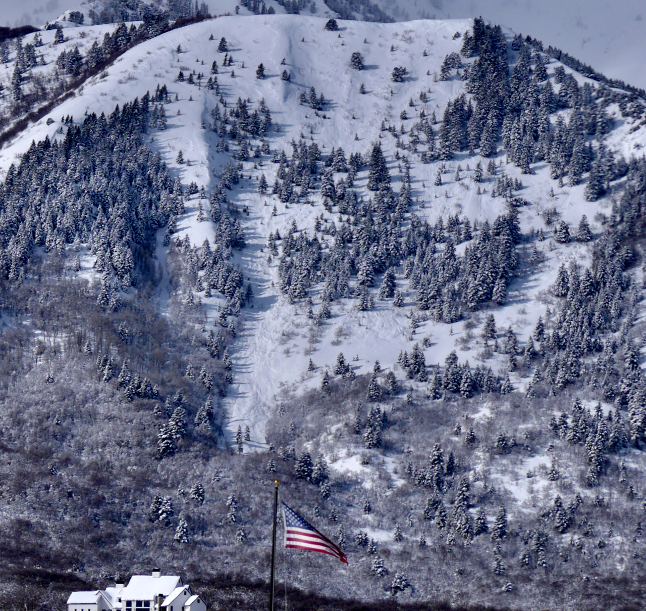
There is CONSIDERABLE avalanche danger at all elevations in the backcountry. Natural avalanches are possible and people are likely to trigger 2 to 3 foot thick slab avalanches of drifted snow on slopes steeper than 30°. Avalanches are more likely in windswept terrain at upper elevations, but dangerous conditions are also found at lower elevations in areas where drifted powder snow continues to overload slopes with buried layers of weak sugary snow.
  • Make conservative decisions and evaluate snow and terrain carefully.
Low
Moderate
Considerable
High
Extreme
Learn how to read the forecast here
Weather and Snow
There were many lower elevation areas with very weak faceted snow before the storm capped it with new snow, and poor snow structure now exists now on many lower and mid elevation slopes. Yesterday, I spotted evidence of a widespread natural avalanche cycle in the Wellsville Range, with fresh and snow-covered crowns and debris, including quite a few slides at lower elevations below 7000'. Avalanches are still likely today in areas where a slab of wind drifted storm snow is forming on a slope with poor snow structure. I plan to continue to stay off and out from under drifted slopes steeper than 30°.
The 8400' Tony Grove Snotel reports a couple feet of new snow from this week's storm, with 2.5" SWE. It's 7° F this morning, and there is 111 inches of total snow. The wind is blowing from the south at around 20 mph at the CSI Logan Peak weather station at 9700'.
Here is the NWS point forecast for high elevations in the Central Bear River Range:
Today: A 40 percent chance of snow, mainly before 11am. Mostly cloudy, with a high near 21. Wind chill values as low as -7. Breezy, with a southwest wind 10 to 15 mph increasing to 18 to 23 mph in the afternoon. Total daytime snow accumulation of around an inch possible.
Tonight: Mostly cloudy, with a low around 12. Wind chill values as low as -3. South southwest wind around 17 mph.
Saturday: A 20 percent chance of snow before 11am. Mostly sunny, with a high near 33. Wind chill values as low as 4. South wind 10 to 15 mph.
A storm Sunday will mostly pass to the south, but a foot to a foot-and-a-half of new snow could fall at upper elevations in the Bear River Range by Monday morning.
Recent Avalanches
Natural wet loose avalanches occurred at lower elevations Tuesday as rain saturated the snow. Observers Wednesday in the Logan Zone reported obvious signs of instability including extensive audible collapsing and cracking at lower and mid elevations. Yesterday, we couldn't see much in the Bear River Range due to the weather, but small natural loose and small soft slab avalanches of storm snow were widespread in steep terrain.
There was an extensive natural avalanche cycle on the eastern slopes of the Wellsvilles between TuePM and ThurAM, including dozens of slab avalanches at lower elevations <7000'. report and pictures HERE
Skiers Wednesday triggered a couple good sized slab avalanches at lower elevations in the nearby backcountry above Ogden Valley..... report HERE

For a list of avalanches in the Logan Zone go HERE Find a list of all recent observations & avalanches from across Utah HERE.
Ad
Avalanche Problem #1
Wind Drifted Snow
Type
Location
Likelihood
Size
Description
This morning winds are blowing from the south, moderate, but still more than strong enough to drift the fresh light powder. Avalanches of wind drifted storm snow, 1 to 3 feet thick, are quite possible on drifted slopes at all elevations, but will be larger and more likely at upper elevations.
  • Avoid corniced slopes and stiffer drifts on steep slopes near ridges and in and around terrain features like cliff bands, sub-ridges, mid-slope break-overs, and gully walls.
  • Before yesterday's storm shallow wind slabs formed on weak surface snow. These are now buried by storm snow but could still be sensitive to triggering by people. Avalanches could be triggered remotely or from a distance
  • Wind slabs consist of stiffer drifted snow. Today, soft slab avalanches of drifted storm snow are most likely, but some avalanches could also include harder slabs that were formed before the new snow fell.
  • Some natural avalanches could run far, threatening people from above.
Avalanche Problem #2
New Snow
Type
Location
Likelihood
Size
Description
  • Soft slab and loose avalanches of storm snow are possible for people to trigger in steep terrain, even in sheltered areas.
  • Natural avalanches of storm snow are becomming less likely as snowfall diminishes today but they're still possible at all elevations.
  • Loose wet avalanches entraining big piles of moist storm snow are possible on steep sunny slopes if the sun pops out for a while later today.
  • Even small avalanches can be a problem, especially if you get carried into trees, gullies, benches, or rocks.
Additional Information
I observed evidence of a widespread natural avalanche cycle in the Wellsville Range that occurred from Tuesday night through Thursday Morning and included dozens of slab avalanches at lower elevations, <7000'
General Announcements
  • Please submit your observations from the backcountry HERE.
  • For a list of avalanche classes from the Utah Avalanche Center go HERE
  • For information on where you can ride your sled or snowbike, check out this map of the winter travel plan for the Logan and Ogden Ranger Districts HERE, and a close up of the Tony Grove and Franklin Basin Areas HERE.
This forecast is from the U.S.D.A. Forest Service, which is solely responsible for its content. This forecast describes general avalanche conditions and local variations always occur.