Donate to the 2024 Spring Campaign to help rebuild the UAC website.

Forecast for the Logan Area Mountains

Toby Weed
Issued by Toby Weed for
Thursday, February 23, 2023
There is CONSIDERABLE avalanche danger at all elevations in the backcountry. People are likely to trigger 1 to 2 foot thick slab avalanches of storm snow on slopes steeper than 30°, natural avalanches are possible and could run far, threatening people from above. Avalanches are more likely on drifted slopes and at upper elevations, but dangerous conditions are also found at lower elevations in areas where drifted storm snow is now overloading slopes with buried layers of weak sugary snow.
  • Make conservative decisions and evaluate snow and terrain carefully. Avoid steep drifted slopes and stay clear of avalanche runouts.
Low
Moderate
Considerable
High
Extreme
Learn how to read the forecast here
Weather and Snow
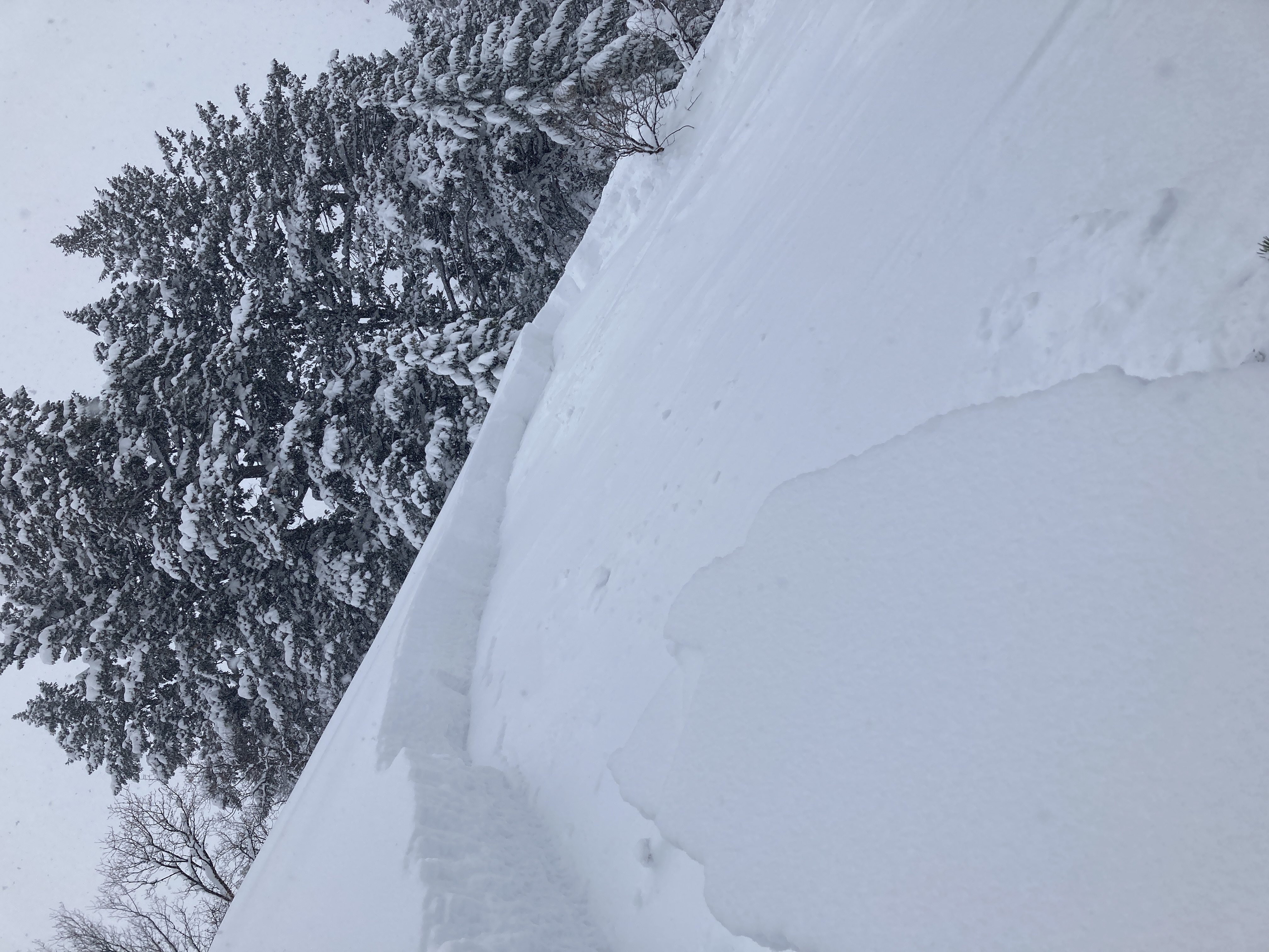
I'm not sure how widespread Tuesday's rain was, but there were many lower elevation areas with very weak faceted snow before the storm capped it all with the new snow. Clearly poor snow structure exists now on many lower elevation slopes, and whether or not the sugary snow got saturated and is now refreezing is another question. Not many people got out yesterday, but reports from the lower and mid elevations in the backcountry include red flags, collapsing!, and cracking indicating unstable snow. So, watch for and avoid drifted areas where a slab of wind drifted storm snow has formed on a slope with poor snow structure. Better yet, just simply avoid and stay out from under slopes steeper than 30°, which is my plan for today.
The 8400' Tony Grove Snotel reports 19 inches of new snow from the storm so far, with 2.2" SWE. It's 9° F this morning, and there is 111 inches of total snow. Winds blowing from the south-southwest picked up a notch late last night at the CSI weather station at 9700' on Logan Peak, and this morning they are blowing 25 mph, with gusts of 45 mph.

Here is the NWS point forecast for high elevations in the Central Bear River Range:
Today: Snow likely, mainly after 11am. Mostly cloudy, with a high near 16. Wind chill values as low as -12. Southwest wind 16 to 20 mph. Chance of precipitation is 70%. Total daytime snow accumulation of 1 to 3 inches possible.
Tonight: Snow likely, mainly before 11pm. Mostly cloudy, with a low around 6. Wind chill values as low as -12. Southwest wind 13 to 18 mph. Chance of precipitation is 60%. New snow accumulation of 2 to 4 inches possible.
Friday: A 50 percent chance of snow. Mostly cloudy, with a high near 22. Wind chill values as low as -4. Breezy, with a southwest wind 10 to 15 mph increasing to 17 to 22 mph in the afternoon. New snow accumulation of around an inch possible
Cold cloudy weather and snow without significant accumulations will continue into the weekend. Saturday, temperatures will warm to around freezing at upper elevations. Looks like another potent storm is possible early next week.
Recent Avalanches
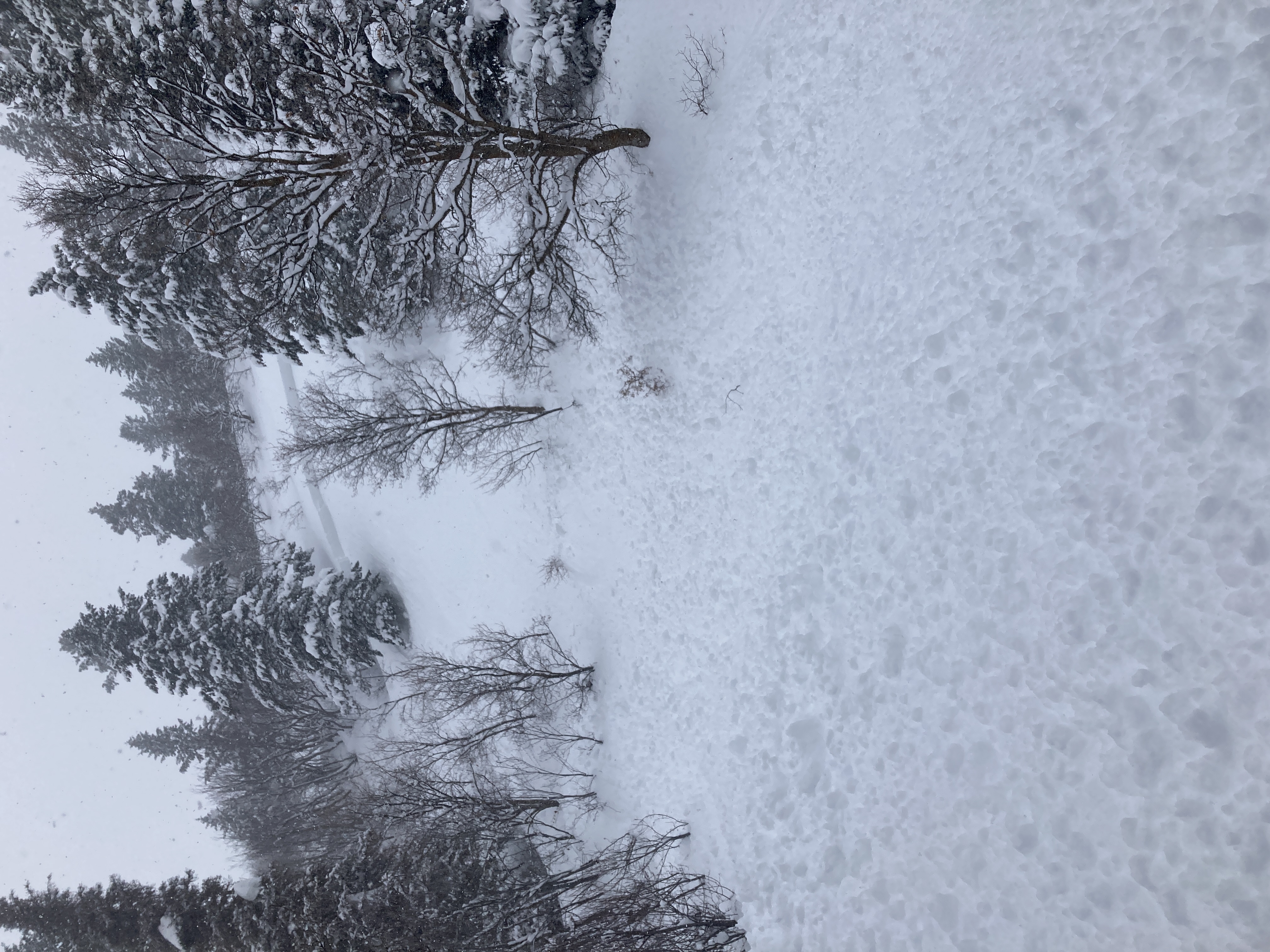
Natural wet loose avalanches occurred at lower elevations Tuesday as rain saturated the snow. Observers yesterday in the Logan Zone reported obvious signs of instability including extensive audible collapsing and cracking at lower and mid elevations.
Skiers yesterday triggered a couple good sized slab avalanches at lower elevations in the nearby backcountry above Ogden Valley..... report HERE

For a list of avalanches in the Logan Zone go HERE
Find a list of all recent observations & avalanches from across Utah HERE.
Ad
Avalanche Problem #1
Wind Drifted Snow
Type
Location
Likelihood
Size
Description
This morning winds are blowing from the southwest, more than strong enough to drift the light powder. Avalanches of wind drifted storm snow, 1 to 2 feet thick, are quite possible on drifted slopes at all elevations, but will be larger and more likely at upper elevations.
  • Avoid corniced slopes and stiffer drifts on steep slopes at all elevations near ridges and in and around terrain features like cliff bands, sub-ridges, mid-slope break-overs, and gully walls.
  • Before yesterday's storm shallow wind slabs formed on weak surface snow. These are now buried by storm snow but could still be sensitive to triggering by people. Avalanches could be triggered remotely or from a distance
  • Wind slabs consist of stiffer drifted snow. Today, soft slab avalanches of drifted storm snow are most likely, but some avalanches could also include harder slabs that were formed before the new snow fell.
  • Some natural avalanches could run far, threatening people from above.
Avalanche Problem #2
New Snow
Type
Location
Likelihood
Size
Description
  • Soft slab and loose avalanches of storm snow are likely for people to trigger in steep terrain, even in sheltered areas.
  • Natural avalanches of storm snow are possible at all elevations, most likely during periods of heavy snowfall and/or drifting.
  • Even small avalanches of wind drifted or loose snow can be a problem, especially if you get carried into trees, gullies, benches, or rocks.
Additional Information
This 2' deep x 100' wide avalanche was remotely triggered by skiers yesterday at lower elevations above the Ogden Valley
General Announcements
  • Please submit your observations from the backcountry HERE.
  • For a list of avalanche classes from the Utah Avalanche Center go HERE
  • For information on where you can ride your sled or snowbike, check out this map of the winter travel plan for the Logan and Ogden Ranger Districts HERE, and a close up of the Tony Grove and Franklin Basin Areas HERE.
This forecast is from the U.S.D.A. Forest Service, which is solely responsible for its content. This forecast describes general avalanche conditions and local variations always occur.