Donate to the 2024 Spring Campaign to help rebuild the UAC website.

Forecast for the Logan Area Mountains

Toby Weed
Issued by Toby Weed for
Friday, February 22, 2019
CONSIDERABLE: Strong east winds overnight created areas with dangerous avalanche conditions on drifted upper elevation slopes. Avalanches and cornice falls consisting of wind drifted snow are possible on many slopes, and may occur in unusual or unexpected places. Fine powder is plentiful in the backcountry, and you can find safer conditions, mostly stable snow, and generally Low danger at lower elevations, in sheltered terrain, and on slopes less than about 30 degrees in steepness.
  • Make conservative decisions, evaluate snow and terrain carefully, and use extra caution if traveling at upper elevations.
  • Beware of large ridge-top cornices and steep slopes with recent deposits of wind drifted snow.
Low
Moderate
Considerable
High
Extreme
Learn how to read the forecast here
Weather and Snow
There's fine powder and plenty of safe places to enjoy it this weekend in the Logan backcountry, but strong east winds overnight, drifted fresh snow at upper elevations into unusual and perhaps unexpected places. Avalanche conditions are a bit tricky up high, with wind drifted snow our biggest concern. I am still finding areas with poor snow structure and although unlikely, dangerous deep hard slab avalanches failing on a sugary persistent weak l;ayer near the ground remain possible for someone to trigger on isolated very steep shallow, rocky, treed, or wind-scoured slopes.

The Tony Grove Snotel at 8400' reports 1" of new snow in the past 24 hours. It's 10º F this morning and there's 87" of total snow containing 104% of average SWE for the date. It's 1º F, at the 9700' CSI Logan Peak weather station, and east-northeast winds are diminishing bit this morning after howling along the high ridges overnight, currently averaging around 25 mph, with a 61 mph gust early this morning.
The storm system that has been impacting the area will start to shift east today. High pressure aloft will spread into the area tomorrow, with a transition to a more westerly flow for the early part of next week. Snow showers are possible this morning, but it'll be mostly sunny in the mountains today. High temperatures at 8500' are expected to be around 16º F, and with 10 to 15 mph north-northwest winds, wind chills will be around -14º F. Tonight will be partly cloudy and temperatures will be around 1º F, with 10 mph west-northwest winds, wind chills are expected to be around -16º F. Mostly cloudy tomorrow, with a chance of a little snow, high temperatures around 18º F, and gradually increasing 15 to 22 mph west winds.
Recent Avalanches
Numerous natural avalanches involving heavy, drifted, and rain-saturated snow from a Valentines Day natural cycle were observed on slopes at all elevations across the Logan Zone. Observers report triggering small soft slabs and sluffs including the soft new snow in steep terrain in the past couple days.
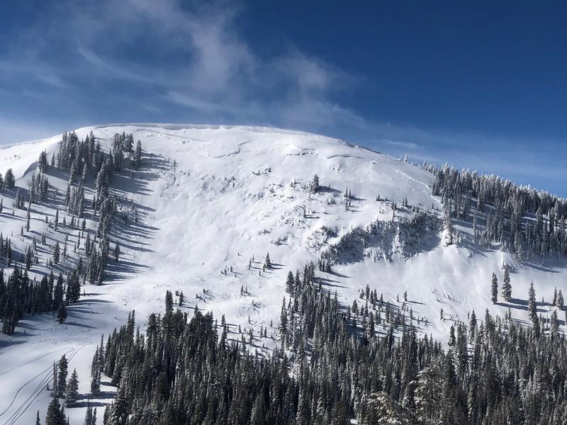
This large natural hard slab avalanche was observed Friday afternoon in upper Providence Canyon. The crown looks to be 6 to 8 feet deep and it's about 1000' wide.
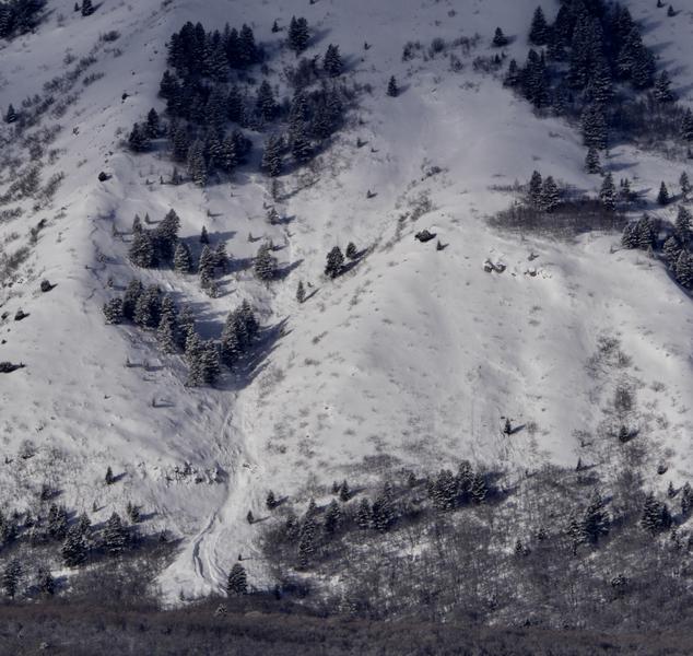
There were several large avalanches at low elevations on the east side of the Wellsville Range involving wind drifted and rain saturated new snow. This one is at around 6000' on Maple Bench.
Ad
Avalanche Problem #1
Wind Drifted Snow
Type
Location
Likelihood
Size
Description
East winds picked up overnight and there's plenty of fresh transportable snow to drift at upper elevations. Strong east winds, blowing in the opposite direction of the normal prevailing winds, created drifts in unusual and unexpected places. Snow was drifted directly into west facing avalanche starting zones and cross-loaded on north and south facing slopes. Heightened avalanche conditions exist on drifted upper and mid-elevation slopes, and areas with more dangerous conditions likely developed overnight in some places. Avalanches involving wind drifted snow could be small, soft, easily triggered, and manageable. or harder, larger, and much more dangerous. Hard wind slabs sometimes let people get out on them before releasing.
  • You should stay clear of ridge top cornices, which have grown quite large in places. Cornices are likely to break much further back than expected and may trigger large avalanches on steep slopes below.
  • Avoid wind drifted snow on the lee side of major ridges and in and around terrain features like sub-ridges, scoops, stringers, cliff bands, and gullies.
Avalanche Problem #2
Persistent Weak Layer
Type
Location
Likelihood
Size
Description
It's unlikely for a person to trigger one, but dangerous avalanches failing on a buried persistent weak layer remain possible on isolated slopes with poor snow structure. Dangerous 2 to 5 feet deep hard slab avalanches are possible to trigger from a shallow area on the slope, and some might be triggered remotely, from a distance, or below. Be especially careful in areas with shallow snow cover or anywhere where you sink to the ground in weak snow when you get off your sled or skis. Hard deep slab avalanches might be triggered from a shallower part of the slab.
  • Continue to avoid wind drifted snow on very steep, rocky, or shallow slopes with poor snow structure.
Additional Information
I will update this forecast tomorrow morning.
The new weather station at the WSU Bloomington Canyon Yurt is up and running. Data available HERE
Now is a great time to practice companion rescue techniques with your backcountry partners. You should check out and use the new Avalanche Beacon Training Park we set up at the Franklin Basin trailhead. Special thanks to Northstars Ultimate Outdoors and USU Outdoor Program for helping us to make this possible.
General Announcements
The Beaver Mountain Backside is the backcountry, and it is avalanche terrain. Same goes for the steep rocky terrain adjacent to Cherry Peak Resort. If you leave a ski area boundary, you and your partners should carry and practice with avalanche rescue equipment and follow safe backcountry travel protocols.
Check out the improved weather links, road conditions, and weather links for each forecast region on the new UAC IOS App. Do you use the NOAA point forecast? If so, now you can bookmark your favorite weather locations in "My Weather" in the App. HERE
Are you new to the backcountry or looking to refresh your skills? The UAC has released a free 5-part avalanche skills eLearning series. HERE
If you would like to get the daily advisory by email you subscribe HERE.
Support the UAC through your daily shopping. When you shop at Smith's, or online at REI, Backcountry.com, Patagonia, NRS, Amazon, eBay by clicking on these links, they donate a portion of your purchase to the UAC. If you sell on eBay, you can have your See our Affiliate Page for more details on how you can support the UAC when you shop
Remember your information can save lives. If you see anything we should know about, please help us out by submitting snow and avalanche observations. HERE You can call us at 801-524-5304, email by clicking HERE, or include #utavy in your Instagram.
This forecast is from the U.S.D.A. Forest Service, which is solely responsible for its content. The forecast describes general avalanche conditions and local variations always occur.