There's fine powder and plenty of safe places to enjoy it this weekend in the Logan backcountry, but strong east winds Thursday night and Friday, drifted fresh snow at upper elevations into unusual and perhaps unexpected places. Avalanche conditions are a bit tricky up high, with wind drifted snow your biggest concern. I am still finding areas with poor snow structure and although unlikely, dangerous deep hard slab avalanches failing on a sugary persistent weak l;ayer near the ground remain possible for someone to trigger on isolated very steep shallow, rocky, treed, or previously wind-scoured and now wind-loaded slopes.
The Tony Grove Snotel at 8400' reports 8º F this morning and there's 86" of total snow containing 103% of average SWE for the date. It's 0º F, at the 9700' CSI Logan Peak weather station, and west-southwest winds are currently averaging around 25 mph, with a 44 mph gust early this morning.
The National Weather Service in Pocatello has issued a Winter Storm Warning for the Bear River Range in SE Idaho due to a long term snow event beginning tomorrow. High pressure aloft will spread into the area today, with a transition to a more westerly flow Sunday through the early part of next week. Snow showers are possible and it'll be mostly cloudy in the mountains today. High temperatures at 8500' are expected to be around 17º F, and with 15 to 25 mph southwest winds, gusting to around 40 mph, wind chills will be around -18º F. Tonight will be mostly cloudy with a good chance for 1 to 3 inches of snow. Temperatures will rise to around 17º F, with 25 mph southwest winds and gusts around 40 mph. Snow is likely tomorrow, with 3 to 7 inches possible, and it'll be windy, with 25 to 35 mph southwest winds and gusts approaching 50 mph.
Observers on Friday reported recent natural wind slab activity at upper elevations in the Mount Naomi Wilderness.
Numerous natural avalanches involving heavy, drifted, and rain-saturated snow from a Valentines Day natural cycle were observed on slopes at all elevations across the Logan Zone. Backcountry riders and skiers report triggering small soft slabs and sluffs including the soft new snow in steep terrain in the past week.
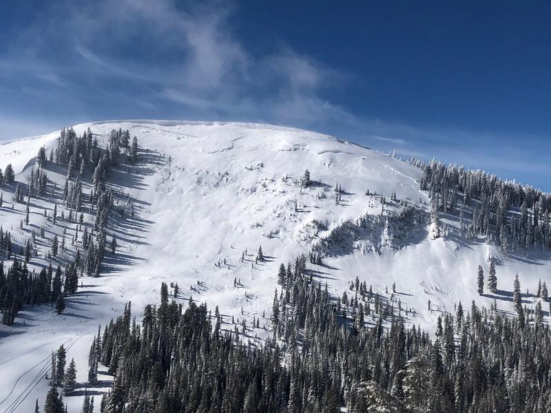
This large natural hard slab avalanche was observed last Friday in upper Providence Canyon. The crown looks to be 6 to 8 feet deep and it's about 1000' wide.