Forecast for the Logan Area Mountains

Toby Weed
Issued by Toby Weed for
Sunday, February 18, 2024
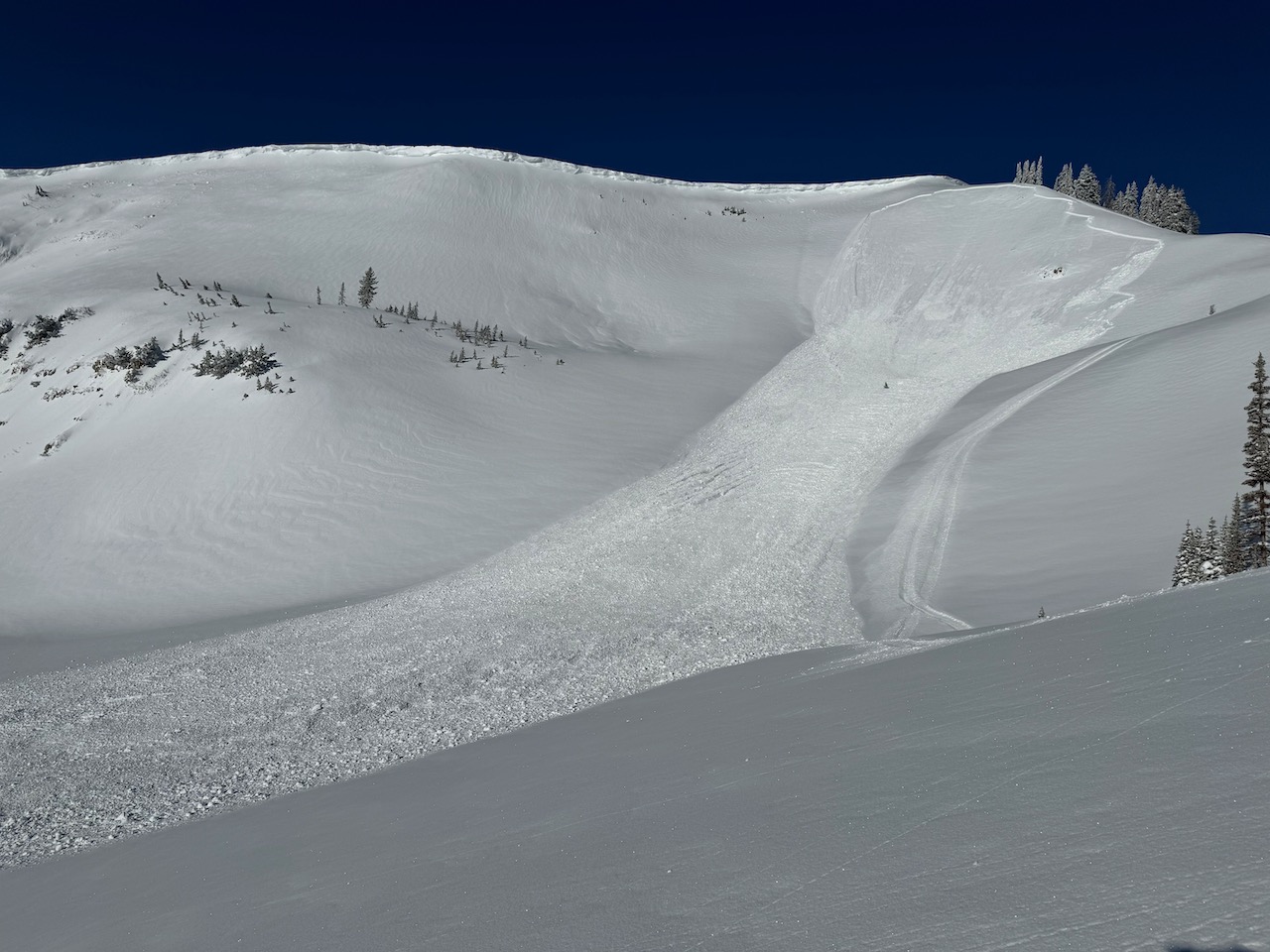
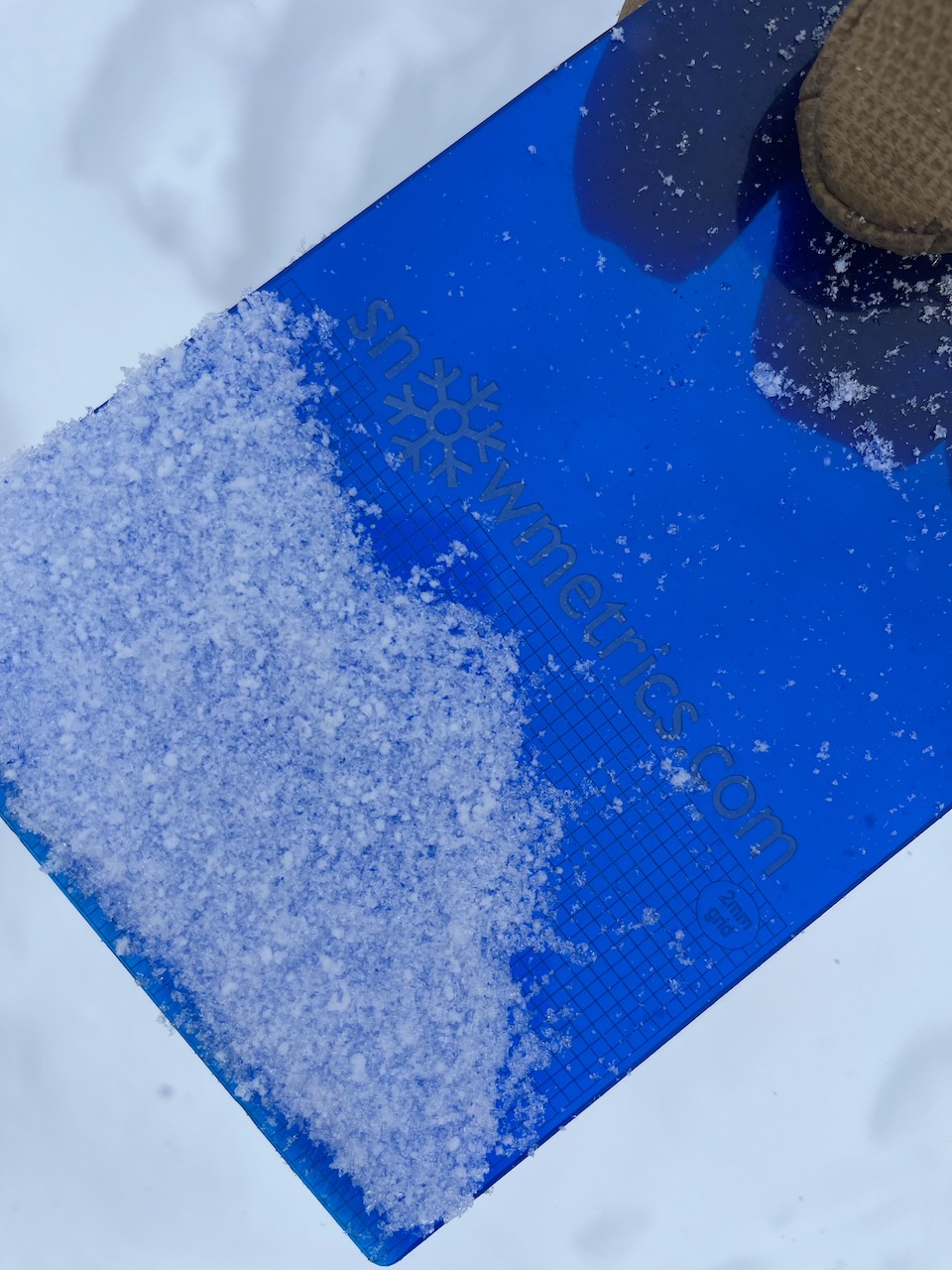
Today, periods of heavy snowfall and drifting by strong winds out of the west will elevate the avalanche danger, and human-triggered avalanches are possible on many slopes steeper than 30°. A CONSIDERABLE danger exists in drifted upper elevation terrain, where natural avalanches are possible and people are likely to trigger avalanches of wind-drifted snow failing up to 2 feet deep on a thin, persistent weak layer.

Careful snowpack evaluation, cautious route-finding, and conservative decision-making are essential for safe backcountry travel.
Low
Moderate
Considerable
High
Extreme
Learn how to read the forecast here
Special Announcements
We are seeking a passionate individual to join us as Executive Director of the nonprofit Utah Avalanche Center. Click here for more information.
Want to learn more about how to stay safe from avalanches while riding in the backcountry? Join us Feb 23-24 for an Introduction to Avalanche class. Information and registration here.
Weather and Snow
Nice, fast powder conditions exist across the Logan Zone, and safe slopes less steep than 30° and open meadows offer really good riding options. Yesterday, observers reported numerous small natural avalanches and obvious signs of instability like collapsing or whumpfs and shooting cracks. Again today, human-triggered slab avalanches up to 2 feet deep are likely on drifted upper-elevation slopes steeper than 30°.

The Tony Grove Snotel at 8400' reported 21 inches of new snow that accumulated Thursday and Friday, with 3.1" SWE (snow water equivalent). It's 20° F, there is an inch of new snow, and there is 93" of total snow. The wind is blowing from the south this morning around 30 mph, with gusts of over 50 mph at the 9700' CSI Logan Peak weather station. At 9500' on Paris Peak, winds from the south-southwest are blowing around 10 mph, and it's 20° F.
Today, snow is expected in the mountains, with 4 to 8 inches of accumulation possible at around 8500' in elevation. High temperatures around 30° F and 15 to 22 mph winds blowing from the west are expected. Tonight will be partly cloudy with low temperatures around 16° F and 11 to 20 mph winds from the west. Snow is expected to resume tomorrow with 1 to 3 inches of accumulation possible and 13 to 23 mph winds from the south-southwest.
Snow will continue on and off and it could be heavy at times through Wednesday in the mountains, with significant incremental accumulation possible.
Recent Avalanches
Numerous 1 to 2-foot deep natural avalanches were observed at upper elevations across the zone yesterday morning on east through south-facing slopes. Yesterday morning, a possibly remotely triggered slide was observed on Cornice Ridge on a SE facing slope at 9600' in elevation. The avalanche was estimated to be 18" deep and 150' wide. Riders reported remotely triggering a good-sized avalanche in Three Terraces Bowl in upper Providence Canyon on the east side of Providence Peak on a southeast-facing slope at around 9500' (~2' deep and 200' wide, running around 700vrt'), and the party noted several recent naturals.
Check out local observations and avalanches HERE.
Ad
Avalanche Problem #1
Wind Drifted Snow
Type
Location
Likelihood
Size
Description
Drifting by winds from the west in the last couple of days created stiff wind slabs in exposed upper-elevation terrain. In some areas, people are likely to trigger avalanches of wind-drifted snow up to 2 feet deep on drifted slopes steeper than 30°. Avalanches may fail on a thin layer of small-grained, sugary, or faceted snow that was on the snow surface on Wednesday. This is a thin, persistent weak layer, but it should heal or gain strength pretty quickly.
  • Watch for and avoid fresh wind slabs on the lee side of major ridges, corniced slopes, and in and around terrain features like cliff bands, sub-ridges, gully walls, and mid-slope rollovers.
  • Stay well away from and out from under overhanging cornices, which may break further back than expected.
  • Obvious signs of instability include cracking and collapsing, but these red flags may not be present when avalanches occur.
  • Soft slab and loose avalanches of new snow are possible even in more sheltered terrain, and natural avalanches are most likely during periods of particularly heavy snowfall.
Avalanche Problem #2
Persistent Weak Layer
Type
Location
Likelihood
Size
Description
Avalanches of wind-drifted snow may fail up to 2 feet deep on a thin, sugary, persistent weak layer that was on the surface on Valentine's Day and buried by the productive storms on Thursday and Friday. Reports of audible collapsing (whumpfs) and a couple of remotely triggered avalanches on Saturday confirm that this layer may still be unstable in some areas. It appears that the problem is more pronounced in sunny terrain where the thin layer of faceted snow sits atop a supportable melt-freeze crust.
Additional Information
This avalanche in Three Terraces (upper Providence Canyon) was remotely triggered Saturday morning by a rider on a snowmobile.
We found a layer of small-grained, sugary snow at the interface of Wednesday's snow surface and Thursday's new snow. The "Valentines persistent weak layer (PWL)"
General Announcements
-Listen to your very own Logan Zone avalanche forecasters on the UAC Podcast HERE.
-Read my recent blog about wind, drifting, and avalanches HERE.
-Sign up for forecast region-specific text message alerts. You will receive messages about changing avalanche conditions, watches, and warnings...HERE.
-For all questions on forecasts, education, Know Before You Go, events, online purchases, or fundraising, call 801-365-5522.
-To report an avalanche or submit an observation from the backcountry, go HERE.
-Come practice companion rescue at the Franklin Basin TH Beacon Training Park. It's free and open to everyone. For easy user instructions, go HERE.
-Paige will update this forecast by 7:30 AM tomorrow.
This forecast is from the U.S.D.A. Forest Service, which is solely responsible for its content. This forecast describes general avalanche conditions, and local variations always occur.