Donate to the 2024 Spring Campaign to help rebuild the UAC website.

Forecast for the Logan Area Mountains

Toby Weed
Issued by Toby Weed for
Saturday, February 16, 2019
CONSIDERABLE: Beware of large unstable cornices and slopes overloaded by wind drifted snow. Dangerous human triggered avalanches consisting of wind drifted snow remain likely on mid and upper elevation slopes. Some avalanches could fail on a buried persistent weak layer and be deep and destructive, and they might be triggered remotely, from a distance or below.
Cooling is helping to harden and stabilize saturated low elevation snow, and you can find safer conditions at lower elevations, in sheltered terrain, and on slopes less than about 30 degrees in slope steepness.
  • Use extra caution in the backcountry today. Make conservative decisions and evaluate snow and terrain carefully.
  • Avoid and stay out from under large ridge-top cornices and steep slopes with recent deposits of wind drifted snow.
Low
Moderate
Considerable
High
Extreme
Learn how to read the forecast here
Weather and Snow
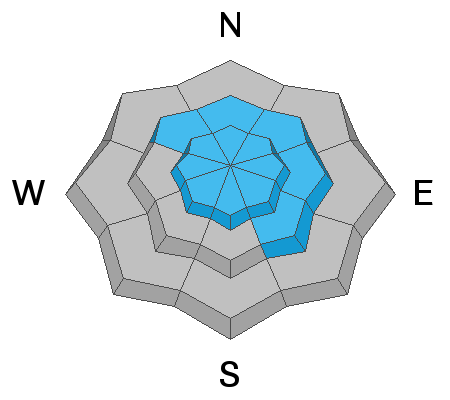
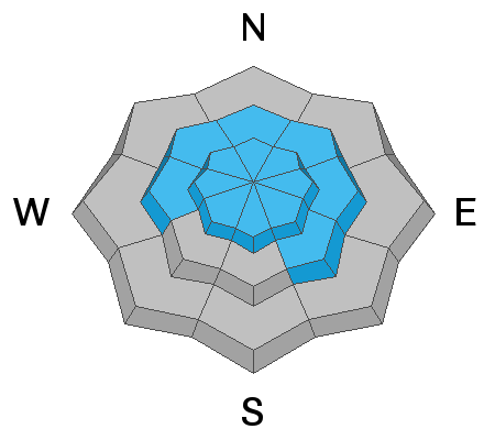
Temperatures at lower elevations have dropped well below freezing, and low elevation snow will harden and stabilize fairly quickly. Winds calmed significantly and veered out of the northwest overnight. Avalanche conditions are improving, but it's still quite dangerous in drifted upper and mid elevation terrain and human triggered avalanches are likely. Avalanche accidents are likely this weekend in the backcountry, so you'll need to use extra caution and continue to avoid and stay out from under steep slopes with recent deposits of drifted snow and large ridge top cornices...

The Tony Grove Snotel at 8400' reports another 6" of accumulation or so, with .5" SWE in the last 24 hours and 4.3" of SWE from the storm. Temperatures cooled to 13º F this morning and there's 88" of total snow containing 108% of average SWE for the date. It's 7º F, at the 9700' CSI Logan Peak weather station. Northwest winds are diminishing a bit, currently averaging around 20 mph, with a recent 40 mph gust.
Cool temperatures and occasional scattered snow showers will linger through the weekend and into early next week as broad troughing continues across the west. A stronger storm system may impact the state late next week. 1 to 3 inches of accumulation is possible today. High temperatures at 8500' expected to be around 19º F, with 15-20 mph west winds. Tonight 1 to 3 inches of accumulation is possible, temperatures will be around 8º F, with 15 mph west winds. Mostly cloudy tomorrow, with high temperatures around 19º F, and light and variable winds.
Recent Avalanches
Numerous natural avalanches involving heavy, drifted, and rain-saturated snow were observed Thursday and yesterday on slopes at all elevations across the Logan Zone.
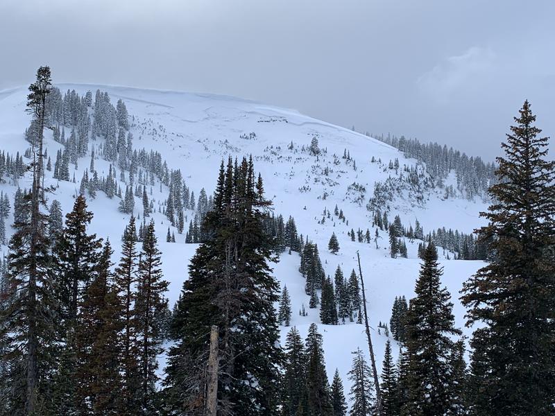
This large natural hard slab avalanche was observed yesterday afternoon in upper Providence Canyon. The crown looks to be 6 or 7 feet deep and it's about 1000' wide.

  • Snowboard riders report easily triggering a few soft slab avalanches involving heavy new snow on the Beaver Mountain Backside Thursday. Remember the Backside is the backcountry. Nobody does avalanche control, and you could certainly trigger dangerous avalanches.
  • The groomer reports several large natural avalanches on the trails east of Hardware Ranch on the Saddle Creek trail between the Danish Dugway and Strawberry Valley.
  • On Tuesday I could see evidence of a recent large and deep natural hard slab avalanche in upper Mill Hollow on a mostly north facing slope at around 8900' in elevation.

Avalanches are dangerous, and sadly there have been four people killed in Utah in the past few weeks. For more info go... HERE There have also been numerous close calls and natural avalanches. Our list is HERE
Ad
Avalanche Problem #1
Wind Drifted Snow
Type
Location
Likelihood
Size
Description
Dangerous avalanche conditions exist on drifted upper and mid-elevation slopes. Avalanches involving wind drifted snow could be quite large and dangerous. You should stay clear of ridge top cornices, which have grown quite large in places. Cornices are likely to break much further back than expected and may trigger large avalanches on steep slopes below.
  • Avoid wind drifted snow on the lee side of major ridges and in and around terrain features like sub-ridges, scoops, stringers, cliff bands, and gullies.
Avalanche Problem #2
Persistent Weak Layer
Type
Location
Likelihood
Size
Description
Dangerous human triggered avalanches consisting of new or wind drifted snow and failing on a buried persistent weak layer are likely.
  • Frost or feathery surface hoar and thick and thinner layers of small-grained near surface facets plagued the snow surface on many slopes before the Superbowl Storm. These are notorious persistent weak layers, and in some areas were buried intact, so the danger of avalanches failing on one will linger for a while.
  • Significant accumulations of SWE added quite a bit of weight to the slab overloading the buried weak snow near the bottom of the snowpack in some places. Dangerous, 3 to 5-foot-deep hard slab avalanches are likely, especially on steep, recently drifted slopes with poor snow structure. In some areas today, you could trigger avalanches remotely, from a distance, or worse from below.
Additional Information
I will update this forecast Monday morning.
The new weather station at the WSU Bloomington Canyon Yurt is up and running. Data available HERE
Now is a great time to practice companion rescue techniques with your backcountry partners. You should check out and use the new Avalanche Beacon Training Park we set up at the Franklin Basin trailhead. Special thanks to Northstars Ultimate Outdoors and USU Outdoor Program for helping us to make this possible.
General Announcements
The Beaver Mountain Backside is the backcountry, and it is avalanche terrain. Same goes for the steep rocky terrain adjacent to Cherry Peak Resort. If you leave a ski area boundary, you and your partners should carry and practice with avalanche rescue equipment and follow safe backcountry travel protocols.
Check out the improved weather links, road conditions, and weather links for each forecast region on the new UAC IOS App. Do you use the NOAA point forecast? If so, now you can bookmark your favorite weather locations in "My Weather" in the App. HERE
Are you new to the backcountry or looking to refresh your skills? The UAC has released a free 5-part avalanche skills eLearning series. HERE
If you would like to get the daily advisory by email you subscribe HERE.
Support the UAC through your daily shopping. When you shop at Smith's, or online at REI, Backcountry.com, Patagonia, NRS, Amazon, eBay by clicking on these links, they donate a portion of your purchase to the UAC. If you sell on eBay, you can have your See our Affiliate Page for more details on how you can support the UAC when you shop
Remember your information can save lives. If you see anything we should know about, please help us out by submitting snow and avalanche observations. HERE You can call us at 801-524-5304, email by clicking HERE, or include #utavy in your Instagram.
This forecast is from the U.S.D.A. Forest Service, which is solely responsible for its content. The forecast describes general avalanche conditions and local variations always occur.