Donate to the 2024 Spring Campaign to help rebuild the UAC website.

Forecast for the Logan Area Mountains

Toby Weed
Issued by Toby Weed for
Friday, February 15, 2019
HIGH: Avalanches involving heavy new snow and wind drifted snow are likely on many mid and upper elevation slopes. Natural activity will become likely again with strong winds and heavy snowfall as a strong cold front passes over the zone. Cooling will help to harden and stabilize the saturated snow at lower elevations, but wet avalanches are still possible in steep terrain.
  • Avoid travel in avalanche terrain.
  • Stay off and out from under slopes steeper than about 30 degrees and well clear of avalanche run-out zones.
Low
Moderate
Considerable
High
Extreme
Learn how to read the forecast here
Avalanche Warning
THE FOREST SERVICE UTAH AVALANCHE CENTER IN SALT LAKE CITY HAS ISSUED A BACKCOUNTRY AVALANCHE WARNING.
* TIMING...THROUGH 6 AM SATURDAY
* AFFECTED AREA...THE MOUNTAINS OF NORTHERN UTAH TO INCLUDE THE BEAR RIVER RANGE AND THE WESTERN UINTAS.
* AVALANCHE DANGER...IS HIGH. BOTH NATURAL AND HUMAN TRIGGERED AVALANCHES WILL BE LIKELY ON MANY ASPECTS AND ELEVATIONS.
* REASON/IMPACTS...STRONG WINDS, ALONG WITH RECENT HEAVY DENSE SNOW AND RAIN ON SNOW AT THE LOWER ELEVATIONS HAS CREATED DANGEROUS AVALANCHE CONDITIONS.
STAY OFF OF AND OUT FROM UNDER SLOPES STEEPER THAN 30 DEGREES. BACKCOUNTRY TRAVELERS SHOULD CONSULT WWW.UTAHAVALANCHECENTER.ORG OR CALL 1-888-999-4019 FOR MORE DETAILED INFORMATION.
THIS WARNING DOES NOT APPLY TO SKI AREAS WHERE AVALANCHE HAZARD REDUCTION MEASURES ARE PERFORMED.
Weather and Snow
West-southwest winds are calming a bit in the mountains and temperatures at lower elevations are slowly dropping, but very dangerous avalanche conditions exist in the backcountry today, and you should continue to avoid travel in avalanche terrain at all elevations.

The Tony Grove Snotel at 8400' reports another foot or so of heavy snow, with 1.3" SWE in the last 24 hours and 3.7" in the last 48. Temperatures cooled to 23º F this morning and there's 87" of total snow containing 108% of average SWE for the date. It's 17º F, at the 9700' CSI Logan Peak weather station. West-southwest winds are diminishing a bit, currently averaging around 20 mph, with a recent 47 mph gust.
A strong cold front will sweep through the region tonight, followed by cold and unsettled weather during the weekend and into early next week. Expect snow this afternoon in the Logan Zone, with 3 to 7 inches of accumulation possible at upper elevations. High temperatures at 8500' expected to be around 26º F, with 15-20 mph southwest winds, increasing in the afternoon. Tonight 3 to 7 inches of accumulation is possible, temperatures will be around 9º F, with 10 to 20 mph west-northwest winds. Snow will continue tomorrow, with 1 or 2 inches, high temperatures around 20º F, and 15 mph west winds.
Recent Avalanches
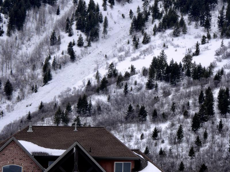
Numerous natural avalanches involving heavy, drifted, and rain-saturated snow were observed yesterday on slopes facing all directions and down to about 5400' in elevation.

  • Snowboard riders report easily triggering a few soft slab avalanches involving heavy new snow on the Beaver Mountain Backside yesterday. Remember the Backside is the backcountry. Nobody does avalanche control, and you could certainly trigger dangerous avalanches.
  • Friday, heli-ski guides remote triggered a large hard slab avalanche failing on a buried persistent weak layer near the ground in the southern Bear River Range. The avalanche was on a northwest facing slope at around 8400' in elevation..
  • On Tuesday I could see evidence of a recent large and deep natural hard slab avalanche in upper Mill Hollow on a mostly north facing slope at around 8900' in elevation.

Avalanches are dangerous, and sadly there have been four people killed in Utah in the past few weeks. For more info go... HERE There have also been numerous close calls and natural avalanches. Our list is HERE
Ad
Avalanche Problem #1
Wind Drifted Snow
Type
Location
Likelihood
Size
Description
Significant accumulations of heavy new snow has caused natural soft slab and loose avalanches on steep slopes at all elevations, even in sheltered terrain... Natural avalanches will become more likely again this afternoon during periods of particularly heavy precipitation
Very dangerous avalanche conditions exist on drifted upper and mid-elevation slopes. Avalanches involving wind drifted snow could be quite large and dangerous. Cornices are likely to break much further back than expected and could be quite large.
  • Avoid wind drifted snow on the lee side of major ridges and in and around terrain features like sub-ridges, scoops, stringers, cliff bands, and gullies.
Avalanche Problem #2
Wet Snow
Type
Location
Likelihood
Size
Description
Rain saturated the snow up to around 7500' in elevation. Wet avalanches entraining large piles of heavy wet snow are possible at lower elevations again today. This morning temperatures in the Valley are still several degrees above freezing, but cooling temperatures this afternoon and evening will begin to harden and stabilize the saturated snow.
Avalanche Problem #3
Persistent Weak Layer
Type
Location
Likelihood
Size
Description
Dangerous natural and human triggered avalanches consisting of new or wind drifted snow and failing on a buried persistent weak layer are likely.
  • Frost or feathery surface hoar and thick and thinner layers of small-grained near surface facets plagued the snow surface on many slopes before the Superbowl Storm. These are notorious persistent weak layers, and in some areas were buried intact, so the danger of avalanches failing on one will linger for a while.
  • Significant accumulations of SWE added quite a bit of weight to the slab overloading the buried weak snow near the bottom of the snowpack in some places. Dangerous, 3 to 5-foot-deep hard slab avalanches are likely, especially on steep, recently drifted slopes with poor snow structure. In some areas today, you could trigger avalanches remotely, from a distance, or worse from below.
Additional Information
I will update this forecast tomorrow morning.
The new weather station at the WSU Bloomington Canyon Yurt is up and running. Data available HERE
Now is a great time to practice companion rescue techniques with your backcountry partners. You should check out and use the new Avalanche Beacon Training Park we set up at the Franklin Basin trailhead. Special thanks to Northstars Ultimate Outdoors and USU Outdoor Program for helping us to make this possible.
General Announcements
The Beaver Mountain Backside is the backcountry, and it is avalanche terrain. Same goes for the steep rocky terrain adjacent to Cherry Peak Resort. If you leave a ski area boundary, you and your partners should carry and practice with avalanche rescue equipment and follow safe backcountry travel protocols.
Check out the improved weather links, road conditions, and weather links for each forecast region on the new UAC IOS App. Do you use the NOAA point forecast? If so, now you can bookmark your favorite weather locations in "My Weather" in the App. HERE
Are you new to the backcountry or looking to refresh your skills? The UAC has released a free 5-part avalanche skills eLearning series. HERE
If you would like to get the daily advisory by email you subscribe HERE.
Support the UAC through your daily shopping. When you shop at Smith's, or online at REI, Backcountry.com, Patagonia, NRS, Amazon, eBay by clicking on these links, they donate a portion of your purchase to the UAC. If you sell on eBay, you can have your See our Affiliate Page for more details on how you can support the UAC when you shop
Remember your information can save lives. If you see anything we should know about, please help us out by submitting snow and avalanche observations. HERE You can call us at 801-524-5304, email by clicking HERE, or include #utavy in your Instagram.
This forecast is from the U.S.D.A. Forest Service, which is solely responsible for its content. The forecast describes general avalanche conditions and local variations always occur.