UDOT PLANNED AVALANCHE CLOSURES!!

Forecast for the Logan Area Mountains

Toby Weed
Issued by Toby Weed for
Sunday, February 12, 2023
Areas with MODERATE danger exist on drifted upper elevation slopes facing west, north, and east, where people could trigger slab avalanches of wind drifted snow. The danger is LOW in sheltered terrain and at mid and lower elevations, where we've found mostly stable snow and nice powder conditions.
  • Evaluate snow and terrain carefully.
Low
Moderate
Considerable
High
Extreme
Learn how to read the forecast here
Weather and Snow
We've been finding really good shallow powder conditions in sheltered northerly terrain and on lower angled slopes, especially at mid and lower elevations. Winds last week damaged the powder in exposed terrain and on many upper elevation slopes, and sun melted and crusted the surface on southerlies.
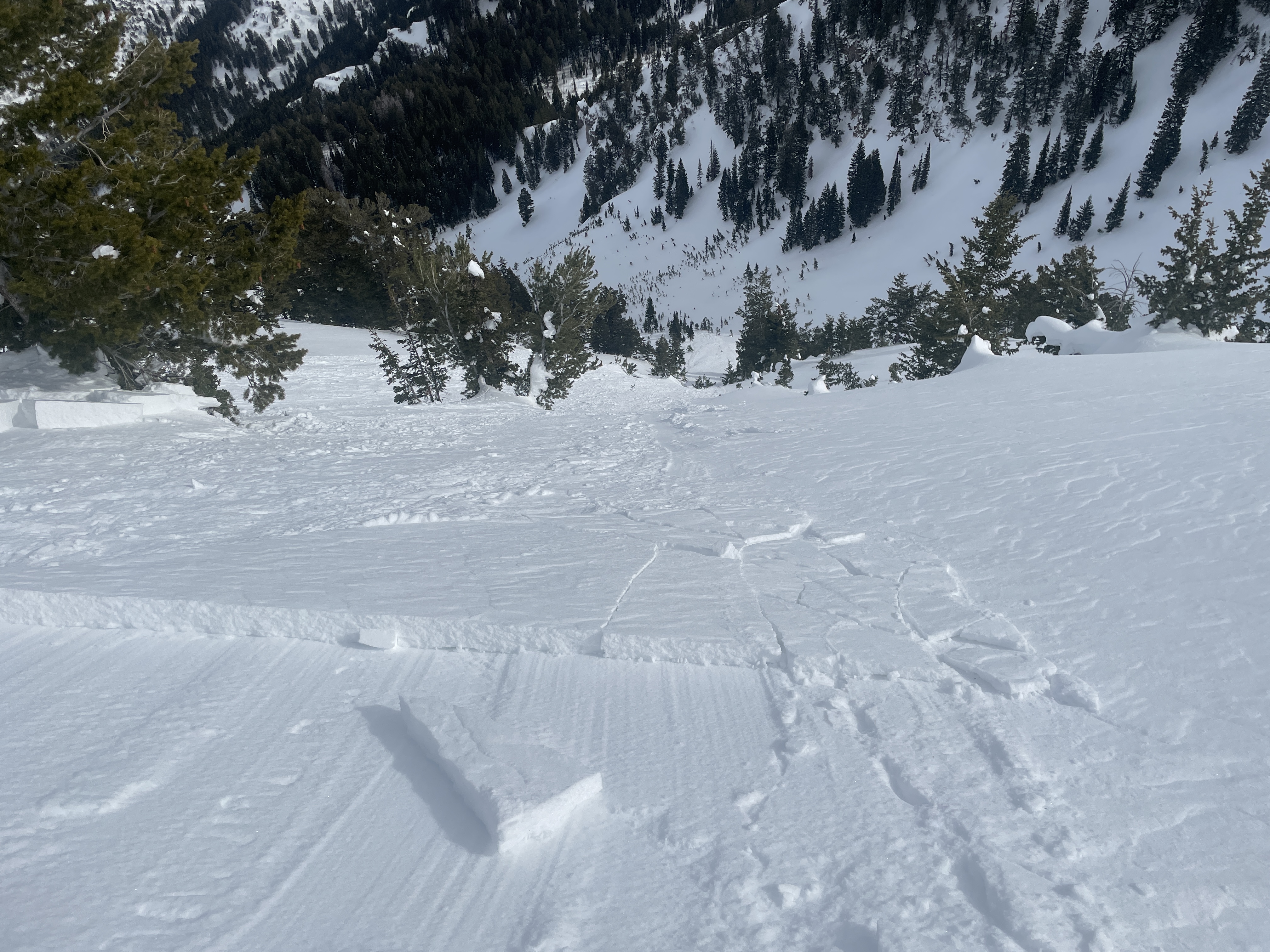
Elevated avalanche conditions exist in drifted upper elevation terrain. Winds blowing from the south picked up steam and drifted snow at upper elevations Friday night, and hard wind slab avalanches are still possible today on drifted northerly facing slopes. Loose avalanches entraining moist surface snow are possible on steep sunny slopes in the middle of the day. These could be a problem if a person were to be swept into trees, gullies, or other terrain traps.

Winds at the 9700' CSI Logan Peak weather station are blowing from the west at 10 to 15 mph this morning The Tony Grove Snotel at 8400' reports 27° F and 96 inches of total (settled) snow.

Today will be sunny, with high temperatures at 8500' around 34°F, with light winds from the north-northeast.
Tonight, expect mostly clear skies, low temperatures around 14° F and winds becoming southeast.
Tomorrow will be sunny, with high temperatures around 31° F, and moderate winds will blow out of the west-southwest 6 to 10 mph.
The next winter storm will impact the area Monday night and Tuesday, with 4 to 8 inches of accumulation possible in the mountains, but the bulk of the storm energy looks to be heading into Central and Southern Utah.
Recent Avalanches
Observers report easily triggering lots of small wind slab avalanches Thursday and Friday on slopes steeper than 30° above about 8600' on east and northeast facing slopes in the Central and Northern Bear River Range. Yesterday, skiers in Mill Hollow remotely triggered a 8" deep and 60' wide wind slab avalanche that ran around 500 vrt'. They also observed a natural avalanche of wind drifted snow on the north side of Logan Peak. Report is HERE

For a list of avalanches in the Logan Zone go HERE
Find a list of all recent observations & avalanches from across Utah HERE.
Ad
Avalanche Problem #1
Wind Drifted Snow
Type
Location
Likelihood
Size
Description
Significant drifting occurred last week elevating avalanche danger in exposed terrain. Winds blowing from the south Friday night, gusting well over 50 mph on Logan Peak, were more than strong enough to drift snow into avalanche starting zones and build hard wind slabs.
  • In some areas, shallow wind slabs formed on weak surface snow and remain sensitive, with shooting cracks an obvious indicator of instability, and numerous small human triggered avalanches of wind drifted snow reported last week. Avalanches might still be triggered remotely, from a distance.
  • Avoid corniced slopes and stiffer drifts on steep slopes near ridges and in and around terrain features like cliff bands, sub-ridges, mid-slope break-overs, and gully walls.
  • Despite the wind, shallow powder riding conditions remain pretty good in lower angled, lower elevation, and sheltered terrain.
Additional Information
Skiers remotely triggered this avalanche of wind drifted snow in Mill Hollow yesterday. The avalanche ran around 500 vrt' and would have been a dangerous ride if anyone had been caught. People could trigger similar avalanches on drifted upper elevation slopes today.
General Announcements
  • Please submit your observations from the backcountry HERE.
  • For a list of avalanche classes from the Utah Avalanche Center go HERE
  • For information on where you can ride your sled or snowbike, check out this map of the winter travel plan for the Logan and Ogden Ranger Districts HERE, and a close up of the Tony Grove and Franklin Basin Areas HERE.
This forecast is from the U.S.D.A. Forest Service, which is solely responsible for its content. This forecast describes general avalanche conditions and local variations always occur.