It is Avalanche Awareness Week! Events are happening daily across the state to prepare you for winter and get you thinking about avalanche safety. Find out about all our events
HERE. And don't forget the
Utah Snow and Avalanche Workshop is Saturday, December 6, with in-person and virtual options!
Our 22nd annual Pray 4 Snow fundraiser-party was a huge success thanks to you....
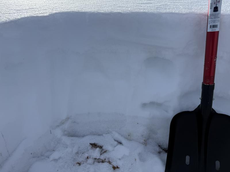
The Tony Grove Snotel at 8400' reports 15 inches of total snow, and it's 17° F. The recent snow from earlier in the week is subject to rapid temperature-gradient metamorphism caused by the cold temperatures. The December snow caps shallow, sugary, and very weak faceted snow from November that exists on slopes facing all directions above about 8000' in elevation. On high northerly-facing slopes, a hard layer of refrozen October snow makes up the base layer. A westerly wind picked up again overnight, and this morning, it's blowing 20 to 35 mph on Logan Peak and 20 to 30 mph from the west-southwest on Paris Peak. Temperatures range from around 11° F on the mountain tops to 22° F down in Logan.
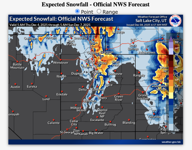
The National Weather Service has issued a Winter Storm Watch for the northern mountains, including the Logan Zone, for late tonight through Saturday evening.
*This from this morning's NWS forecast discussion: "A significant winter storm will impact northern and central Utah late Thursday into Sunday morning. The potential for unsettled weather continues through the middle of next week."
In the Logan Zone: At upper elevations today, skies will be partly sunny, with a high near 23° F. Expect increasing winds from the west, 6 to 14 mph. There's a chance of some snow in the afternoon, but it won't really start to accumulate till tonight. *Heavy snowfall is possible tonight, with 5 to 9 inches of accumulation possible. Low temperatures will be around 18° F, and winds will blow from the west-southwest 10 to 13 mph. *Tomorrow it will snow heavily at times, with 6 to 10 inches of accumulation possible. High temperatures are expected to rise to around 26° F, and west-southwest winds will blow 10 to 16 mph It will be partly sunny, with high temperatures near 19° F. Expect increasing westerly winds...
***Heavy snowfall is expected to continue through Saturday in the Logan Zone, with very heavy snowfall possible Friday night. A couple of feet of new snow could accumulate in the higher terrain of the Central Bear River Range by Saturday morning. This will significantly elevate avalanche danger in the backcountry.
No avalanches have been reported recently in the Logan Zone. For observations and avalanche activity, go
HERE