Forecast for the Logan Area Mountains

Toby Weed
Issued by Toby Weed for
Wednesday, December 19, 2018
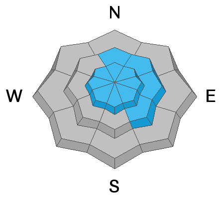
MODERATE: Heightened avalanche conditions exist on drifted upper elevation slopes, and you could trigger avalanches involving wind drifted snow. Drifting will continue today and danger will increase in some exposed terrain. Wind slab avalanches failing on a shallowly buried sugary persistent weak layer are possible. Dangerous deep slabs releasing on larger grained depth hoar near the ground are unlikely but still possible in isolated upper elevation terrain with poor snow structure.
Evaluate snow and terrain carefully.
Low
Moderate
Considerable
High
Extreme
Learn how to read the forecast here
Weather and Snow
West winds howled along the ridges overnight, drifting the shallow new snow at upper elevations and creating heightened avalanche conditions. The Tony Grove Snotel reports an angry one inch of new snow overnight with .3" SWE (Snow Water Equivalent). There's 34"of total snow, containing 88% of average SWE for the date. Temperatures are dropping this morning at 8400', and it's currently 25º F. West winds picked up in the evening at the CSI Logan Peak weather station and sustained 25 to 30 mph speeds all night. I'm currently reading 30 mph northwest winds with gusts in the 50s. It's 20º F at 9700'.
You can find good access and pretty good coverage for this time of year, but the snow is still just a bit too shallow to ride in steep terrain or to get aggressive with your throttle.

A fast moving weather disturbance will impact the region today. Strong high pressure aloft over the region Thursday will be replaced by a series of weather disturbances moving east through the area beginning Friday. We'll see a bit of snow in the mountains today, with cloudy skies and temperatures at 8500' around 26º F and 21 to 31 mph west wind, gusting around 45 mph. It'll be partly cloudy tonight, low temperature around 15º F, and decreasing southwest wind, 7 to 12 mph after midnight. Tomorrow will be sunny with a chance of snow showers, high temperature near 36º F, and 11 to 17 mph south-southwest wind.
Recent Avalanches
There was some natural avalanche activity due to wind drifted snow on steep upper elevation slopes in the central Bear River Range during the intense storm last Wednesday, 12/12/18
Ad
Avalanche Problem #1
Wind Drifted Snow
Type
Location
Likelihood
Size
Description
You could trigger avalanches consisting of wind drifted snow. Drifting from west winds occurred in exposed terrain overnight, and heightened avalanche conditions exist on upper elevation slopes. Drifting will continue today and conditions could become more dangerous as drifts get deeper and more widespread.
  • Watch for and avoid fresh or older drifts on the lee sides of major ridges and in and around terrain features like cliff bands, scoops, gullies, stringers, and sub-ridges.
  • Avoid steep slopes that have a smooth, rounded appearance, or that sound hollow like a drum.
Avalanche Problem #2
Persistent Weak Layer
Type
Location
Likelihood
Size
Description
A shallowly buried layer of sugary faceted snow called near surface facets was buried by last week's storm and it could become active on some drifted slopes. Although rather unlikely, dangerous human triggered hard slab avalanches failing on a persistent weak layer near the ground called depth hoar are still possible on upper elevation slopes with poor snow structure.
  • Collapsing and cracking indicate that the snow is unstable.
  • Avoid steep shady or rocky terrain at upper elevations.
Sugary, faceted snow from early November creates a persistent weak layer near the ground on upper elevation slopes facing the north half of the compass.
Additional Information
I will update this advisory on Friday morning.
General Announcements
The new UAC IOS mobile app is now available on the app store. Check out the new "My Weather" feature. HERE
Check out the new free online avalanche course series developed by the Utah Avalanche Center. This is a great way to refresh your skills or prepare you for a Backcountry 101 or Level 1 class. HERE
Now is a great time to practice companion rescue techniques with your backcountry partners. Here is our practice video.
If you would like to get the daily advisory by email you subscribe HERE.
Support the UAC through your daily shopping. When you shop at Smith's, or online at REI, Backcountry.com, Patagonia, NRS, Amazon, eBay by clicking on these links, they donate a portion of your purchase to the UAC. If you sell on eBay, you can have your See our Affiliate Page for more details on how you can support the UAC when you shop
Remember your information can save lives. If you see anything we should know about, please help us out by submitting snow and avalanche observations. HERE You can call us at 801-524-5304, email by clicking HERE, or include #utavy in your Instagram.
This advisory is from the U.S.D.A. Forest Service, which is solely responsible for its content. This advisory describes general avalanche conditions and local variations always occur.