Get Your Ticket to the 32nd Annual Backcountry Benefit on September 11th! Support Forecasting, Awareness, and Education
Ad

Forecast: Logan Area Mountains

Forecast for the Logan Area Mountains

Toby Weed
Issued by Toby Weed on
Tuesday morning, January 7, 2020
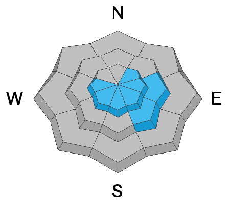
Areas with CONSIDERABLE danger exist on upper elevation east facing slopes. Heightened avalanche conditions also exist on many other drifted upper and mid elevation slopes in the backcountry. People could trigger avalanches of wind drifted snow today, and some avalanches could fail on a persistent weak layer. You can find safer conditions, LOW danger, and mostly stable snow at lower elevations, and in lower angled and sheltered terrain.
  • Evaluate snow and terrain carefully. Use caution while route finding at upper elevations, and make conservative decisions.
Low
Moderate
Considerable
High
Extreme
Learn how to read the forecast here
Weather and Snow
It's 18°F at the 8400' Tony Grove Snotel this morning, and there is about 11 inches of new snow, with 1.1" SWE in the past 48 hours. There is 58 inches of total snow, with 115% of average SWE for the date. Much less snow fell at lower elevations and at other snow sites in the area, with about .5" SWE the average. It's 17°F at the CSI weather station at 9700' on Logan Peak, and it's still pretty windy. Southwest winds are currently blowing 25 to 30 mph and gusting to 40 mph.
Strong westerly winds messed with the nice powder at upper elevations and on exposed slopes, but almost a foot of nice new snow from yesterday will refresh conditions nicely. Areas with dangerous conditions exist on drifted upper elevation slopes facing east, and people could trigger serious avalanches in the backcountry. You can find pretty nice shallow powder and much safer conditions at lower elevations, in lower angled and sheltered terrain.
Nice and smooth, but somewhat shallow snow at lower elevations in East Wood Camp.

It'll be mostly sunny in the mountains today, with 8500' high temperatures around 33°F and 11 to 14 mph southwest wind. It will be mostly cloudy tonight, with low temperatures expected to be around 17°F, rising to around 26°F during the night, with 11 to 15 mph southwest winds. Snow showers are expected tomorrow, with 3 to 5 inches of accumulation possible. High temperatures will around 26°F in the morning, falling to around 19°F during the rest of the day, and we'll see 14 to 18 mph west-southwest winds. Active weather is expected to continue through the weekend, with the next weak storm expected Thursday night and Friday.
Recent Avalanches
A close call occurred Saturday (1-4-2020) when a party of 4 riders triggered a sizable avalanche of wind drifted snow at about 9000' on an east facing slope above Hidden Lake in Gibson Basin, a couple miles north of the state line out of Beaver Creek Canyon. One rider was caught, carried, and partially buried. The avalanche was about 2' deep and around 150' wide.
Ad
Avalanche Problem #1
Wind Drifted Snow
Type
Location
Likelihood
Size
Description
People are likely to trigger 1 to 3 foot deep avalanches of wind drifted snow on upper elevation slopes facing the eastern half of the compass today. Avalanches are possible on many other slopes as well.
  • Watch for and avoid stiffer drifted snow near ridge lines and in and around terrain features like cliff bands, scoops, gully walls, and sub-ridges.
  • Wind slabs are often rounded and chalky looking, and they might sound hollow, like a drum.
  • Soft fresh wind slabs can be quite sensitive, and are often remotely triggered. Hard wind slabs can be more devious, sometime allowing one to get out on them before releasing.
  • Avoid ridge top cornices, which can break much further back than expected and start avalanches on slopes below.
Avalanche Problem #2
Persistent Weak Layer
Type
Location
Likelihood
Size
Description
Human triggered avalanches failing on a newly buried persistent weak layer are possible on slopes steeper than about 30 degrees at upper and mid elevations. The cold weather last week created sugary weak surface snow in many areas, and some slopes were plagued by feathery surface hoar. A persistent weak layer associated with a thin sun-crust appears to be active on drifted sunny slopes in many areas across Northern Utah. Some avalanches today might be triggered remotely, from a distance or below. Some slopes in the area may stay unstable for a while.

Persistent weak layers consisting of feathery surface hoar and sugary near surface facets were buried by the New Years Storm on many slopes, and some of these may stay unstable for a while.
We found widespread weak sugary snow under crusts at lower elevations in the Wood Camp area yesterday. The sugary or faceted snow is stable for now, but quite weak, and we could see problems in the future if lower elevation slopes are overloaded by heavy snow.
Additional Information
We had a great time with the Avalanche 101 class up at Tony Grove on Saturday....
General Announcements
Thanks to the generous support of our Utah ski resorts and Ski Utah, we have discount lift tickets available. All proceeds from these go towards paying for avalanche forecasting and education! Get your tickets HERE.
EMAIL ADVISORY. If you would like to get the daily advisory by email you subscribe HERE.
Remember your information can save lives. If you see anything we should know about, please help us out by submitting snow and avalanche observations....HERE. You can also call us at 801-524-5304, email by clicking HERE, or include #utavy in your tweet or Instagram.
This forecast is from the USDA Forest Service, which is solely responsible for its content. The forecast describes general avalanche conditions and local variations always occur.
I will update this forecast before about 7:30 tomorrow morning.