Forecast for the Logan Area Mountains

Toby Weed
Issued by Toby Weed for
Tuesday, January 31, 2023
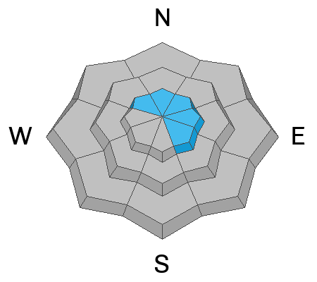
There is CONSIDERABLE danger at upper elevations on slopes facing northwest through southeast. People are likely to trigger slab avalanches of wind drifted snow 3 to 4 feet thick failing on a buried persistent weak layer. The danger is MODERATE on south and west facing slopes and at mid elevations where human triggered wind slab and loose avalanches remain possible on slopes steeper than about 30°. The snow is mostly stable at lower elevations.
  • Careful snowpack evaluation, cautious route finding, and conservative decision making are required for safe travel in avalanche terrain.
Low
Moderate
Considerable
High
Extreme
Learn how to read the forecast here
Weather and Snow
You'll find really nice deep and cold powder at all elevations in the backcountry. It's perhaps a bit crusty or moist on south facing slopes due to the increasingly powerful sun. I've noted a fair amount of settlement in the new snow, and it is rapidly becoming more stable in most areas.
The Tony Grove Snotel at 8400' reports over three feet of new snow from last weekend's storm with 4.3 inches of SWE (Snow Water Equivalent). This morning the temperature is -4° F, and there is now 103 inches of total snow. The CSI Logan Peak weather station at 9700' is showing winds blowing from the west-northwest this morning around 25 mph with -3° F.

Today will be sunny but stay very cold, temperatures at 8500' will top out around 12° F and moderate winds blowing from the west will create wind chill values around -17° F.
Tonight will be partly cloudy, with steady temperatures around 5° F, and 8 mph winds from the west will bring wind chill values down to around -11° F.
Tomorrow will be mostly sunny, with high temperatures around 22° F, and winds blowing from the west-southwest around 10 mph.
It looks like gradual warming as the work week progresses and possibility of a little snow on Friday. A stronger storm looks to be brewing for early next week.
Recent Avalanches
Saturday, hikers remotely triggered a large hard wind slab avalanche on an east facing slope at around 7700' near the Bear Lake Overlook. The avalanche was 3 to 4 feet deep and close to 200' wide. Report is HERE.
A widespread natural avalanche cycle occurred across the Logan Zone late Saturday night and Sunday morning, and numerous storm slab and loose avalanches can be seen at all elevations in the Wellsville and Bear River Mountains. Of note is a large natural avalanche observed on Mt. Magog, 3 to 4' deep and several hundred feet wide, on a southeast facing slope at around 9500' in elevation report is HERE

Find a list of all observations & avalanches from across Utah HERE.
Ad
Avalanche Problem #1
New Snow
Type
Location
Likelihood
Size
Description
Since cold weather is in the forecast, it's likely that the powder will stay really good for a while, and it'll be worth waiting for a little while longer for it to stabilize in steep drifted terrain.
  • Copious new snow from the weekend has created potential for human triggered avalanches, especially in areas where the snow is drifted onto slopes steeper than about 30°.
  • Loose avalanches entraining powder snow remain possible on very steep slopes at all elevations. Despite the cold temperatures, on sheltered sunny slopes wet (or moist) sluffs entraining lots of fresh snow are possible as the powerful sun moistens the new snow surface. On sustained slopes these can pick up speed and volume pretty quickly. People should stay out from under your partners and other parties and avoid very steep terrain where you could be swept into trees, gullies or other terrain traps.
Avalanche Problem #2
Wind Drifted Snow
Type
Location
Likelihood
Size
Description
People are likely trigger slab avalanches of wind drifted storm snow up to three feet thick in drifted terrain. Sustained winds from the west enlarged cornices and built fresh wind slabs. Some of these probably formed on weak surface snow that was preserved by a couple inches of powder last week and could remain pretty touchy.
  • Avoid corniced slopes and stiffer drifts on steep slopes near ridges and in and around terrain features like under cliff bands, sub-ridges, mid-slope break-overs, and gully walls.
Avalanche Problem #3
Persistent Weak Layer
Type
Location
Likelihood
Size
Description
There are areas where weak surface snow was buried and preserved by light powder last week. We're finding a new buried persistent weak layer consisting of sugary faceted snow, in some cases associated with a thin sun-crust. This is the culprit failing layer in several recent close calls with avalanches in the Wasatch Range and it appears to be present in the Bear River Range as well.
The evidence of a persistent weak layer is fairly clear:
  1. An observer triggered a couple audible collapses Sunday on mid elevation south and west facing slopes. Snow pit tests confirm propegating tendancies and the presence of a buried weak layer.
  2. Hikers remotely triggered a 3-4 foot thick hard wind slab avalanche on Saturday. The avalanche failed on a thin layer of sugary faceted snow.
  3. A large recent natural avalanche, 3 to 4 feet deep and a few hundred feet wide was observed on Mt. Magog. The size of this avalanche indicates that it likely failed on a PWL.
  • This type of persistent weak layer usually doesn't remain unstable for very long, but people should be aware that it may be active in some areas still.
Additional Information

A natural avalanche on Mt. Magog. (1-30-23, C. Hawley)
Several recent natural avalanches are visible looking up Brushy Canyon in the Wellsville Mountain Wilderness...
General Announcements
  • Please submit your observations from the backcountry HERE.
  • For a list of avalanche classes from the Utah Avalanche Center go HERE
  • For information on where you can ride your sled or snowbike, check out this map of the winter travel plan for the Logan and Ogden Ranger Districts HERE, and a close up of the Tony Grove and Franklin Basin Areas HERE.
This forecast is from the U.S.D.A. Forest Service, which is solely responsible for its content. This forecast describes general avalanche conditions and local variations always occur.