UDOT PLANNED AVALANCHE CLOSURES!!

Forecast for the Logan Area Mountains

Toby Weed
Issued by Toby Weed for
Wednesday, February 1, 2023
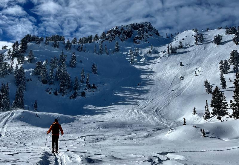
There is MODERATE danger on upper and mid elevation elevations slopes steeper than 30°. Elevated avalanche conditions exist, and people could trigger slab avalanches of wind drifted snow failing on a persistent weak layer buried 1 to 3 feet deep. Loose avalanches entraining significant volumes of powder or moist snow are possible in very steep terrain. The snow is mostly stable at lower elevations.
  • Evaluate snow and terrain carefully
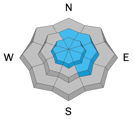
Low
Moderate
Considerable
High
Extreme
Learn how to read the forecast here
Weather and Snow
You'll find really nice deep and cold powder at all elevations in the backcountry. We found a thin sun crust on southerly facing slopes at all elevations yesterday. I've noted lots of settlement in the recent snow, and it is stable in most areas. The exceptions are avalanches failing on a persistent weak layer buried 1 to 3 feet deep....small sugary grains of faceted snow, often associated with a thin sun-crust from 1-23
The Tony Grove Snotel at 8400' reports over three feet of new snow from last weekend's storm with 4.3 inches of SWE (Snow Water Equivalent). This morning the temperature is 11° F, and there is now 99 inches of total snow. The CSI Logan Peak weather station at 9700' is showing winds blowing from the west-northwest this morning around 25 mph with 10° F.

Today will be sunny, temperatures at 8500' will top out around 21° F, and moderate winds blowing from the west will create wind chill values around -7° F.
Tonight; Mostly clear, with a low around 6. Wind chill values as low as -2. West northwest wind around 6 mph becoming south after midnight.
Thursday: Sunny, with a high near 28. Wind chill values as low as -1. Southwest wind around 7 mph.
Looks like gradual warming will continue through the weekend, with snow likely Sunday Night and Monday.
Recent Avalanches
Yesterday, a party of skiers triggered a slab avalanche in the Mount Naomi Wilderness, that swept by and narrowly missed the first skier who was waiting for their partner. HERE and a short video
Saturday, hikers remotely triggered a large hard wind slab avalanche on an east facing slope at around 7700' near the Bear Lake Overlook. The avalanche was 3 to 4 feet deep and close to 200' wide. Report is HERE.
A widespread natural avalanche cycle occurred across the Logan Zone late Saturday night and Sunday morning, and numerous storm slab and loose avalanches can be seen at all elevations in the Wellsville and Bear River Mountains. Of note are large natural avalanches observed in Wood Camp and on Mt. Magog, which was 2 to 3 feet deep and hundreds of feet wide, on an east facing slope at around 9500' in elevation. report is HERE

Find a list of all observations & avalanches from across Utah HERE.
Ad
Avalanche Problem #1
Persistent Weak Layer
Type
Location
Likelihood
Size
Description
There are areas where weak surface snow was buried and preserved by light powder last week. We're finding a buried persistent weak layer consisting of sugary faceted snow, in many cases associated with a thin sun-crust that formed on January 23.
The evidence of a persistent weak layer is clear:
  1. An observer triggered a couple audible collapses Sunday on mid elevation south and west facing slopes. Snow pit tests confirm propagating tendencies and the presence of a buried weak layer.
  2. Hikers remotely triggered a 3-4 foot thick hard wind slab avalanche on Saturday. The avalanche failed on a thin layer of sugary faceted snow.
  3. Large recent natural avalanches, 2 to 3 feet deep and a hundreds of feet wide were observed in Wood Camp and on Mt. Magog.
  4. Skiers triggered avalanche failing on the PWL in the Mount Naomi Wilderness on Tuesday.
This type of persistent weak layer usually doesn't remain unstable for very long, but people should be aware that it may be active in some areas still. I plan to avoid being on big slopes in drifted terrain for a few more days.
Avalanche Problem #2
Wind Drifted Snow
Type
Location
Likelihood
Size
Description
People could trigger slab avalanches of wind drifted storm snow up to three feet thick in drifted terrain. Sustained winds from the west enlarged cornices and built fresh wind slabs. Fresh wind slabs can most certainly be a problem on their own, and there is tons of super soft snow for the winds to pick up and drift. Also, some wind slabs formed during last weekend's storm on the 1/23 PWL and could still be pretty touchy.
  • Avoid corniced slopes and stiffer drifts on steep slopes near ridges and in and around terrain features like under cliff bands, sub-ridges, mid-slope break-overs, and gully walls.
Avalanche Problem #3
New Snow
Type
Location
Likelihood
Size
Description
Loose avalanches entraining powder snow remain possible on very steep slopes at all elevations. Despite the cold temperatures, on sheltered sunny slopes wet (or moist) sluffs entraining lots soft snow are possible as the powerful sun moistens the new snow surface.
  • On sustained slopes loose avalanches can pick up speed and volume pretty quickly.
  • You should stay out from under your partners and other parties and avoid very steep terrain where you could be swept into trees, gullies or other terrain traps.
Additional Information
General Announcements
  • Please submit your observations from the backcountry HERE.
  • For a list of avalanche classes from the Utah Avalanche Center go HERE
  • For information on where you can ride your sled or snowbike, check out this map of the winter travel plan for the Logan and Ogden Ranger Districts HERE, and a close up of the Tony Grove and Franklin Basin Areas HERE.
This forecast is from the U.S.D.A. Forest Service, which is solely responsible for its content. This forecast describes general avalanche conditions and local variations always occur.