Forecast for the Logan Area Mountains

Issued by Toby Weed on
Sunday morning, January 26, 2020
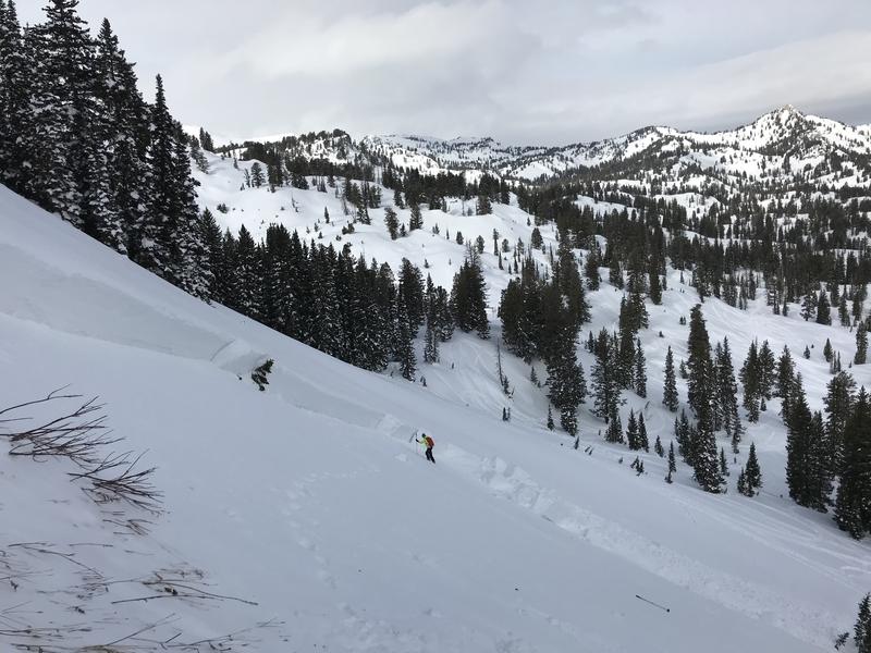
The danger is LOW and the snow is stable on most slopes in the backcountry. Exceptions and areas with MODERATE danger exist on isolated upper elevation slopes facing northwest, north, and east, where people might trigger dangerous avalanches failing on a deeply buried persistent weak layer. Wet avalanches are also possible on steep lower elevation slopes, with rain falling this afternoon on already saturated snow.
- Use normal caution. Evaluate snow and terrain carefully.

Low
Moderate
Considerable
High
Extreme
Learn how to read the forecast here
Weather and Snow
It's 28°F at the 8400' Tony Grove Snotel this morning, and there is 76 inches of total snow, containing 122% of normal SWE. Winds are currently blowing from the southwest around 20 mph, and it's 23°F at the 9700' CSI Logan Peak weather station.
You can still find decent riding in sheltered shady terrain, but warmth, rain, and wind have taken toll, and the snow conditions are quite variable across the Logan Zone.
Expect mostly cloudy conditions in the mountains today, with 8500' high temperatures around 34°F, and 8 to 11 mph southwest winds. Snow and rain showers are likely in the afternoon, with temperatures falling to around 21°F by evening. Expect snow tonight, with 3 to 5 inches possible, steady temperatures around 23°F, and 10 to 15 mph west-northwest winds, increasing to 16 to 21 mph after midnight. Snow will continue in the mountains Monday morning, with another inch or so possible. It will be cloudy, with a high temperature near 28°F, and 11 to 17 mph west-northwest wind. The next storm system is expected to impact the zone late Tuesday through Wednesday morning, with high pressure setting up over the area for later in the week.
Recent Avalanches
We are very sad to report an avalanche fatality that happened Saturday, 1-18-2020 above Farmington Canyon. A 18 year old, male snowmobiler was caught, fully buried and killed. The final report is available HERE. Our deepest condolences go out to the friends, family, rescuers, and everyone affected by this tragic accident.
Sunday, 1-19-2020, a solo skier triggered and was caught and carried by a huge avalanche in Miller Bowl near Tony Grove Lake. Luckily, the skier was spit out the flank at the bottom, just as the very deep pile of debris came to a stop. The avalanche on a repeater path at about 8700' was 4 to 5 feet deep and about 350 feet wide. It failed on a deeply buried sugary persistent weak layer near the ground with a loud thunderous roar, and took the skier under the snow for a harrowing spin-cycle ride. The very lucky skier lost both skis and ski poles, but is happy and grateful to have walked out alive.
Avalanche Problem #1
Persistent Weak Layer
Type

Location

Likelihood

Size

Description
Human triggered avalanches failing on a buried persistent weak layer are possible on isolated upper elevation slopes. Apparently, some avalanches can step down into buried persistent weak layers, involve large volumes of snow, and be quite dangerous and destructive. Recent activity in the zone shows that the weight from last week's snow and drifting was enough to reactivate the deeply buried October persistent weak layer on some slopes. You can still find this weak sugary basal layer lurking on upper elevation slopes facing northwest, north, and east.

Paige is approaching the crown on the western flank of last Sunday's Miller Bowl Avalanche, which failed on a deeply buried persistent weak layer.
Avalanche Problem #2
Wet Snow
Type

Location

Likelihood

Size

Description
Loose wet avalanches are possible on steep lower elevation slopes with melt-softened, saturated snow. Rain falling on the snow later this afternoon will cause increasing danger.
- Avoid travel on or under steep slopes with saturated snow.
- Roller balls, pin-wheels, and loose sluffs indicate potentially unstable wet snow.
Additional Information
We noticed a few large fresh roof avalanches off metal barn roofs in the Bear Lake Area on Friday. Many are still holding lots of heavy snow, and gradual melting is causing them to drip and creep. Warmth and rain at lower elevations today could cause some of them to slide off. Keep and eye on the kids, animals, and vehicles because more significant roof avalanche activity is likely in coming days.

Here is a short video about Saturday's tragic fatal accident in Farmington Canyon.
General Announcements
Are you looking to improve your avalanche skills? We are offering a Backcountry 101: Introduction to Avalanches class at Powder Mountain February 14-15. Info and sign up HERE
The anual CROWBAR backcountry ski race will be on Saturday, February 8. The unique and classic backcountry race will be held at the Swan Flat/Garden City Trailhead in upper Logan Canyon. There are four divisions (Junior, Recreation, Heavy Metal & Race) with different climbs, descents, and technical booters. Participants must carry avalanche rescue gear (beacon, shovel, probe) and can use alpine touring gear, telemark skis, or splitboards. Register on UltraSignup, or sign up to volunteer at this year's race!
Thanks to the generous support of our Utah ski resorts and Ski Utah, we have discount lift tickets available. All proceeds from these go towards paying for avalanche forecasting and education! Get your tickets HERE.
EMAIL ADVISORY. If you would like to get the daily advisory by email you subscribe HERE.
Remember your information can save lives. If you see anything we should know about, please help us out by submitting snow and avalanche observations....HERE. You can also call us at 801-524-5304, email by clicking HERE, or include #utavy in your tweet or Instagram.
This forecast is from the USDA Forest Service, which is solely responsible for its content. The forecast describes general avalanche conditions and local variations always occur.
I will update this forecast before about 7:30 tomorrow morning.