Forecast for the Logan Area Mountains

Toby Weed
Issued by Toby Weed for
Saturday, January 26, 2019
MODERATE: Heightened avalanche conditions exist, and you could trigger shallow wind slab avalanches in drifted upper and mid elevation terrain. Dangerous and scary 3-feet-deep hard slab avalanches failing on a buried persistent weak layer are gradually becoming less likely yet remain possible on some very steep upper and mid elevation slopes. Clouds and a breeze will help today, but solar warming could cause heightened risk of loose wet avalanches on steep sunny slopes this weekend. You can find safer conditions, better stability, and nice fast shallow powder on lower angled slopes, at lower elevations, and in sheltered terrain.
Evaluate snow and terrain carefully.
Low
Moderate
Considerable
High
Extreme
Learn how to read the forecast here
Special Announcements
Yesterday a snowmobiler was buried by an avalanche in the La Sal Mountains of southeastern Utah. Members of his party were unable to locate him. Search and rescue personnel will continue the search this morning. We will provide more information as it becomes available.
Weather and Snow
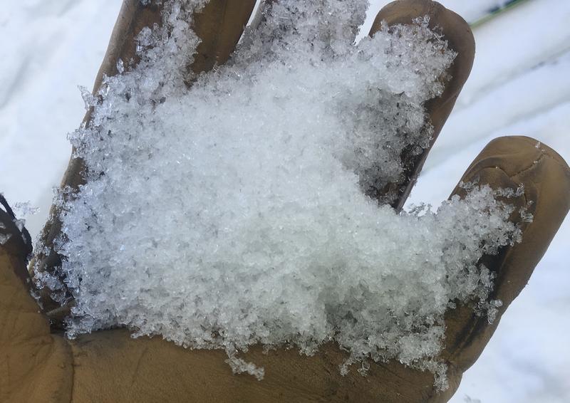
It's been about a week since we've seen natural avalanche activity in the Logan Zone and no new avalanches were reported this week. Drifting from west and northwest winds created heightened conditions on some upper and mid elevation slopes, and you might trigger small avalanches consisting of wind drifted snow. Dangerous hard slab avalanches failing on a persistent weak layer are gradually becoming less likely for people to trigger. Stability has also improved on lower elevation slopes, where cold temperatures solidified rain-saturated snow. We found nice shallow powder and stable conditions in sheltered areas, on lower angled slopes, and at lower elevations. Warming and periods of sun this weekend may create heightened wet avalanche conditions on steep sunny slopes.

The Tony Grove Snotel at 8400' reports 20º F this morning and there's 60" of total snow containing 92% of average SWE for the date. It's 14º F, at the 9700' CSI Logan Peak weather station, and northwest winds are currently averaging around 33 mph, with gusts in the mid 40s.
A series of weak storm systems will move through the Logan Zone, bringing periods of minor mountain snow accumulations and temperatures near seasonal normals. Today it'll be mostly cloudy in the mountains, high temperatures at 8500' around 29º F, and 15 to 20 mph north-northwest winds. Tonight will be partly cloudy, with low temperatures around 18º F, and 10 to 15 mph north-northwest wind. Tomorrow will be partly sunny, with temperature around 32º F, and 10 to 15 mph west-northwest wind, increasing in the afternoon.
Recent Avalanches
-A backcountry skier was buried by an avalanche and killed near Fairview late Thursday, 1/18/19. Search and rescue teams from Emery and Sanpete County recovered his body Friday near Electric Lake on the Manti Skyline. Preliminary report is HERE.
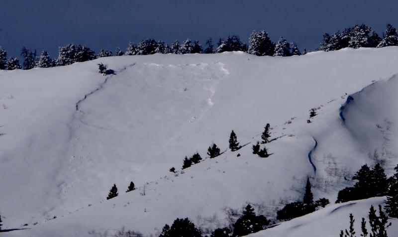
-Natural avalanches were widespread across the Logan Zone late last week, but they're covered up by fresh snow now so not so obvious. Natural avalanches of note include somewhat blown-in evidence of large hard slab avalanches on many paths in the Wellsville Range, and in the Bear River Range, including big ones in Wood Camp, Tab Hollow, Logan Dry Canyon, and Castle Rock near Naomi Peak.
I could see evidence of a large hard slab avalanche in off the Beirdneau Ridge in Tab Hollow.

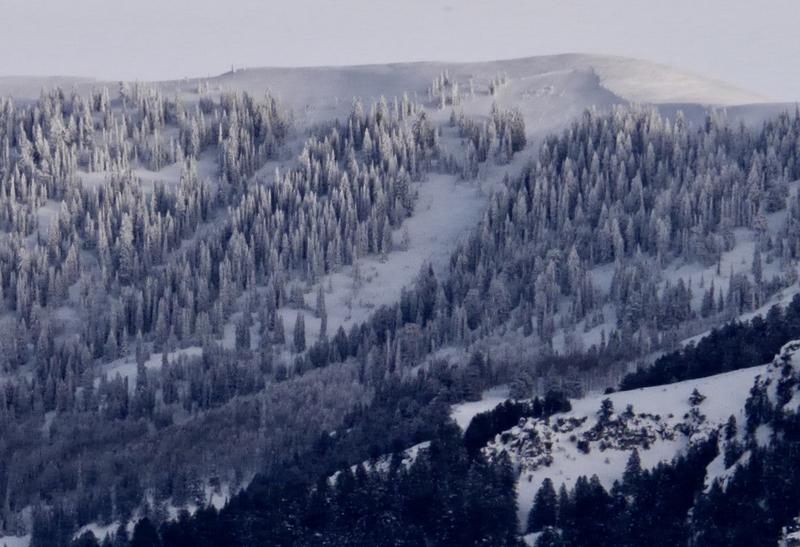
A large natural avalanche on Oscar Mayer in Logan Dry Canyon as viewed from North Logan on 1/22/19
Ad
Avalanche Problem #1
Wind Drifted Snow
Type
Location
Likelihood
Size
Description
Wind drifted snow is causing heightened avalanche conditions in exposed upper and mid elevation terrain. Triggered wind slab avalanches, 1 to 2-feet-deep are possible in some areas.
Wind slab avalanches involve drifts ranging from very soft, (freshly formed from light powder), to very hard (older, from very strong wind). Soft, fresh wind slabs are often quite sensitive to triggering. You usually can trigger from the top, manageable. Hard wind slabs can be tricky, sometimes allowing people to get out on then before releasing.
  • Wind slabs are smooth and rounded looking drifts on steep slopes, and they sometimes make hollow drum-like sounds when you move around on a harder one.
  • Avoid stiffer drifts in and around terrain features like sub ridges, cliff bands, stringers, scoops, and gullies.
Avalanche Problem #2
Persistent Weak Layer
Type
Location
Likelihood
Size
Description
Mid-pack weak layers developed during the New Years cold spell, and shallow snow in many areas is loose, sugary, and faceted. Hard slab avalanches, around 3-feet-deep and failing on buried persistent weak layers, could be remote triggered on steep slopes with poor snow structure, meaning you might trigger one from a distance, or below. The weak faceted snow will cause very steep slopes in the backcountry to be unstable as they only gradually adjust to the recent new snow and drifting. The sugary snow will remain weak, but with little load in the past week, stability on most slopes is increasing. So, there is low probability that you could trigger a dangerous high consequence avalanche. You can find nice snow and much more stable conditions in lower angled, sheltered, and lower elevation terrain this weekend, so you can avoid very steep drifted slopes with shallow snow cover and poor snow structure.
Chains of well developed, loose faceted snow. Weak sugary snow like this is widespread in the Beaver Creek Canyon Area in places where the snow is less than about a meter deep.
Avalanche Problem #3
Wet Snow
Type
Location
Likelihood
Size
Description
Loose avalanches involving wet snow are possible this weekend on very steep sunny slopes with saturated snow. Looks like clouds and a north breeze will probably keep the surface snow chilled today, But, when the sun come out, as will be the case tomorrow, you'll need move off and out from under steep slopes with saturated surface snow.
Additional Information
I will update this forecast Monday morning.
Now is a great time to practice companion rescue techniques with your backcountry partners. You should check out and use the new Avalanche Beacon Training Park we set up at the Franklin Basin trailhead. Special thanks to Northstars Ultimate Outdoors and USU Outdoor Program for helping us to make this possible.
General Announcements
The Beaver Mountain Backside is the backcountry, and it is avalanche terrain. If you cross the ski area boundary, you and your partners should carry and practice with avalanche rescue equipment.
Check out the improved weather links, road conditions, and weather links for each forecast region on the new UAC IOS App. Do you use the NOAA point forecast? If so, now you can bookmark your favorite weather locations in "My Weather" in the App. HERE
Are you new to the backcountry or looking to refresh your skills? The UAC has released a free 5-part avalanche skills eLearning series. HERE
If you would like to get the daily advisory by email you subscribe HERE.
Support the UAC through your daily shopping. When you shop at Smith's, or online at REI, Backcountry.com, Patagonia, NRS, Amazon, eBay by clicking on these links, they donate a portion of your purchase to the UAC. If you sell on eBay, you can have your See our Affiliate Page for more details on how you can support the UAC when you shop
Remember your information can save lives. If you see anything we should know about, please help us out by submitting snow and avalanche observations. HERE You can call us at 801-524-5304, email by clicking HERE, or include #utavy in your Instagram.
This forecast is from the U.S.D.A. Forest Service, which is solely responsible for its content. The forecast describes general avalanche conditions and local variations always occur.