Forecast for the Logan Area Mountains

Toby Weed
Issued by Toby Weed for
Tuesday, January 16, 2024
People are likely to trigger dangerous avalanches, and accidents are likely in the backcountry today.
The avalanche danger is HIGH on drifted slopes at upper and mid-elevations. Dangerous conditions exist, and there is CONSIDERABLE danger in many areas at lower elevations.

People should avoid being in avalanche terrain. Stay off of and out from under drifted slopes steeper than 30°.
Low
Moderate
Considerable
High
Extreme
Learn how to read the forecast here
Special Avalanche Bulletin
Dangerous avalanche conditions exist on many slopes of all elevations. Avalanche accidents often occur under these conditions. Stay off of and out from underneath slopes steeper than 30 degrees.
Special Announcements
Sign up for forecast region-specific text message alerts. You will receive messages about changing avalanche conditions, watches, and warnings...HERE
Weather and Snow
If people venture into avalanche terrain today, they are likely to trigger long-running, destructive, and life-threatening avalanches. Over the weekend, strong, gusty, and sustained winds found plenty of fresh powder to drift into avalanche-starting zones at all elevations. Stiffer slabs now overload a widespread layer of very weak, sugary, or faceted snow from the December dry spell. Dangerous avalanche conditions exist on drifted slopes steeper than 30°.

Winds from the west-northwest picked up again this morning and at 6:00 AM are blowing 36 mph with a 47 mph gust at the 9700' CSI Logan Peak weather station. At 9500' on Paris Peak the wind is blowing 26 mph from the west, and it's a chilly 0° F with a wind chill value of -24° F.
The Tony Grove Snotel at 8400' reports 14° F, with 79 inches of total snow. Somewhere around 4 feet of new snow accumulated at the site in the last week, with 7.4" SWE (Snow Water Equivalent). It's 2° F and there's 56" of total snow at the new Card Canyon weather station.

It will be mostly sunny and cold in the mountains today, with high temperatures around 15° F and moderate winds blowing from the west. The National Weather Service has issued another Winter Storm Warning for the northern mountains in the Logan Zone beginning late tonight and extending through Thursday morning. 16 to 28 inches of snow accumulation, accompanied by strong winds, is expected in upper-elevation terrain.
South of the state line, a Winter Weather Advisory is in effect, with 10 to 17 inches expected up high in the same time period.
Recent Avalanches
Numerous large natural avalanches were observed with clearing yesterday. A handful were remotely triggered and reported by sledders in the Providence Canyon Area. At least one was on a south-facing slope at around 9000' in elevation. Avalanches ranged from about 1' deep down low to 4' deep up high and 100' to 400' wide. Observers report continued widespread collapsing, including in low-elevation terrain in the Logan Canyon Area.
A remotely triggered avalanche in upper Providence Canyon (1-15-24, Wolford)

Check out local observations and avalanches HERE.
Ad
Avalanche Problem #1
Persistent Weak Layer
Type
Location
Likelihood
Size
Description
Large, long-running, and destructive natural avalanches are still likely! Layers of weak sugary snow or facets and feathery surface hoar developed during the prolonged December dry spell on and near the snow surface, and the snow in shallow areas became loose and sugary all the way to the ground. As more new snow and drifting snow overload slopes plagued by this widespread, persistent weak layer, avalanches remain likely. Today, natural and human-triggered slab avalanches could be large, destructive, and possibly life-threatening.
  • Avalanches could be triggered remotely, from a distance, or worse, from below!
  • Collapsing or whumpfs and shooting cracks indicate unstable snow.
Avalanche Problem #2
Wind Drifted Snow
Type
Location
Likelihood
Size
Description
Wind-drifted snow now overloads slopes with poor snow structure, and large avalanches of wind drifted snow failing on the December persistent weak layer are likely. Watch for and avoid stiffer drifted snow on the Lee side of prominent ridges and in and around terrain features like sub-ridges, gully walls, mid-slope rollovers, and cliff bands.
Conditions are a little less dangerous in low-elevation terrain on slopes facing west through southeast where slopes were bare or very crusty before this year's snow started accumulating.
Additional Information
Eric and Amy send in this video from yesterday showing a stability test in the Central Bear River Range.

Check out this short video from our visit to a natural avalanche in the Beaver Mountain Backcountry on Saturday;

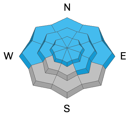
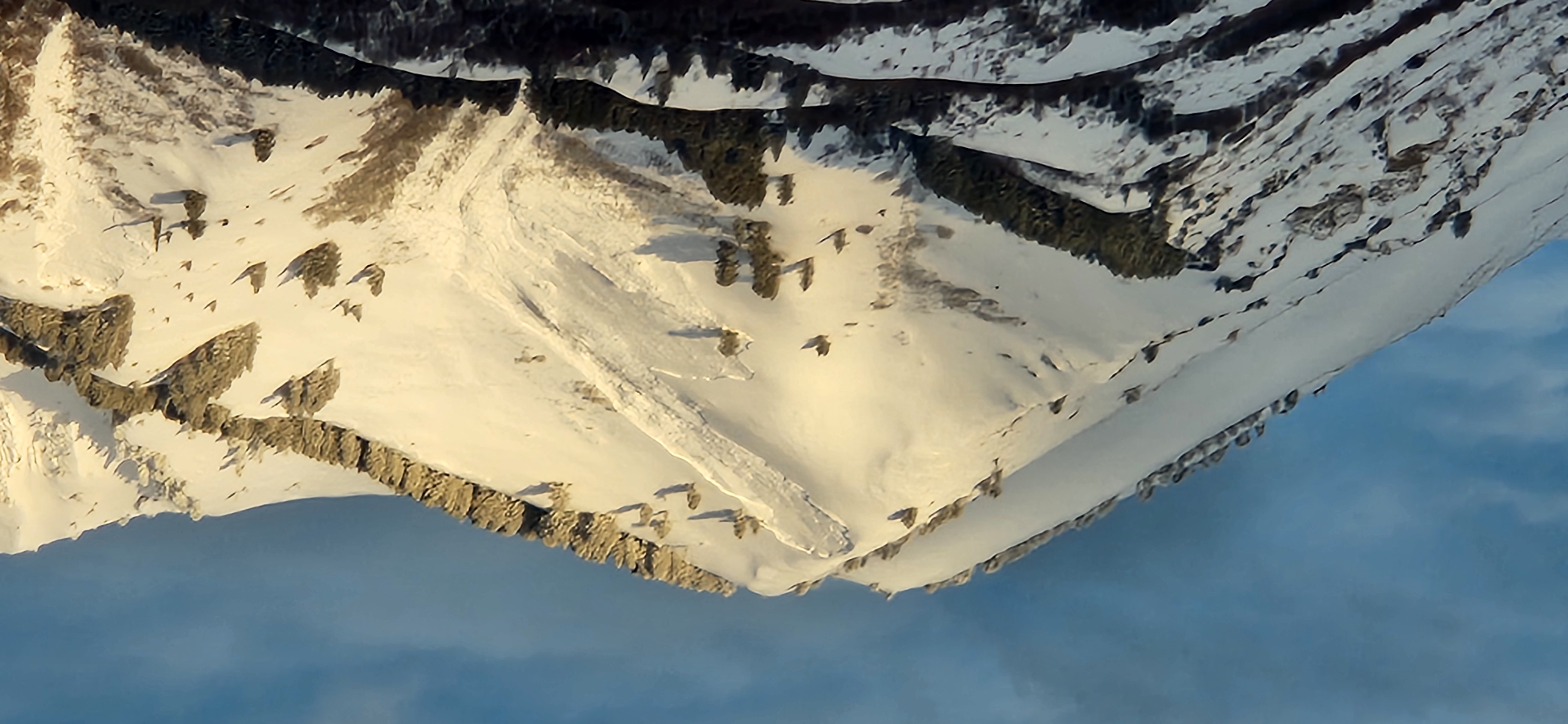
Brett sent this picture of a large natural avalanche in the Wilderness above Wellsville. (1-15-24)

Always follow safe travel protocols on or under slopes steeper than 30°.
  • Be sure everyone in your party has working avalanche rescue equipment, including a transceiver, probe, and shovel. Practice with this equipment regularly, and include and instruct new partners.
  • Cross avalanche paths and runout zones one person at a time, with the rest of the party watching from a safe place.
  • Reevaluate and be willing to change your plans if you encounter any signs of instability, like recent avalanches, audible collapses (whumpfs), or cracking in drifted snow.
General Announcements
-For all questions on forecasts, education, KBYG, events, online purchases, or fundraising: call 801-365-5522.
-To report an avalanche or submit an observation from the backcountry: go HERE.
-We will update this forecast by 7:30 AM tomorrow.
This forecast is from the U.S.D.A. Forest Service, which is solely responsible for its content. This forecast describes general avalanche conditions, and local variations always occur.