Forecast for the Logan Area Mountains

Toby Weed
Issued by Toby Weed for
Monday, January 15, 2024
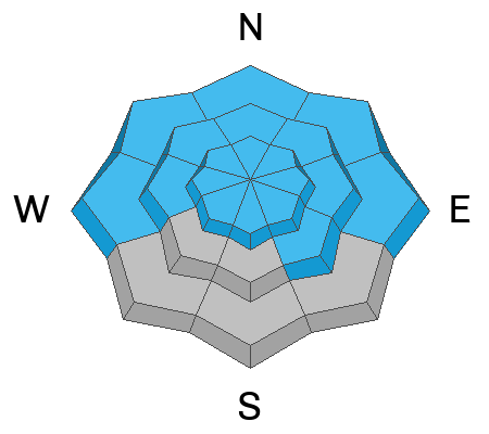
The avalanche danger is HIGH on drifted slopes at all elevations in the backcountry. CONSIDERABLE danger is found on west through southeast-facing slopes at lower elevations.

People should avoid being in avalanche terrain. Avoid evident and historic avalanche paths and runout zones. Stay off of and out from under all drifted slopes steeper than 30°.
Low
Moderate
Considerable
High
Extreme
Learn how to read the forecast here
Avalanche Warning
Strong winds and heavy snowfall have created very dangerous avalanche conditions. Avalanches failing on a widespread persistent weak layer buried under the new snow are certain. Stay off of and out from under slopes steeper than 30°.
Special Announcements
Sign up for forecast region-specific text message alerts. You will receive messages about changing avalanche conditions, watches, and warnings...HERE
Weather and Snow
If people venture into avalanche terrain today, they are likely to trigger long-running, destructive, and life-threatening avalanches. This weekend, strong, gusty, and sustained winds found plenty of fresh powder to drift into avalanche-starting zones at all elevations. Stiffer slabs now overload a widespread layer of very weak, sugary, or faceted snow from the December dry spell. Very dangerous avalanche conditions exist on drifted slopes steeper than 30°.

Yesterday and overnight, winds blowing from the west sustained hourly average speeds around 25 mph, with gusts in the 50s at the 9700' CSI Logan Peak weather station. At 9500' on Paris Peak at 5:00 this morning, the wind is blowing 28 mph from the west, with gusts in the 40s, and it's a chilly 2° F with a wind chill value of -22° F.
The Tony Grove Snotel at 8400' reports 14° F, 83" of total snow, with several more inches of new snow in the last 24 hrs with .8" SWE (snow water equivalent). About 4 feet of new snow accumulated at the site since Tuesday night with 7.7" SWE in the last week. It's 12° F and there's 58" of total snow at the new Card Canyon weather station.

A Winter Storm Warning remains in effect for the mountains in the Logan Zone through today. Expect gradual clearing today, and we may see a little sun this afternoon. Another 1 to 2 inches is expected to accumulate on mountain slopes today. This morning, strong winds will blow from the northwest, gradually decreasing this afternoon. Clearing is expected to continue tonight, and the sun will be out tomorrow leading to bluebird weather and dangerous avalanche accident conditions.
Recent Avalanches
  • An observer reported sizable natural and remotely triggered avalanches at upper elevations on east and southeast-facing slopes in Cottonwood Canyon on Thursday.
  • Despite being unable to see much of the upper-elevation avalanche terrain in the Logan Zone, evidence of numerous natural avalanches was visible at low and mid-elevations in Logan Canyon Saturday. Paige spotted large natural avalanches on White Pine Knob and Chicken Hill in Bunch Grass Canyon and another big one in the Beaver Mountain Backcountry.
  • A skier or snowboarder triggered a small but deep avalanche just above the backside parking spot in Beaver Canyon Saturday afternoon.
  • In Logan Dry Canyon on Sunday, a group of backcountry skiers stopped their run above an obvious rollover and remotely triggered a large avalanche below as they prepared to climb back up the slope.
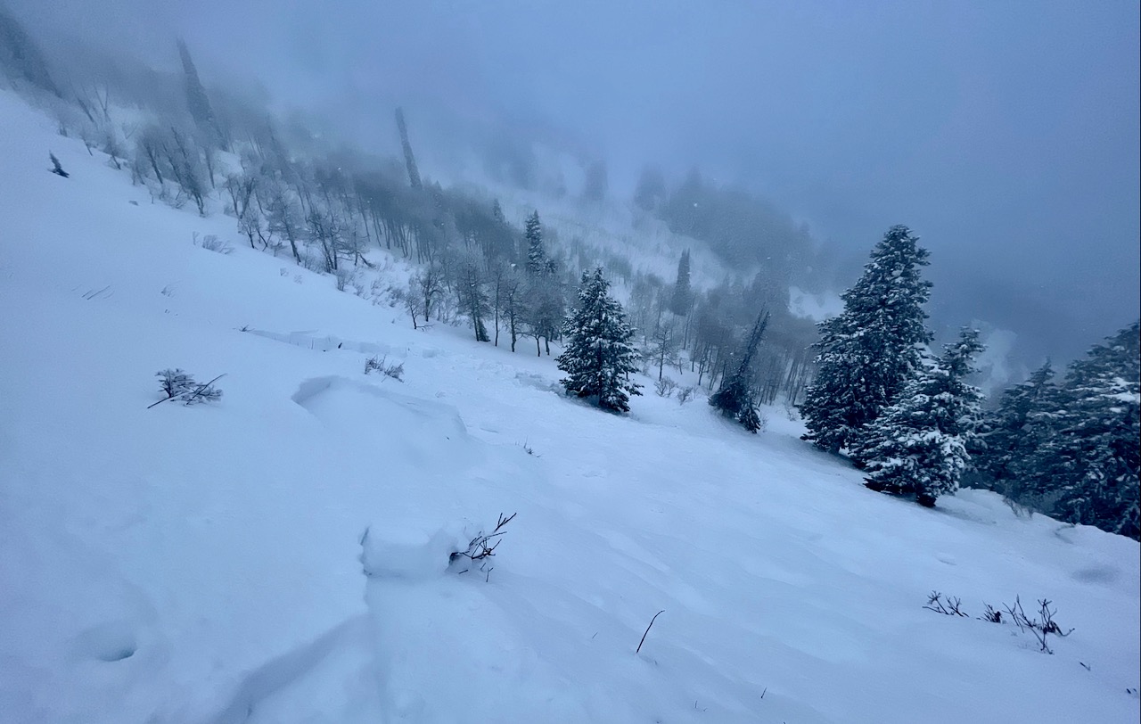
The remotely triggered avalanche in Logan Dry Canyon occurred on a northwest facing slope at around 8000' in elevation.

Check out local observations and avalanches HERE.
Ad
Avalanche Problem #1
Persistent Weak Layer
Type
Location
Likelihood
Size
Description
Large, long-running, and destructive natural avalanches are still likely! Layers of weak sugary snow or facets and feathery surface hoar developed during the prolonged December dry spell on and near the snow surface, and the snow in shallow areas became loose and sugary all the way to the ground. As more new snow and drifting snow overload slopes plagued by this widespread, persistent weak layer, avalanches remain likely. Today, natural and human-triggered slab avalanches could be large, destructive, and possibly life-threatening.
  • Avalanches could be triggered remotely, from a distance, or worse, from below!
  • Collapsing or whumpfs and shooting cracks indicate unstable snow.
Avalanche Problem #2
Wind Drifted Snow
Type
Location
Likelihood
Size
Description
  • Wind-drifted snow now overloads slopes with poor snow structure, and large avalanches of wind drifted snow failing on the December persistent weak layer are likely. Watch for and avoid stiffer drifted snow on the Lee side of prominent ridges and in and around terrain features like sub-ridges, gully walls, mid-slope rollovers, and cliff bands.
People should avoid being on and under drifted slopes at all elevations today.
  • Natural soft slab and loose avalanches of new snow are still likely today on slopes steeper than 30°, even in lower-elevation terrain. Natural avalanches are still likely today on high drifted slopes, and people could easily trigger avalanches at all elevations.
  • Conditions are a little less dangerous in low-elevation terrain on slopes facing west through southeast where slopes were bare or very crusty before snow started accumulating on them.
Additional Information
Check out this short video from our visit to a natural avalanche in the Beaver Mountain Backcountry on Saturday;

Always follow safe travel protocols on or under slopes steeper than 30°.
  • Be sure everyone in your party has working avalanche rescue equipment, including a transceiver, probe, and shovel. Practice with this equipment regularly, and include and instruct new partners.
  • Cross avalanche paths and runout zones one person at a time, with the rest of the party watching from a safe place.
  • Reevaluate and be willing to change your plans if you encounter any signs of instability, like recent avalanches, audible collapses (whumpfs), or cracking in drifted snow.
General Announcements
-For all questions on forecasts, education, KBYG, events, online purchases, or fundraising: call 801-365-5522.
-To report an avalanche or submit an observation from the backcountry: go HERE.
-We will update this forecast by 7:30 AM tomorrow.
This forecast is from the U.S.D.A. Forest Service, which is solely responsible for its content. This forecast describes general avalanche conditions, and local variations always occur.