UDOT PLANNED AVALANCHE CLOSURES!!

Forecast for the Abajos Area Mountains

Dave Garcia
Issued by Dave Garcia for
Wednesday, March 9, 2022
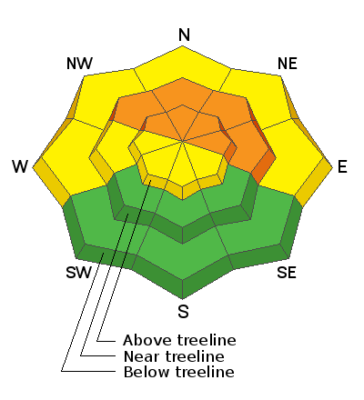
The avalanche danger is CONSIDERABLE on slopes facing NW-N-NE-E at and above treeline. Human triggered avalanches are likely failing on a buried persistent weak layer 2-3 feet below the surface. This weak layer can also be found on slopes facing W, but sun and warm temperature last week have made avalanches on this weak layer less likely. A MODERATE avalanche danger exists on West facing slopes.
You will find a MODERATE danger for triggering an avalanche in wind drifted snow on all aspects above treeline.
South facing terrain at and below treeline offers a LOW danger.
Low
Moderate
Considerable
High
Extreme
Learn how to read the forecast here
Weather and Snow
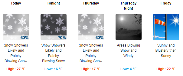
There's another storm on our door step, but this one looks to mainly affect points north. We will see scattered snow showers today with maybe 3 inches by tomorrow. WSW winds will ramp up today and by the afternoon will be blowing 20-25 mph with gusts close to 40 mph. A SW flow will feed into the area on Thursday keeping skies cloudy with lingering snow showers. This system will keep mountain temperatures relatively cold through Friday. Friday and Saturday will see a return to sunny skies.
Snow totals and temps at Buckboard SNOTEL (8924')
Snow totals and temps at Camp Jackson SNOTEL (8858')
Snowpack
It's not been a huge load of new snow but with the fragile nature of the underlying snowpack, it has been enough for a return to dangerous conditions and human triggered avalanches, 1'-2' are likely. The problem is a buried persistent weak layer of loose, sugary, faceted snow that formed during the extended period of high pressure in Jan-Feb. Starting last week, this weak layer has been getting buried and a slab 1'-2' deep exists on top. New and wind drifted snow has added more stress to this weak layer and all that is needed is a trigger such as the weight of a skier or snowmobile. This problem exists primarily on slopes facing W-N-NE-E with possible outlying problems on upper elevevation slopes facing SE.
Recent Avalanches
No recent avalanches have been reported from the Abajo Mountains.
Avalanche Problem #1
Persistent Weak Layer
Type
Location
Likelihood
Size
Description
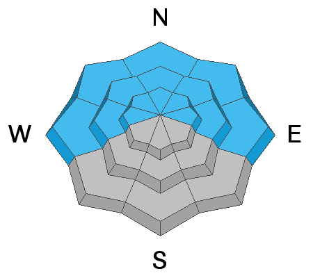
A persistent weak layer of sugary, faceted snow sits beneath a slab 1'-2' thick. New and wind drifted snow now sits on top of this slab adding more stress to the buried weak layer. Human triggered avalanches failing on this weak layer are likely, primarily on steep slopes facing NW-N-NE-E but W facing slopes are also suspect.
This video was shot in the La Sals on Tuesday, March 8th. The Abajos don't have as much snow on top, but they do have the weak, faceted layer underneath. Conditions are similar in both ranges and this video is a good example of what you can expect to see in the Abajos.
Avalanche Problem #2
Wind Drifted Snow
Type
Location
Likelihood
Size
Description
Monday night and Tuesday morning saw moderate winds out of the North. These North winds drifted snow onto Southerly aspects. While skiing yesterday we noticed cross loading in gullies and sub ridges on just about all aspects above treeline. With the next storm on our doorstep the winds will ramp up once again blowing 20-25 out of the WSW today. There is still plenty of light density snow out there available for transport and fresh drifts will be deposited once again above tree line. Avoid rounded, pillowy looking areas. Cracking and hollow sounds are a good indication that you have stepped onto a wind slab.
General Announcements
Who's up for some free avalanche training? Get a refresher, become better prepared for an upcoming avalanche class, or just boost your skills. Go to https://learn.kbyg.org/ and scroll down to Step 2 for a series of interactive online avalanche courses produced by the UAC.
This forecast is from the U.S. Forest Service, which is solely responsible for its content. This forecast describes general avalanche conditions and local variations always occur.