Forecast for the Abajos Area Mountains

Eric Trenbeath
Issued by Eric Trenbeath for
Saturday, March 5, 2022
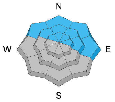
The avalanche danger is MODERATE this morning and human triggered avalanches 1'-2' deep, failing on a buried persistent weak layer of sugary, faceted snow are possible. You are most likely to encounter this problem on steep slopes facing the north half of the compass. With snow and increasing winds in the forecast later today, the danger could rise to CONSIDERABLE this evening. Be alert to changing conditions and signs of increasing danger such as blowing and accumulating new snow.
Low
Moderate
Considerable
High
Extreme
Learn how to read the forecast here
Weather and Snow
This storm was a dud for the Abajos with an inch or two of new snow falling but we'll get another chance later today and tonight as the next system moves in. Look for snow showers to develop later today along with increasing SW winds. 3"-7" are possible by this evening with a few inches more tonight.
Snow totals and temps at Buckboard SNOTEL (8924')
Snow totals and temps at Camp Jackson SNOTEL (8858')
Snowpack
Sun and very warm temps this week have had their way with exposed surfaces but without a solid re-freeze crusts will be punchy this morning. Sheltered, northerly aspects are where you will find the best snow, unfortunately, these are the same areas where you are most likely to find a problem. Though warm conditions this week have helped to strengthen and consolidate the snowpack, a real possibility still exists for triggering an avalanche 1'-2' on a buried persistent weak layer of weak, sugary, facets. This problem is becoming more isolated to slopes facing NW-N-NE but outlying problems may still exist on W and E facing slopes. The weakest snow can be find on shady slopes right around treeline and below, and I expect we will continue to experience signs of instability such as collapsing and whumphing in these areas. The bottom line is that I'm not ready to trust this weak layer, and with snow in the forecast for the weekend, I'm anticipating another round of dangerous conditions.
Avalanche Problem #1
Persistent Weak Layer
Type
Location
Likelihood
Size
Description
We've experienced a week of sensitive and active avalanche conditions as new snow was piled on top of weak, near surface facets that formed during the extended period of high pressure. This persistent weak layer now sits beneath a well consolidated slab 1'-2' thick. Time and warm temps have helped to strengthen the snowpack but signs of instability such as collapsing and whumphing continue to present themselves. It is definitely still possible to trigger an avalanche, primarily on steep slopes facing NW-N-E with the weakest underlying snow existing right around treeline and below. Above treeline, this weak layer is not as widespread but this just makes it more tricky. For now, I'm still not willing to trust any steep, northerly facing terrain. Let's keep it dialed back and see how this next round of snow stacks up.
Avalanche Problem #2
Wind Drifted Snow
Type
Location
Likelihood
Size
Description
Blowing and drifting snow will cause the danger to increase throughout the day. Be alert to the formation of sensitive, fresh drifts on the leeward sides of ridge crests and terrain features. Wind drifting will add more stress to the buried persistent weak layer on northerly facing slopes increasing the odds for a deeper and more dangerous avalanche.
General Announcements
Who's up for some free avalanche training? Get a refresher, become better prepared for an upcoming avalanche class, or just boost your skills. Go to https://learn.kbyg.org/ and scroll down to Step 2 for a series of interactive online avalanche courses produced by the UAC.
This forecast is from the U.S. Forest Service, which is solely responsible for its content. This forecast describes general avalanche conditions and local variations always occur.