Forecast for the Abajos Area Mountains

Eric Trenbeath
Issued by Eric Trenbeath for
Sunday, March 6, 2022
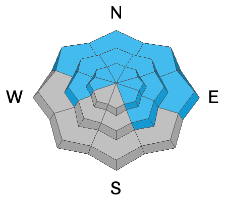
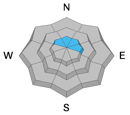
The avalanche danger is CONSIDERABLE on steep, wind drifted slopes facing the north side of the compass, and human triggered avalanches 1'-2' deep, failing on a buried persistent weak layer of sugary, faceted snow are likely. The danger is MODERATE as you wrap around to slopes facing W or SE. Most S and SW facing terrain has generally LOW danger.
Low
Moderate
Considerable
High
Extreme
Learn how to read the forecast here
Weather and Snow
It's not a huge s
Camp Jackson and Buckboard SNOTEL sites are reporting 5"-7" of new snow since Friday night and this could translate to as much as 8"-10" up high. SW winds yesterday evening blew in the 15-35 mph range with gusts in the 30's but they'ce been mostly calm since around midnight. Today, look for mostly cloudy skies with a slight chance for snow, light westerly winds, and high temps in the upper teens. A final shortwave will bring another chance of snow on Monday with dry and sunny conditions on Tuesday. Another system on Wed looks like it will affect areas primarily to the north.
Snow totals and temps at Buckboard SNOTEL (8924')
Snow totals and temps at Camp Jackson SNOTEL (8858')
Snowpack
It's not a huge load of new snow but given the fragility of the underlying snowpack, I think it's enough for a return to dangerous conditions and human triggered avalanches, 1'-2' are likely. The problem is a buried persistent weak layer of loose, sugary, faceted snow that formed during the extended period of high pressure in Jan-Feb. Starting last week, this weak layer has been getting buried and a slab 1'-2' deep exists on top. New and wind drifted snow has added more stress to this weak layer and all that is needed is a trigger. This problem exists primarily on slopes facing NW-N-NE-E but outlying problems may exist on W and SE facing slopes.
Avalanche Problem #1
Persistent Weak Layer
Type
Location
Likelihood
Size
Description
A persistent weak layer of sugary, faceted snow sits beneath a slab 1'-2' thick. New and wind drifted snow now sits on top of this slab adding more stress to the buried weak layer. Human triggered avalanches failing on this weak layer are likely, primarily on steep slopes facing NW-N-NE-E.
This video was shot in the La Sals on Saturday, March 5. The Abajos don't have as much snow on top, but they do have the weak, faceted layer underneath.
Avalanche Problem #2
Wind Drifted Snow
Type
Location
Likelihood
Size
Description
Blowing and drifting snow has caused the danger to increase. Unstable, fresh drifts have formed on the leeward sides of ridge crests and terrain features. Drifts are recognizable by their smooth, rounded appearance and cracking is a sign of instability. Fresh drifts have also added more stress to the buried persistent weak layer on northerly facing slopes increasing the odds for a deeper and more dangerous avalanche.
General Announcements
Who's up for some free avalanche training? Get a refresher, become better prepared for an upcoming avalanche class, or just boost your skills. Go to https://learn.kbyg.org/ and scroll down to Step 2 for a series of interactive online avalanche courses produced by the UAC.
This forecast is from the U.S. Forest Service, which is solely responsible for its content. This forecast describes general avalanche conditions and local variations always occur.