Forecast for the Abajos Area Mountains

Mark Staples
Issued by Mark Staples for
Monday, March 11, 2019
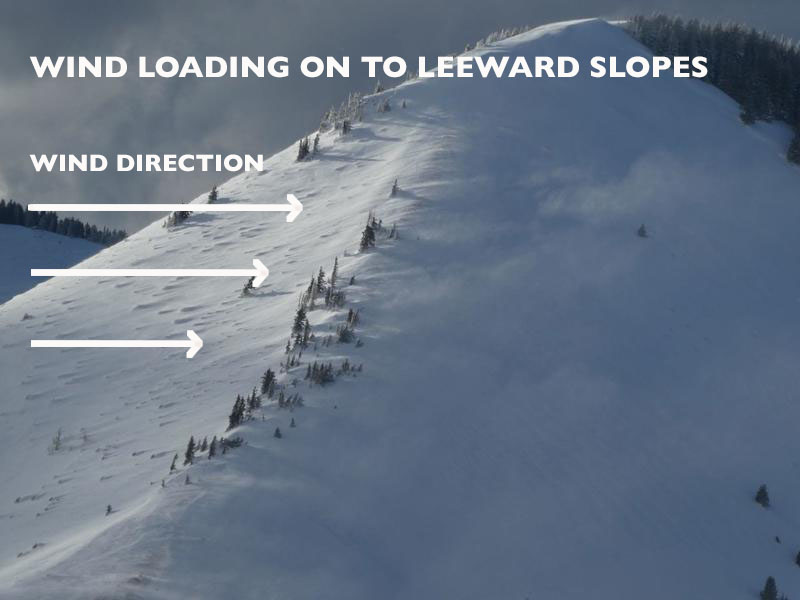
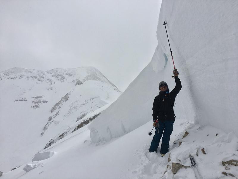
The avalanche danger is CONSIDERABLE today near and above treeline on slopes with wind drifted snow where human triggered avalanches are likely. The avalanche in Horse Creek in the La Sals tells us that these are dangerous avalanche conditions. Below treeline and on slopes without wind drifted snow, the danger is MODERATE.
Low
Moderate
Considerable
High
Extreme
Learn how to read the forecast here
Special Announcements
UAC director Mark Staples will be issuing forecasts for the La Sal and Abajo Mountains while Eric takes a vacation to warmer climates and does a short stint in the SLC office.
Weather and Snow
On Friday the Abajo Mountains picked up 6"-12" of dense, heavy snow accompanied by strong southwesterly winds yesterday. Local observer Kevin Dressel stayed out of the North Creek drainage due to impending avalanche danger from heavy snowfall and blowing and drifting snow. Read his observation here. Read his most recent observation showing wind effects here.
Yesterday high temperatures ranged from the mid 30s to 20 degrees F. One inch of snow accumulated.
This morning temperatures are in the upper 20s F at low elevations and teens F at upper elevations. Winds are averaging 16 mph gusting to 28 mph from the SE.
Today cloudy skies should keep temperatures from rising much more than a few degrees. A few inches of snow should fall this morning. Heavier snowfall should arrive late tonight lasting through Wednesday when there could be a total of a foot of new snow. Winds will remain southerly today at similar speeds. It looks like very strong west winds may arrive on Wednesday.
Photo below shows how winds load slopes with extra snow. Extra snow adds extra weight which means extra stress and avalanches are more likely on these slopes. Avoid these areas with drifted snow.
Photo taken on 03/07 by Kevin Dressel.
Snotel totals at Buckboard Flat (8924')
Snotel totals at Camp Jackson (8858')
Wind, temperature, and humidity on Abajo Peak (11,000')
National Weather Service point forecast.
Recent Avalanches
On Saturday we found a massive natural avalanche on Pre-Laurel Peak that ran into Horse Creek. It was 6-12 feet deep and over 2500 feet wide and broke about 6 inches above the ground. See more pictures HERE. This slope had been loaded by strong SW winds on Thursday & Friday when it likely occurred.
This avalanche is a major red flag and nature's way of warning us that similar avalanches can occur. They will be most likely on slopes with wind-drifted snow. The combined weight of new snow and wind drifted snow has added a lot of stress to slopes. The key to triggering an avalanche like this is tickling the slope in a thin spot sometimes near rocks or other features we can't see. The point is that you or others can typically ride on a slope and put many tracks on it. It won't avalanche until someone finds the wrong spot.
Additional Information
Carry appropriate rescue gear: beacon, probe, shovel, and choose where you ride based on the avalanche forecast for the day!
General Announcements
Your information can save lives. If you see anything we should know about, please help us out by submitting snow and avalanche observations HERE. You can also call me at 801-647-8896, or send me an email: [email protected].
Support the UAC through your daily shopping. When you shop at Smith's, or online at REI, Backcountry.com, Patagonia, NRS, Amazon, eBay by clicking on these links, they donate a portion of your purchase to the UAC. If you sell on eBay, you can have your See our Affiliate Page for more details on how you can support the UAC when you shop
This forecast is from the U.S.D.A. Forest Service, which is solely responsible for its content. This forecast describes general avalanche conditions and local variations always occur.