UDOT PLANNED AVALANCHE CLOSURES!!

Forecast for the Abajos Area Mountains

Eric Trenbeath
Issued by Eric Trenbeath for
Friday, February 25, 2022
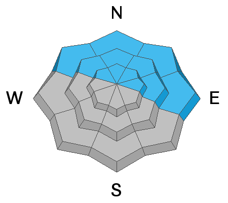
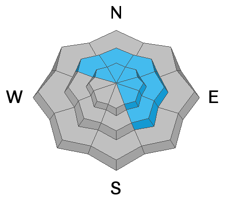
The avalanche danger is CONSIDERABLE and human triggered avalanches are likely on steep slopes that face the north half of the compass. New and wind drifted snow is piling up on a variety of old and weak snow surfaces and a variety of avalanche problems exist. Backcountry travelers need to have excellent route finding and snow stability analysis skills. The danger is generally MODERATE on steep slopes facing the south side of the compass.
Low
Moderate
Considerable
High
Extreme
Learn how to read the forecast here
Weather and Snow
14" -18" of snow has fallen since Tuesday, along with periods of strong southerly winds. Light flurries yesterday produced about an inch. We may see some clouds today with high temps barely breaking 20 degrees. Winds will be light to moderate from the SW. Dry and slowly warming conditions will carry us through next week.
Snow totals and temps at Buckboard Flat (8924')
Snow totals and temps at Camp Jackson (8858')
In my travels yesterday I found excellent powder snow and sensitive, dangerous avalanche conditions. Heading up North Creek I was able to remotely trigger this avalanche as I passed underneath the slope. This is an obvious red flag sign of instability and areas that have deeper snow, will produce deeper and more dangerous avalanches.
Avalanche Problem #1
Persistent Weak Layer
Type
Location
Likelihood
Size
Description
Recent and wind drifted snow has piled up on a variety of old snow surfaces and faceted, weak layer combinations. The weakest snow can be found on sheltered, northerly aspects, and this is where you are most likely to trigger an avalanche failing on a buried persistent weak layer. The only safe strategy at this time is avoidance of steep slopes facing NW-N-NE-E.
Avalanche Problem #2
Wind Drifted Snow
Type
Location
Likelihood
Size
Description
Deep, unstable wind drifts have formed on the leeward sides of ridge crests and terrain features, near treeline and above, primarily on slopes facing NW-N-E-SE. Triggered wind slabs can produce avalanches up to 2' deep or possibly greater and all steep, wind drifted slopes should be avoided.
Avalanche Problem #3
New Snow
Type
Location
Likelihood
Size
Description
Human triggered avalanches within the new snow remain possible on steep slopes on all aspects. These will come in the form of either loose snow or sensitive soft slabs. South facing slopes have less snow on them because of prevailing winds over the last several days, but any steep slope with more than about 8" of snow should be considered suspect.
General Announcements
Who's up for some free avalanche training? Get a refresher, become better prepared for an upcoming avalanche class, or just boost your skills. Go to https://learn.kbyg.org/ and scroll down to Step 2 for a series of interactive online avalanche courses produced by the UAC.
This forecast is from the U.S. Forest Service, which is solely responsible for its content. This forecast describes general avalanche conditions and local variations always occur.